

Tracking how Earth's climate is changing requires data that are consistent, long-term, and freely accessible. ESA’s Climate Change Initiative (ESA CCI) – an R&D programme dedicated to generating robust satellite-derived records of Essential Climate Variables (ECVs) – has recently released an update to its existing Sea State data products. Sea state is one of only 56 ECVs required by the UNFCCC to enable scientists and policy makers to monitor and understand the climate system – and inform action to mitigate or adapt to negative change. Together, the datasets provide detailed measurements of wave height and a wider set of sea state parameters, including wind waves, swell and wave periods.
New and updated Copernicus Sentinel-1 acquisition-mode datasets
The Version 4 release adds new datasets from Extra Wide Swath (EW)and Interferometric Wide Swath (IW) observations, alongside an updated Wave Mode (WV) dataset extending the record to 2024. Analysing Integrated Sea State Parameters (ISSP) derived from Copernicus Sentinel-1 Wave Mode, Extra Wide Swath Mode and Interferometric Wide Swath Mode observations provides a consistent set of parameters describing sea-state conditions across three Copernicus Sentinel-1 acquisition modes. ESA’s Climate Change Initiative (CCI) has produced global multi-sensor time-series of along-track satellite synthetic aperture radar (SAR) Integrated Sea State Parameters for all three Copernicus Sentinel-1 acquisition modes with a particular focus on use in climate studies.
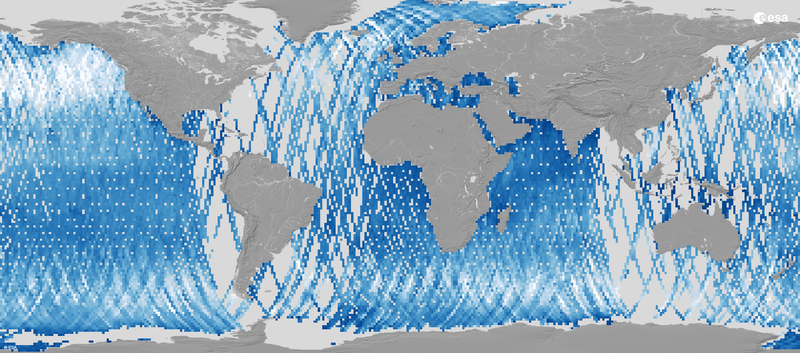
- Wave mode: The Sea State CCI Version 4 release extends the existing Wave Mode dataset to cover 2014 to 2024. Wave mode can help to determine the direction, wavelength and heights of waves on the open oceans. This product provides along-track primary significant wave height measurements and secondary sea state parameters, using machine learning techniques trained on CMEMS (Copernicus Marine Service) model data and reference in situ measurements at 20km resolution every 100km. Access the dataset
- Extra Wide Swath mode: New in the Sea State CCI Version 4 release, the dataset adds sea-state measurements derived from Copernicus Sentinel-1 Extra Wide Swath observations to the climate record. Extra Wide Swath mode provides broad-area radar coverage for maritime, sea-ice and polar monitoring, where frequent observations of large and remote regions are needed. Covering 2014 to 2024, the dataset provides along-track significant wave height measurements and secondary Integrated Sea State Parameters, derived using machine-learning techniques trained on CMEMS model data, at 17.5 km resolution for each image. Copernicus Sentinel-1 acquires EW observations across swaths more than 400 km wide, while quality flags and uncertainty estimates support interpretation of the measurements. Access the dataset
- Interferometric Wide Swath mode: Newly added to the Sea State CCI Version 4 release, the dataset is based on Copernicus Sentinel-1 Interferometric Wide Swath observations. Interferometric Wide swath mode is Copernicus Sentinel-1’s main radar acquisition mode over land, combining broad coverage with relatively fine spatial detail. From 2014 to 2024, Copernicus Sentinel-1 acquired IW images covering approximately 200 km in azimuth and 250 km in the range direction. The resulting dataset delivers significant wave height and secondary Integrated Sea State Parameters derived using machine-learning techniques trained on CMEMS model data, at 5 km resolution, with quality flags and uncertainty estimates to support their use. Access the dataset
Significant wave-height observation record extended
The Sea State CCI Version 4 release provides a temporal extension to two dedicated Significant Wave Height (SWH) records: a multi-mission satellite altimetry record covering 1991–2023 and a Copernicus Sentinel-1 Wave Mode record covering 2015–2025. Significant Wave Height is the standard measure used to describe sea state. It is defined as four times the local standard deviation of the sea surface elevation. It helps scientists monitor storms, understand how wave energy travels across oceans, improve forecasts, and assess how changing climate patterns may influence coastal hazards and marine operations. Together, the two updated datasets provide detailed global, along-track observations of wave height.
- Updates to the altimetry Level-2P (L2P) product extend the record to 1991–2023, compared with the previous version (2002–2021). The new version combines observations from 12 satellite missions, including ESA’s ERS-1, ERS-2, Envisat and CryoSat-2; the Copernicus Sentinel-3A and Copernicus Sentinel-3B missions; and the TOPEX/Poseidon and Jason missions, developed through partnerships involving the French space agency CNES and NASA. The new dataset provides measurements at approximately 6 km resolution, alongside quality flags, corrections and additional parameters. The different missions have been carefully intercalibrated using TOPEX and the Jason series as a reference, which is itself calibrated with in situ data. Access the dataset
- The Sea State CCI Version 4 release extends the separate Copernicus Sentinel-1 Wave Mode (WV) significant wave-height product from the previous Version 3 record to cover 2015 to 2024. Complementing the separate Wave Mode Integrated Sea State Parameters dataset, this product focuses on a consistent record of significant wave height derived with the Quach et al. statistical model, supporting analyses of changes in wave height over time. The Wave Mode significant wave height product delivers measurements at 20 km resolution every 100 km, with quality flags, corrections and additional parameters. Access the dataset
Multi-mission satellite altimetry extends daily and monthly wave-height record
The Sea State CCI Version 4 release extends the Level-3 (L3) and Level-4 (L4) multi-mission altimetry datasets both backwards with earlier ERS-1, ERS-2 and TOPEX/Poseidon missions and forwards with three further years of observations, with a particular focus on its use in climate studies, such as examining long-term changes in wave conditions and extreme waves across ocean regions. Complementing the Copernicus Sentinel-1 Wave Mode datasets described above, the altimetry datasets merge measurements from successive satellite missions to provide a longer record of wave height along satellite ground tracks.
- Version 4 extends the Level-3 (L3) record from 2002–2021 to 1991–2023, adding earlier satellite missions and three further years of observations. The Level-3 (L3) product, generated from upstream Sea State CCI Level-2P (L2P) products. It merges global daily along-track records, retaining only valid and good-quality measurements from all available satellite altimeters over a single day at approximately 6 km spatial resolution. The longer record supports analyses of significant wave-height variability and change over more than three decades. Access the dataset
- Version 4 extends the Level-4 (L4) record from 2002–2021 to 1992–2023 by adding earlier satellite missions and three further years of observations. The Level-4 (L4) product aggregates the same multi-mission observations into monthly significant wave-height data gridded over a global regular cylindrical projection at 1°x1° resolution. Designed for statistics and visualisation, the gridded record supports analyses of regional wave patterns and long-term changes in significant wave height. Access the dataset
Why sea state matters
Sea state describes wind-generated ocean waves, including their height, period and direction. These waves contribute to sediment transport and extreme sea levels at the coast, the evolution of sea ice, and air-sea fluxes. Reliable wave observations are needed to assess conditions affecting ships, offshore platforms and coastal defences. The wave climate is used to design and operate structures at sea and on the coast. The Sea State project contributes to ESA’s Climate Change Initiative (CCI), which develops long-term satellite data records for Essential Climate Variables defined by the Global Climate Observing System, helping researchers and policymakers monitor Earth’s climate system and inform action towards the goals of the Paris Agreement.