
Frequently Asked Questions
This page provides a series of FAQs. For more details on the product, please see the Product User Guide (PUG). In addition, both Dorigo et al. (2017) and Gruber et al. (2019) provide a good overview of the product and algorithm.
Acessing and Using the Data
How can I download the data?
Please download the data from our FTP, after registration. For more details, see the data access and download page. This page also provides details on how to view and use the product.
My login credentials do not work.
Please carefully read the guidelines on accessing data from our FTP. The login credentials will not work on our website! A description on how to use FTP software is provided together with the access credentials you received via e-mail after registration. Make sure the server address (host), username, password, protocol and port is correct. If you still have problems contact us by e-mail at "CCI_SM_CONTACT (at) eodc.eu".
I have registered before, but now a new version of ESA CCI SM is available. How can I access the new version?
You have to re-register for each release. Please fill out a new registration form.
The FTP folder is empty.
This means we have released a new version of ESA CCI SM since you received your FTP credentials. Please re-register to get access to the new version, or browse the CEDA archive to access older versions of ESA CCI SM.
What format is the data in?
The data is provided as global, daily netCDF files (i.e. one file for each day of the product). On the FTP you will find zipped as well as unzipped versions.
How do I cite the data?
A list of references which should be cited when using the data are provided on the publications page as well as in the global attributes of the netCDF files.
Is the product available in near-real time?
The product is not available in near-real time, however, a near-real time soil moisture product can be downloaded from the Copernicus Climate Data Store. This product is based on the ESA CCI SM algorithm.
How do I convert volumetric soil moisture to soil wetness content?
SM (%) = SM_vol (m3m-3) / porosity_vol (m3m-3).
The ancillary porosity map provided with the Soil Moisture data set is expressed as volumetric percent (m3m-3 * 100%). For the computation, we used the equations of Saxton and Rawls (2006) which take clay, sand, silt, and organic matter as input. Both the soil fractions and equations may cause errors, especially at the global scale. In practice, you can use any porosity data set as input.
How can I access previous versions of ESA CCI SM?
We only provide access to the latest version of ESA CCI SM on our website. However, previous versions are archived and can be downloaded via the CEDA platform.
Product Characteristics
What products are available?
There are three products available:
- ACTIVE - based on active scatterometer data
- PASSIVE - based on passive radiometer data
- COMBINED - based on a combination of the active scatterometer data and the passive radiometer data and including a temporal break correction.
What is the spatial and temporal coverage of the product?
The current product, v08.1 covers the period November 1978 to the end of 2022 for the PASSIVE and COMBINED product and from January 1991 to the end of 2022 for the ACTIVE product.
What is the observation density of the product like?
The fraction of number of observations is shown in the following figure for the COMBINED product of v08.1. Note that at the start of the product, there is significantly less temporal coverage than in the later periods. This is due to to the product (COMBINED and PASSIVE) being based only on the SMMR radiometer.
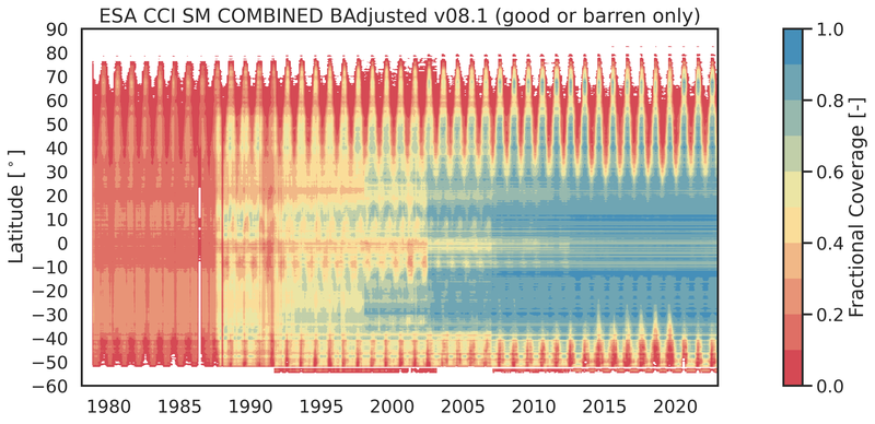
Why are there less observations in some areas?
For areas with dense vegetation (tropical, boreal forests), strong topography (mountains), ice cover (Greenland, Antarctica, Himalayas), a large fractional coverage of water, or extreme desert areas we are not able to make meaningful soil moisture retrievals. Hence, these data are masked in the final product.
Which sensors are used in the product?
The following sensors are used in the production of ESA CCI SM v08.1:
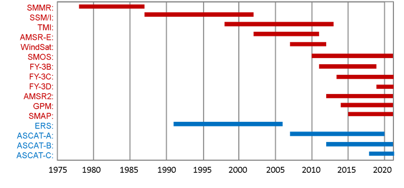
In particular, the following datasets are used:
- ASCAT-A and -B data are generated through the HSAF soil moisture project which can be accessed on the EUMETSAT HSAF soil moisture website. At v08.1, version H119/120 of the data record is ingested.
- ERS data is processed by the Microwave Remote Sensing Group at TU Wien.
- All passive datasets are processed using the LPRMv7 algorithm, designed and implemented by Planet.
How has the data been verified and validated?
More information on the verification and validation of the product can be found on the Validation page.
Other FAQs
Is the product the "absolute" truth?
The COMBINED data set is rescaled to GLDAS v2.1 prior to merging. We perform this processing step to obtain a final product in absolute volumetric units [m3/m3]. Even though the original dynamics of the remote sensing observations are preserved, this step imposes the absolute values and dynamic range (min-max) of the GLDAS-Noah product on the combined product. As a consequence, the combined product CANNOT be considered an independent data set representing absolute true soil moisture.
Why do the provided soil moisture images appear in data stripes?
Microwave images from the earth's surface are taken while the satellite is orbiting the earth in fixed paths. This is particularly apparent at the start of the data period, but as we reach the present, the spatial data density gets higher and these stripes are no longer apparent.
How should I interpret the soil moisture noise layer?
The noise layer gives you information about the random uncertainty of the retrieval and, hence, about the quality of it.
Which of the products (ACTIVE, PASSIVE or COMBINED) is most suitable for model verification?
In theory, the combined product combines the best of the active and passive products, so we would take the merged/combined product.
What is the maximum depth of the observed surface soil moisture?
The ESA CCI SM data set is representative of the first few centimeters of soil (~0-5cm). An exact number cannot be determined as multiple sensors are combined in the data products. The depth depends on the sensors that are actually used at each point in time and their characteristics (active/passive sensor, measurement frequency, etc).