
25 de mayo de 2023
Satellite sea ice record made even sharper
New 30 year sea ice product provides a higher resolution record than that available via Eumetsat's OSI SAF
The decline of Earth's ice serves as a clear indicator of climate change.
A new high-resolution sea-ice concentration dataset has been released by ESA’s Climate Change Initiative based on new research by its Sea ice project team.
The new product offers a sharpened picture of sea ice distribution worldwide and provides an advance, refined version of the sea ice data from Eumetsat OSI SAF.
Spanning 30 years (1991-2020), the new product is 10 years shorter than the full satellite record but offers a more detailed view.

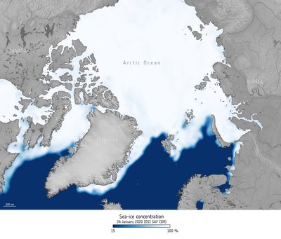
An increased level of detail can be seen when comparing images of the CCI's higher resolution image (above right) with the existing Eumetsat OSISAF dataset (below, right), especially at the edge.
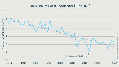
Sea ice concentration and thickness has been in decline since the satellite era began in 1979 – a response to increasing global temperature.
Sea ice is a key component of the climate system, playing an important role in regulating global weather patterns, and oceanic currents, while its high albedo keeps the region cool. Satellite observations have been critical in providing the evidence to enable science and policy circles to systematically observe the climate to support the UNFCCC.
The CCI Sea ice project team processed high-frequency (near-90 GHz imagery; 12.5 km), higher-resolution imagery from the Special Sensor Microwave Imager (SSM/I) and the Special Sensor Microwave Imager Sounder (SSMIS) to produce a pan-sharpened product that gives a clearer picture of sea ice concentration globally.
The near-90GHz imagery is only available from 1991, but despite its shorter duration, this dataset represents an advanced, refined version of the data from Eumetsat OSI SAF, providing additional details that enhance model predictions and improve our understanding of Arctic dynamics.
The data are derived from microwave imagery and Numerical Weather Prediction data using a dedicated algorithm developed by the CCI Sea Ice team. The accuracy of the data was verified using information from the Copernicus Sentinel-1 radar mission, which offers all-weather sea-ice mapping capabilities.
"We hope that this higher resolution dataset will prove beneficial to users and enable us to gain fresh insights into the regional and local scales that connect sea ice with other components of the Earth system." These extensive datasets, augmented by data from numerous satellites, enable researchers to study long-term trends and variations in the Arctic and Antarctic, contributing to a more profound understanding of how the polar regions respond to global warming and enhancing predictions of future changes," says Thomas Lavergne, science leader of the CCI’s sea ice project team.
He continues, "We anticipate that this higher resolution dataset will bring advantages to its users, helping them gain new perspectives on the regional and local scales that connect sea ice with other elements of the Earth system." This dataset follows the release, a few months prior, of a "historical" sea ice dataset by the CCI Sea Ice team, revealing the formation of sea ice in the early 1970s.
Dirk Notz, from the University of Hamburg, expressed his enthusiasm, stating, "For the climate research community, ESA's new high-resolution sea-ice product is truly exciting! Modelling groups worldwide are currently working on the next generation of climate models, aiming for grid resolutions of just a few kilometres."
"To evaluate these models and better comprehend the processes driving the ongoing loss of sea ice at these scales, having access to satellite data with similar spatial resolution is absolutely essential. This new product arrives at the perfect time!" These long-term datasets, compiled using data from multiple satellites, empower researchers to examine long-term trends and variations in the Arctic and Antarctic, enhancing our understanding of the polar response to global warming and improving predictions of future changes.
Using a technique called "satellite archaeology," the team reanalyzed observations from the Electrically Scanning Microwave Radiometer (ESMR) aboard the Nimbus-5 satellite, allowing them to derive global sea ice concentration and extent from 1972 to 1977, predating the climate data records from modern satellite radiometers (which started in 1979).
Both the new high-resolution dataset and the early-1970s dataset can be accessed and downloaded from the Climate Change Initiative’s Open Data Portal.
Once sufficiently mature, new sea ice concentration data products developed by the CCI sea ice project are transferred to, and extended by, EUMETSAT's Ocean and Sea Ice Satellite Application Facility.