The “sea state” is the statistical description of wind-generated ocean wave properties, including their heights, periods and directions. Waves associated with the local wind form the wind sea, and waves propagating from remote storms are swells. The “sea state climate” is needed in all ocean and coastal engineering applications. The expected extremes over the lifetime of ships, platforms or coastal defences are of particular interest. Ocean waves contribute to sediment transport and extreme sea levels at the coast, the evolution of sea ice, and air-sea fluxes. Finally, ocean waves cause biases and random errors in the satellite measurement of other variables such as sea level.
The project will particularly focus on reducing the noise of sea state parameters, and combining seamlessly different satellite sensors, including the latest Doppler processing of altimeters. Synthetic Aperture Radars are particularly useful for swell properties and are unique in providing swell directions. Because waves are generated by the wind over the open ocean, the sea state climate varies with large scale climate patterns, such as El Niños, and trends. The project database will thus be analysed to identify these patterns in order to help understand ongoing changes in sea state climate.
Objective
The ultimate objective of SeaState_cci is to develop an 18-year data set (2002- 2020) capitalising on the rich satellite altimeter, SAR imager, in situ and other data holdings available during that period. The focus will be on the development, testing and improvement of dedicated sea state retrieval algorithms with respect to climate users' requirements, as compiled at high level by GCOS.
About the project
We start from observation requirements laid out by GCOS, and the needs of both the climate research community, which are particularly laid out in the COWCLIP publications, and key applications communities that include coastal management and shipping. These requirements will be refined and evolved as part of the project.
Of primary concern will be the accuracy and stability of the data set that we will produce. These include
- Significant wave height from satellite altimeters that include all the ESA missions, and Topex/Jason series.
- Wave spectra from radar imagery: all wave mode from ERS to Sentinel 1 and a sample of larger image mode data.
Sea state has never been the main focus of satellite altimetry. Except for the results of the Globwave project and new Copernicus Marine Environment Monitoring Service activities, wind and wave parameters from altimeters were a by-product of sea level estimates, leading to inconsistencies between sensors and satellite missions. Our project will thus carry out algorithm development to ensure the best possible quality of wave and wind products with a particular focus on consistency.
A particular challenge is posed by the strong evolution of measurement techniques, in particular going from Range-only to Delay-Doppler processing, and we will work towards harmonizing the processing to arrive at seamless products than span the years 2003 to 2020 as part of this project, and making possible longer time series in a future phase 2. The data production system will be fully documented, making future transfer possible.
The project will provide time series of wave parameters (by mission - level 2, and consolidated - level 3) and gridded analyses of wave climate parameters (level 4). Based on these products we will work with the Earth observation and climate science community to identify and better analyse key processes that contribute to uncertainties in other ECVs (primarily sea ice and sea level). We will also work with the seismology community to make better use of microseism data for wave event detection and sea state trends analyses. These efforts should contribute to improved sea state models that are now used by seismologists for solid Earth monitoring and tomography.
The Project results, from the new algorithms, to the data set and their application in key areas will published in world class peer-reviewed scientific journals, in particular in time to contribute to IPCC Assessment Reports.
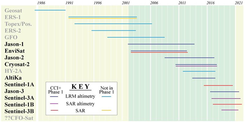
Figure: Schematic showing operating lifetime of relevant satellite sensors, indicating which ones will be processed in Phase 1 of CCI+. (Illustration adapted from Shutler et al., 2016.)