
22 maart 2022
Remote sensing reveals carbon losses in Africa’s rainforests
New study reveals spatial and temporal hotspots
Protecting forests is one of the most effective ways to limit the rise of carbon dioxide in the atmosphere that causes global warming. Climate action has shone a spotlight on rainforests as crucial stores of carbon on Earth, with research highlighting the danger of them becoming sources of carbon emissions when disturbed by human activities, or by wildfires linked to global warming and forest degradation.
A new study has shown the possibility of using Earth observation data to trigger carbon loss alerts for the remote, cloud-covered rainforests of Africa, to empower action on the ground and support these countries in their reporting responsibilities under the Paris Agreement.
Under the Paris Agreement countries are required to present their plans to address the climate crisis. These are known as nationally determined contributions (NDCs) and can include efforts to reduce emissions from deforestation and forest degradation. However, to track progress, the amount of carbon stored in forests must be accurately quantified with reasonable timeliness.
For Africa’s humid rainforests, tracking forest carbon is hindered by the time lag in updating national forest inventories, which in some countries can be several years old and unsuitable to drive mitigation action.
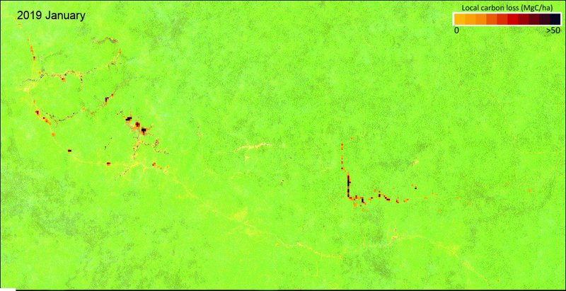
Recent advances in the use of satellite data for tropical forest monitoring however, have given alerts of changes happening in these rainforests on a near-real-time basis. These approaches rely on radar-based information to detect deforestation from the Copernicus Sentinel-1 satellite mission, which is unaffected by cloud cover.
“With these alert systems in place for deforestation events we wanted to go further and attribute carbon values to them for carbon loss alerts,” says lead author Ovidiu Csillik from Wageningen University in the Netherlands.
To do this they combined the deforestation alerts with maps of above ground biomass from the ESA Climate Change Initiative Biomass project for 2019 and 2020.
This enabled the team to determine different drivers of forest disturbance and identify when it was occurring, which is helpful to support agencies in taking action on the ground, enabling them to focus their conservation efforts at times when carbon loss is greatest.
In 2020, in the Central African Republic, the study found that more than three quarters of the total annual carbon loss happened between January and March. In Madagascar, nearly 90% of the annual carbon loss took place August to December. Forest clearing for the expansion of small-scale agriculture is strongly wet and dry season-dependent, with different patterns of deforestation compared to mining for example (see figure).
The team plan to develop the carbon alerts to cover all tropical forests around the world.
“We’ve had interest from some countries for carbon reporting, and are working to make the data products available through an interactive web-mapping application”, says Dr. Csillik.
Reference: Csillik, O., Reiche, J., De Sy, V. et al. Rapid remote monitoring reveals spatial and temporal hotspots of carbon loss in Africa’s rainforests. Commun Earth Environ 3, 48 (2022). https://doi.org/10.1038/s43247-022-00383-z