
A new product released by the ESA CCI Fire project team vastly improves the ability to detect global burned area – land directly affected by wildfires.
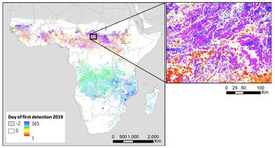
The new product, Fire_cci Sentinel-3 SYN version 1.0 (FireCCIS310), detected a total 4.99 million km2 during the year 2019. This is a 28% increase when compared to the current FireCCI product used to assess global burned area, FireCCI51, over the same period.
Vegetation on land disturbed by wildfire has the potential to release significant greenhouse gas and particulate matter into the atmosphere. The impact of such events on the Earth system is sufficiently important to warrant the inclusion of fire disturbance as one of the only 54 Essential Climate Variables that are required as part of the Global Climate Observing System.
This new product includes surface reflectance information from both the OLCI and SLSTR sensors - known as the Synergy (SYN product) – on board the Copernicus Sentinel-3 satellite mission. This is accompanied by active fire information from the NOAA-20 and Suomi-NPP VIIRS sensor.
The improved burned area detection was achieved as a result of on-going algorithm development and the shorter overpass interval of Sentinel-3 A&B, with the latter providing an almost daily temporal resolution. The active fire data, which comes at a resolution of 375 m, provides the ability to determine affected areas with greater definition, resulting in a clearer picture of burned patches.
The dataset is provided as a pixel-based product at approximately 300 m spatial resolution, and grid product at 0.25-degree resolution. It includes ancillary variables related to the uncertainty of the product, the quality of the observation, and the land cover burned.
FireCCIS310, which is currently processed for 2019 only but is expected to be extended forwards in time, can be accessed and downloaded from the CCI Open Data Portal.
This latest advance builds on the ESA Climate Change Initiative fire project team’s experience of designing algorithms for long term burned area detection at global scale. The longest dataset available currently spans 1982-2018.