Summary
Emerging evidence suggests the Amazon rainforest's ability to absorb carbon is weakening, potentially becoming a source of emissions. Despite this, significant uncertainty remains regarding about the region’s current and projected greenhouse gas (GHG) emissions. To address this gap, the Carbon Amazon Rainforest Activity project is collecting new and detailed observations to improve understanding of GHG emissions trends from natural sources in the Amazon through combined ground, airborne, and satellite observation campaigns across a 100 × 100 km area of the eastern Amazon, Pará State, Brazil.
This study is led by King’s College London and is a collaboration between ESA, research institutions from ESA Member States and Brazil’s National Institute for Space Research (INPE) and Federal University of Western Pará (UFOPA).
Rationale
In its Strategy to Support the Global Stocktake of the UNFCCC Paris Agreement, the Committee on Earth Observing Satellites (CEOS) identifies the Amazon as a potential tipping point of terrestrial carbon emissions in the near future. Despite this, significant uncertainty remains regarding about the region’s current and projected greenhouse gas (GHG) emissions. To address these gaps, CEOS has called for a large-scale field experiment to provide new and detailed observations that improve scientific understanding of emission trends from natural sources in the Amazon Basin. Specifically, to better understand the carbon dynamics in carbon stocks and fluxes (CO2, CH4, N2O) associated with different land cover types and fire.
This project responds directly to this call. It is a collaborative field study involving research institutions from across Europe and Brazil and has been designed to generate new and detailed observations to support assessment of GHG emissions in the Amazon. By integrating ground-based (proximal and in-situ), airborne (remote sensing and in-situ), and satellite observations, the project aims to improve understanding of natural emissions processes and their responses to ongoing environmental change.
Science objectives & experimental set up
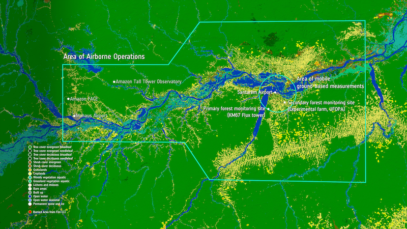
The project comprises a campaign of concurrent airborne sorties and satellite overpasses over an instrumented over the eastern Amazonian study area, around the city of Santarém, Para State.
Ground-based sensors in fixed locations have been deployed in primary and secondary forest, while mobile or ‘roving’ measurements will be used to complement assessment of fire impact around Santarém.
The airborne campaign will study and characterise the region's land area from above using a variety of advanced remote sensing methods, whilst simultaneously sampling the atmosphere to measure the land-atmosphere transfers of greenhouse gases, particulates and various air pollutants, both in and out of primary and degraded forest and also from the regions fires. Airborne activities have been made possible through close cooperation between ESA, participating European research teams, Brazil’s National Institute for Space Research (INPE) and Federal University of Western Pará (UFOPA) – one of the few times such research has been allowed in recent decades.
Science goals
The campaign's science goals aim to improve GHG quantification and Verification, improve fire impact assessment, and support both satellite validation and model development and is focussed across three process-related Science Themes
(I) Landscape Scale (non-Fire) GHG Fluxes
(II) Vegetation Processes and Carbon Storage, and

Study area
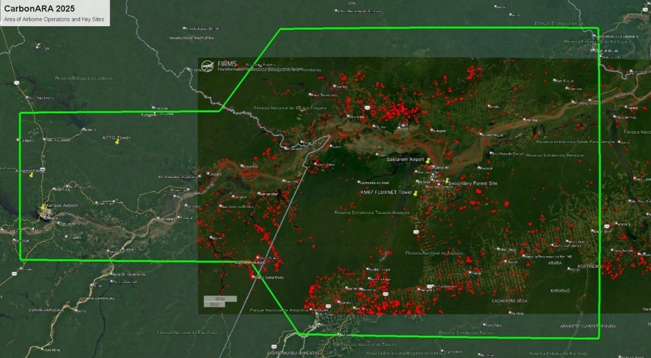
The study area focusses on a 100x100 km area in the western region of Para State, Brazil with locations positioned in and around the city of Santarém (2.441° S, 54.714°E) which includes the full range of land cover types from intact and secondary forest, agriculture and degraded land. The area is primarily of scientific interest as it falls within an area of the Amazon forest which is thought to already exhibit dry-season increases in Gross Ecosystem Productivity and transitioning from a carbon sink to a net emitter or source of carbon. The study area has a number of advantages, making it suitable for an integrated ground-observations campaign:
- Widespread coverage of primary and secondary or degraded forest and other land cover types
- Pre-existing research infrastructure, as part of the Large-Scale Biosphere-Atmosphere Experiment in Amazonia (LBA) led by INPE and experimental farm activities of UFOPA, that can be utilised
- Frequent fire activity is anticipated to coincide with the proposed campaign timing, based on satellite records
- Santarém airport is suitable for hosting the BAS Twin Otter research aircraft, enabling observations from the airborne campaign to be integrated into the study.

Experimental set up - in-situ measurements
The ground campaign incorporates installation of fixed-site instrumentation at two flux tower locations to observe GHG fluxes and vegetation-related variables. One is situated in the Tapajos National Forest (primary forest area) and a second site located at the UFOPA Experimental Farm to observe GHG fluxes in a secondary / degraded forest setting.
Instrument installation was completed prior to the airborne campaign and will take measurements extending from September 2025 into 2026 and potentially beyond to gather a full set of seasonal data.
Mobile, 'roving' measurements wil be taken to study fire events around Santarém area. Deployment locations will be guided by real-time fire satellite information, enabling responsive sampling of fire events to facilitate study these spatially and temporally variable events.
Fixed, ground observation sites
Primary forest site - LBA Tapajos KM67
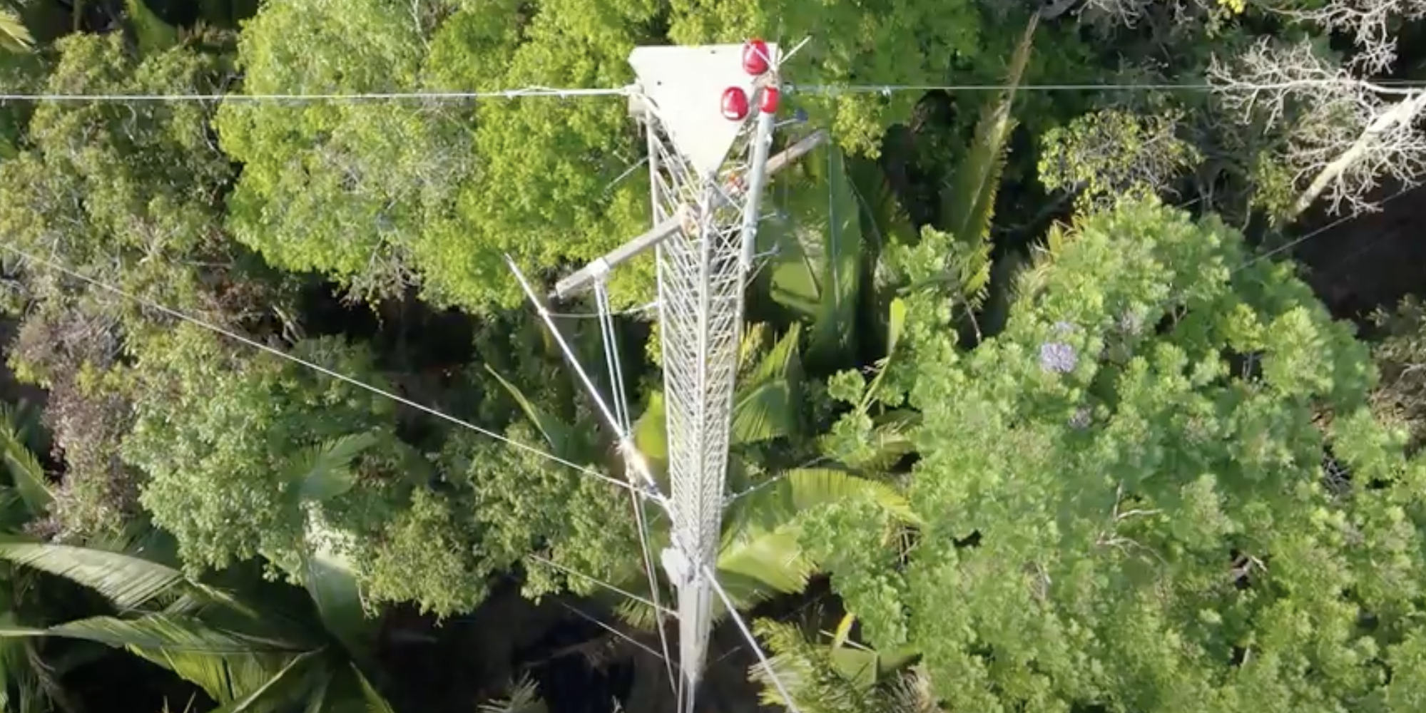
The primary forest site (LBA Tapajos KM67), is located in the Flona Tapajos Forest - a 450,000 ha closed-canopy upland forest in Amazonian Brazil. The surrounding area has minimal anthropogenic disturbance and consists of 'old-growth' forest with a stand of predominantly uneven age distribution, emergent trees, numerous epiphytes and abundant large logs.A substantial scientific installation is already present at the site which will be enhanced with additional instrumentation as part of this project.
The site forms part of the braziian space agency (INPE)-led, Large-Scale Biosphere-Atmosphere Experiment in Amazonia. Pre-existing infrastructure includes a 65m flux tower with a range of atmospheric and environmental instrumentation and a 45m high ‘walk-up’ tower which currently hosts additional instrumentation for calibration purposes and is managed by UFOPA.
New campaign-specific instruments will be installed on the 45m tower (see table 1) to complement existing meteorology and remote sensing equipment to support ground-based proximal vegetation sensing.
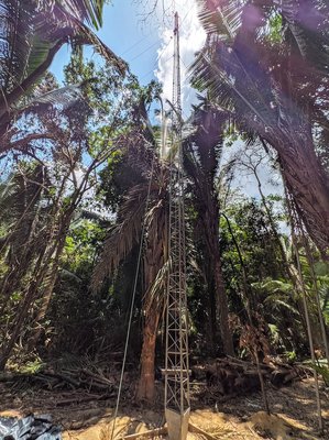
Table 1: Primary forest site: new instrumentation
| Instrument | Purpose | Manufacturer | Responsible organisation |
|---|---|---|---|
| L-Band Radiometer | VOD | TerraRadTech | TerraRadTech |
| FLoX | SIF radiance and indicies | JB Hyperspectral | JB Hyperspectral |
| GNSS | VOD | UPC | ESA |
| KT15.85 IIP thermal radiometers | LST | Heitronics | King's College |
Secondary forest site - Santarém
Secondary forest measurements will be made from an experimental farm belonging to the Federal University of Western Pará (UFOPA). It is located on the Santarém–Curuá–Una Highway (PA-370), km 37, in the municipality of Santarém, Pará State and covers an area of approximately 660 hectares with trees of up to ~47m height.
New instruments have been installed (see table 2) to complement apparatus from a number of colocated projects to this site. These include:
- SONDA Network Project (INPE – UFOPA), includes equipment related to solar and wind energy monitoring, as well as sensors for cloud cover, ozone, and ultraviolet radiation as part of INPE's national monitoring programme.
- AERONET System and Atmospheric Observatory, features a CIMEL spectrometer, allowing nighttime aerosol measurements in addition to traditional daytime measurements using solar radiation. This advancement is especially important for monitoring the increase in aerosols during the dry season, when fires are frequent in the Amazon region.
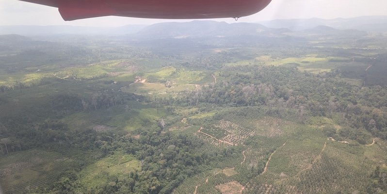
Table 2: Secondary forest site new instrumentation
| Instrument | Purpose | Manufacturer | Responsible organisation |
|---|---|---|---|
| Open path CH4 Analyser | Methane Analyser | LICOR | UFOPA |
| IRGASON | Energy Balance System | Campbell | UFOPA |
| FLoX | SIF | JB Hyperspectral | JB Hyperspectral |
| Spectrometer | Atmospheric trace gases | Pandora | ESA |
Mobile 'roving' ground based measurements
Satellite records indicate frequent fire activity - and thereby influencing variables such as GHG and aerosol emissions - around the time of the planned campaigns. Mobile ("roving") ground-based measurement equipment (see table 3) including UAVs, will be deployed around the Santarém area, guided by real-time satellite active fire detection with the aim of supplementing fire related information obtained by the airborne campaign.
Emissions factors measured close to the source on the ground can be compared to those measured from the airborne campaign to provide spatially and temporally supporting information to assess the impact of individual fire events.
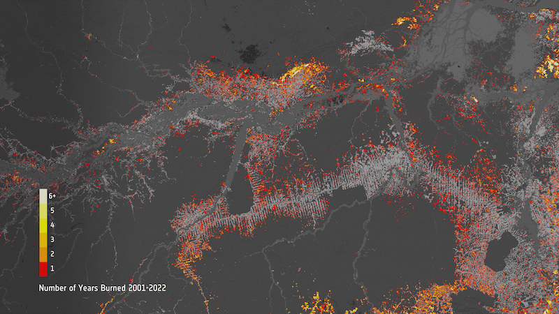
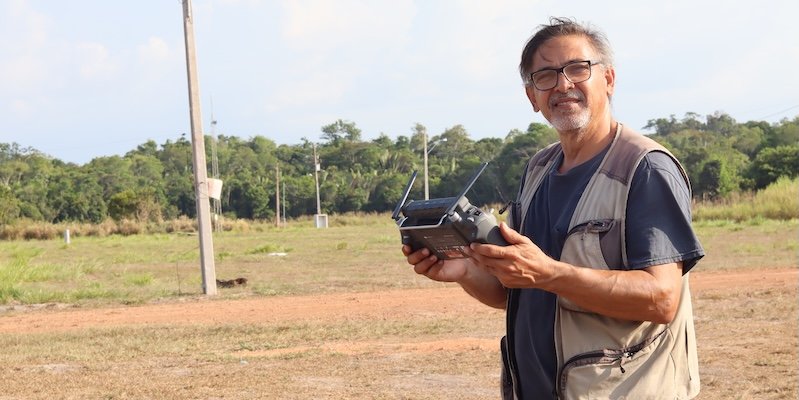
Table 3: Mobile smoke gas / particulate matter instrumentation
| Instrument | Purpose |
|---|---|
| Los Gatos Research Ultraportable | CO, CO2, CH4, and H2O |
| Aeris MIRA Pico | CO, N2O, CO2 (NDIR) |
| GasLabPro | CO2: NDIR CO: Electrochemical |
| TSI Dustrak II | Optical particulare matter analysis (0.1-10µm |
| TSI SidePak AM520 | |
| Sniffer4D mini | Particulate matter analysis PM1, PM2.5, PM10 up to 1000µm |
| Solarlight Microtops II | Aerosol Optical Depth |
The airborne component of this project greatly extends the observational coverage able to be provided by the project. It collects a series of unique datasets, but also duplicates various types of data collected from satellites and from the tower-based instruments – but now at far higher spatial detail and over far wider areas respectively. Airborne measurements include both atmospheric sampling and remote sensing, both of which help assess how representative the projects fixed tower-based observations are of the wider landscapes existing within the study area whilst also acting as a ‘zoom lens’ for satellite observations. When combined, these data will support carbon flux estimation approaches that are applied at wide scale over Amazonian landcovers, and will also help improve and validate terrestrial ecosystem models applied within the region.
Airborne operations occurred between late September and the end of October 2025, with flights over both primary and secondary forest, over deforested areas, over active fires, and sites of previous fires stretching back in some cases decades.
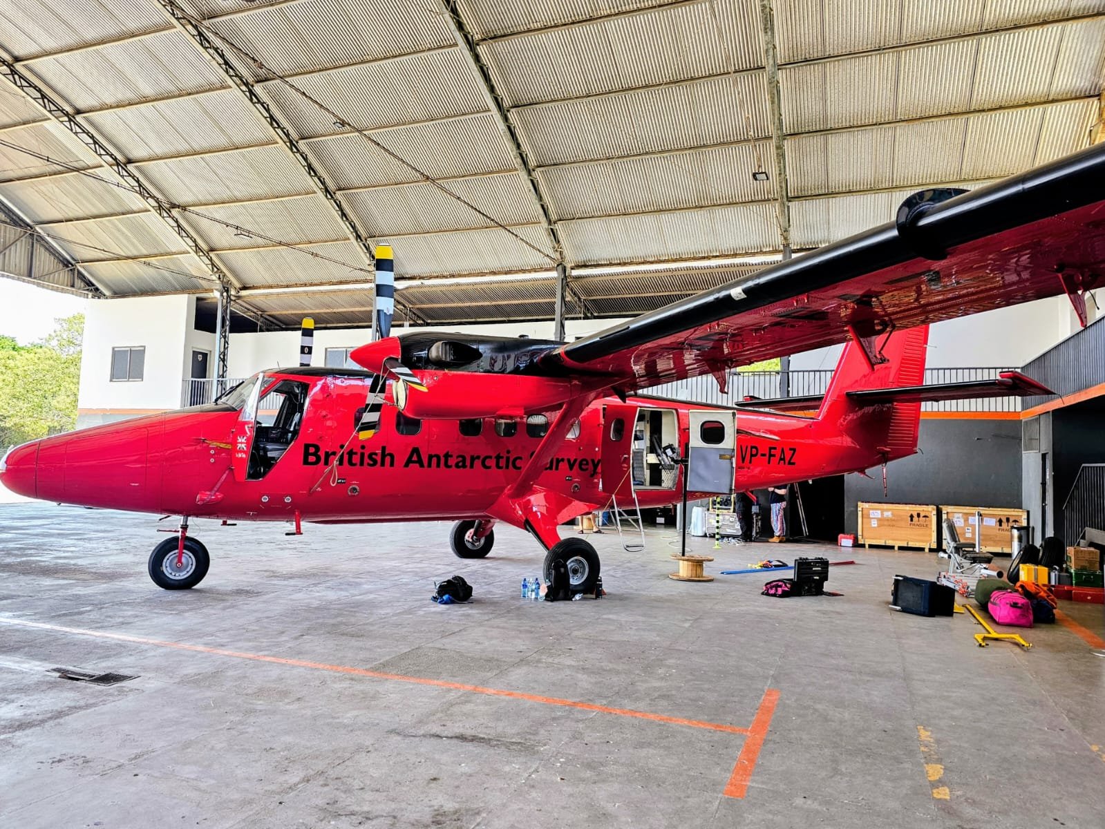
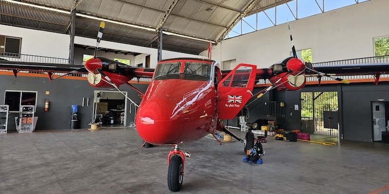
Measurements are made using the Twin Otter aircraft from the British Antarctic Survey (BAS), within which is carried a variety of remote sensing and in situ atmospheric sampling instrumentation provided mainly from King’s College London, from the UK’s National Centre for Earth Observation Airborne Earth Observatory (NAEO), and from BAS.
All airborne activity takes place within a predefined Area of Operation (AOO), agreed by the project with kind permission of the Brazilian Airforce
Airborne observations
The Twin Otter aircraft is fitted with a variety of sensors to provide its scientific measurement capability. Most of the remote sensing takes place from ~ 2.5 km above ground level, providing pixel sizes of a few metres for most of the instrumentation. These sensors can be sub-divided into those performing remote sensing and those providing in-situ atmospheric sampling surveys:
Remote Sensing Survey
Airborne remote sensing instrumentation provide data used to infer land-surface characteristics such as landcover and canopy height, as well as biophysical processes influencing GHG fluxes between the land and the atmosphere, such as canopy temperature and Solar Induced Fluorescence (SIF).
Airborne remote sensing over actively burning fires provides information on the radiative power output of the fires, the rate of combustion and the carbon flux, whilst that of the smoke using a UV-VIS spectrometer from the Royal Belgian Institute for Space Aeronomy (BIRA) provides information on certain smoke trace gas constituents - such as NO2.
In-situ sampling
In-situ sampling instruments involves collecting samples of air from outside the aircraft and measuring its constituent gases and particulates, which along with other variables such as wind speed and direction that enable certain of these concentration measures to be converted into fluxes, for example of GHGs going into and out of the forest and other land covers below.
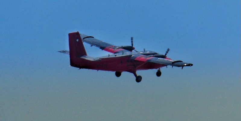
The British Antarctic Survey Twin Otter research aircraft
Core instrumentation used as part of the airborne campaign:
| Remote Sensing: | In-Situ: |
|---|---|
| Telops HyperCam Methane | MIRO MGA-10 |
| InfraTec IR8300 | DusTrak DRX/II |
| Optris PI400 / PIR uc 605 or HD Head | AlphaSense OPC |
| Specim AisaIBIS | Pressure transducer |
| SWING | PAH Sampling |
| Atmospheric Profiler |
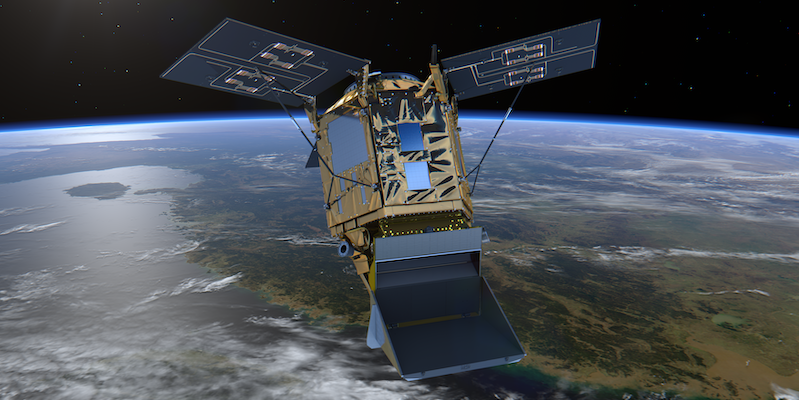
The study area and situation is characterised by existing data from Copernicus Sentinel-2, Sentinel-3, Sentinel-5P (S5P), (SMOS) and planned missions including CO2M, FLEX, BIOMASS). Additionally data from ESA Earth Explorer missions, and MetOp (ASCAT)/Metop-NG and third-party missions (AMSR-2, MODIS, PRISMA, EnMAP) will be utilised to inform the ground and air campaigns and subsequent analysis. The focus will be on L2-data from the different sources.
The interest for GNSS sensors is also motivated by next INPE’s satellite mission, Amazonia 1B/SabiaMar satellite (launch 2026 TBC), that will have a GNSS payload, with dual polarisation, dual frequency GNSS measurements, using a 2x2 antenna adapted from ESA’s HydroGNSS scout mission (it will be provided by SSTL)
The table below lists several satellites of interest. This list will likely be expanded on in the period up to the airborne campaign and details of overpass times, resolution and viewing geometry for the full airborne campaign period for each satellite will be acquired to allow efficient flight planning. The ability to carry our airborne observations concurrent with overpasses will depend on meteorological and atmospheric conditions, locations, timing and accessibility of fire activity, optimal instrument operation conditions and airport or permission restrictions.
Satellites of interest considered for validation activities.
| Satellite / Mission | Instrument(s) of Interest | Main Measurements | Orbit & Coverage |
|---|---|---|---|
| MicroCarb | NIR/SWIR spectrometer | CO₂ column concentrations (XCO₂) | Sun-synchronous, ~650 km |
| MetOp (IASI) | IASI (Infrared Atmospheric Sounding Interferometer) | Temperature & humidity profiles, greenhouse gases (CO₂, CH₄, N₂O, O₃), trace gases | Sun-synchronous, ~817 km, global twice daily |
| Sentinel-3A | SLSTR (Sea and Land Surface Temperature Radiometer) | Sea-surface & land-surface temperature, fire detection, albedo | Sun-synchronous, ~814.5 km, global every 2 days (with OLCI synergy) |
| Sentinel-3B | SLSTR | Same as above, flies in tandem with Sentinel-3A for improved coverage | Sun-synchronous, ~814.5 km |
| Suomi NPP | VIIRS (Visible Infrared Imaging Radiometer Suite) | Ocean colour, sea & land surface temperature, night-time lights, vegetation indices, aerosols | Sun-synchronous, ~824 km, daily global |
| Sentinel-5P | TROPOMI (Tropospheric Monitoring Instrument) | Atmospheric composition: O₃, NO₂, SO₂, CO, CH₄, aerosols, clouds | Sun-synchronous, ~824 km, daily global |
| Sentinel-2 (A & B) | MSI (Multispectral Instrument) | High-res optical imaging: land use/cover, vegetation | Sun-synchronous, ~786 km, 5-day revisit with A+B |
Team roles
Researchers and technical staff from King's College London, British Antarctic Survey (BAS), University of Leicester (UoL), the Belgian Space Agency (BIRA), JB Hyperspectral, TerraRadTech and the Università degli Studi di Milano-Bicocca. (UNIMIB) Europe-Brazil cooperation: Close collaboration with the Brazil’s National Institute for Space Research (INPE) and Federal University of Western Pará (UFOPA) relating to campaign planning, logistics, flight permissions and defining science objectives and observation strategies has been crucial to the preparation and implementation of the project.
Campaign involvement
- Airbone campaign: The British Antarctic Survey will provide the aircraft for the airborne activities and lead on all operational airborne matters. King's College London, BAS and BIRA will provide the airborne instrumentation.
- Ground campaign: The European Space Agency, King's College London, JB Hyperspectral, TerraRadTech, BIRA, UoL and UNIMIB will provide, install and operate fixed ground instrumentation in close collaboration with the Federal University of Para State (UFOPA) who will oversee the installation and infrastructure for these instruments
- Mobile /roving ground campaign: King's College London will provide instrumentation to enable roving observations concurrent with the airborne campaign
Project / Campaign Contacts
Science Leader: Prof. Martin Wooster | Campaign Science and Logistics Coordinator: Sarah Taylor
Project Manager: Khadijeh Rahmani
ESA Technical Officer: Dr Dirk Schuettemeyer
Lead Institution

Partners