
An update of the Small Fire Dataset of sub Saharan Africa, originally generated using data from 2016, has been publicly released by the CCI fire project.
Like its predecessor, version 2.0 of the Small Fire Dataset (referred to as FireCCISFD20) covers Sub-Saharan Africa and base burned area detection in monitoring of changes in surface reflectance resulting from biomass burning. This new product covers the year 2019, and comprises a greater image volume as it was based on the two Copernicus Sentinel 2 satellites currently operating, thus improving the temporal detection from 10 to 5 days. The improved temporal resolution improve detections, as the signal can be relatively short-lived in Tropical regions, with affected grassland areas where regrowth can be relatively rapid under favourable conditions being an illustrative example.
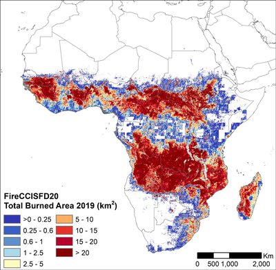
Satellite-derived maps of burned area are an important tool used to improve fire-emission inventories to quantify the impact of fires on air quality, climate and its critical component, the global carbon cycle. Actually, recent analysis of the previous FireCCISFD product published in PNAS showed that using Sentinel 2 sensors (20 m resolution) the total detected burned area increased by 80% comparing to previous estimations derived from coarser resolution MODIS data (500 m) for the same year, mostly caused by much higher sensitivity to small fires (<100 ha) that are almost undetected in global coarse resolution BA products.
The new product required an increase in processing effort (as two satellites were processed) and a slight modification of the algorithms to cope with minor orbital changes between platforms. To guide the detection of burned areas, thermal anomalies derived from the Visible Infrared Imaging Radiometer Suite (VIIRS) sensor aboard the Suomi National Polar-orbiting Partnership (S-NPP) satellite. Using the thermal anomaly that occurs when vegetation burns, the algorithm is capable of distinguishing between potential burned area patches that appear on Sentinel-2 images from other signals such as water bodies or cloud shadows.
The FireCCISFD20 dataset comprises 375,000 images approximating to 7 terabytes of data and is available at pixel resolution, with gridded data products at 0.05-degree resolution also available.
A preliminary validation of the dataset showed commission and omission errors of 7.8 and 13.5%, respectively, which are half and one third lower, respectively, than the accuracy results obtained from existing coarse-resolution products for the same area and year.
To access the data, visit the CCI Open Data Portal.