
17 de marzo de 2021
Aerosol retrieval in presence of clouds
CISAR correctly discriminates between high aerosol loads and clouds in this SLSTR scene.
Aerosol-cloud interactions play a fundamental role in climate change models, being the largest source of uncertainty in climate predictions. Aerosols act as nuclei for cloud formation and can alter cloud properties. On the other hand, cloud presence strongly affects aerosol retrievals from space observations. Non detected thin clouds can lead to a high bias in the aerosol retrieval, but aerosol increase due to swelling can also be observed tens of kilometres from the cloud borders. For this reason, cloud masks for aerosol retrievals are chosen to be conservative, to avoid any potential cloud contamination in the aerosol retrieval. Unfortunately, one of the consequences of such a conservative cloud mask is that all pixels surrounding clouds are normally discarded by both aerosol and cloud retrieval algorithms. This area, called “twilight zone”, is of high interest for studying aerosol-cloud interactions and ultimately could reduce the uncertainty surrounding these interactions in climate models.
Given the above considerations, the CISAR algorithm, developed by Rayference, has been extended to include the retrieval of cloud properties. This was feasible thanks to the CISAR scheme, which is based on the online inversion of a radiative transfer model. With the aid of temporal and spectral constraints, as well as a new source of prior information on the cloud phase and optical thickness built from satellite observations, CISAR is now able to retrieve aerosol and cloud single scattering properties without relying on a pre-processed cloud mask. This means that aerosols are retrieved continuously also in the presence of thin clouds. The new version of the CISAR algorithm has been applied to SLSTR / Sentinel-3A observations aggregated at 5 km.
In the framework of the ESA Aerosol Climate Change Initiative (Aerosol-CCI+) project, the CISAR algorithm has been applied to SLSTR / Sentinel-3A observations acquired in the visible and near-infrared bands. Figure 1 shows an example of such combined aerosol-cloud retrieval in SLSTR band S1 (0.55 mm) over Australia on the 6th September 2019. On this day CNN reported over 100 wildfires in the states of Queensland and New South Wales. Figure 2 shows a zoom of the CISAR product over these regions (left panel) and the RGB image obtained from the Ocean and Land Colour Instrument (OLCI) radiometer, also onboard Sentinel-3A. It can be observed how CISAR correctly discriminates between high aerosol loads and clouds, with continuity between cloudy and cloud free sky.
These results could open the way for a more comprehensive retrieval of Aerosol Optical Thickness (AOT), less affected by cloud contamination and enhancement and no longer dependent on the accuracy of a pre-processed cloud mask. Such an innovative product, delivering aerosol properties in the vicinity of clouds, could represent a powerful tool for studying aerosol-cloud interactions and reducing the uncertainty on future climate predictions.
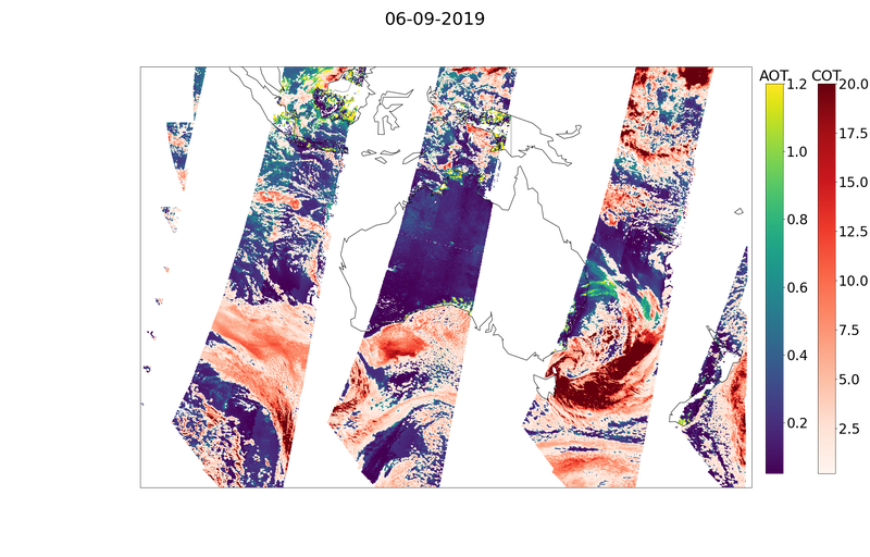
Figure 1 Aerosol (ranging from blue to yellow) and Cloud (red) Optical Thickness (AOT/COT) as retrieved by CISAR from SLSTR / SENTINEL-3A observations on the 6th September 2019 over Australia. The retrieval is performed without any pre-processed discrimination between cloudy and cloud-free pixels.
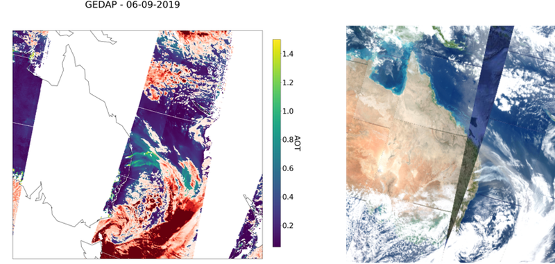
Figure 2 Zoom of the CISAR product from Figure 1 over Eastern Australia (left panel) and RGB image of the same Sentinel-3A scene obtained from OLCI. It can be seen how, without using a pre-processed cloud mask, CISAR is capable of discriminating correctly between aerosol and clouds.