
19 novembre 2025
Climate change linked to record wildfire extremes worldwide
Latest State of Wildfires report reveals human-driven warming made burned area up to 35 times larger
Extreme wildfires are no longer rare anomalies but recurring climate-driven disasters reshaping global carbon cycles. The State of Wildfires 2024-2025 report, published in Earth System Science Data, documents a fire season marked by paradox: global burned area remained below average, yet carbon emissions soared to the sixth-highest level on record since 2003. Over 8 billion tonnes of CO₂ entered Earth’s atmosphere during the March 2024 to February 2025 fire season – 9% above the long-term mean – and driven by severe fires in carbon-rich forests and wetlands across the Americas. The State of Wildfires project’s team spanning 60 institutes across 20 countries authored the report, documenting how human-caused climate change is reshaping fire regimes worldwide.
A geographic shift in fire regimes
The apparent disconnect of below-average burned area, yet sixth-highest carbon emissions on record, reflects a fundamental transformation in where fires burn. Total burned area has declined by roughly one-quarter since 2002, primarily due to reduced savannah fires in Africa, a consequence of landscape fragmentation and shifts in the seasonal distribution of rainfall. In contrast, the report finds forest fire extent has risen in the last two decades, with eastern Siberia, the western United States, and Canada each experiencing more than 40% increases in burned area.
This shift carries profound implications for the global carbon cycle. Forests and peatlands store far more carbon per unit area than grasslands, meaning that even smaller burned areas can release disproportionately large amounts. In 2024–2025 the fire emissions were driven by extremes in the Americas: emissions were more than four times above average in Bolivia, around three times above average in Canada, and roughly 50% above average in Brazil and Venezuela.
Regional fire extremes and climate drivers
The report's in-depth analyses focused on four regions of global relevance – Northeast Amazonia, the Pantanal-Chiquitano, Southern California, and the Congo Basin – identified as focal events due to the scale of their burned area, carbon emissions, and environmental impacts. All four regions experienced record-breaking fire seasons that destroyed critical ecosystems. Extreme drought, becoming more frequent and severe due to human-caused climate change, drove severe burning across the tropical regions, while Southern California saw unusually wet antecedent conditions boost vegetation growth that provided ample fuel when hot, dry, and windy weather arrived.
Evidence links climate change to extreme fires
To attribute fire to climate change the authors assessed two linked components: how climate change shifts the odds of “extreme fire weather”, defined as the worst fireweather days for each place, driven by heat, dryness, wind and little rain, and how much more area burned when those conditions occurred. The results provide clear evidence that climate change made extreme fire weather far more likely and amplified the burned area.
Northeast Amazonia saw climate change make the extreme fire weather 30–70 times more likely and increase the burned area by a factor of 4. The Pantanal-Chiquitano region experienced even more dramatic influence: climate change amplified the burned area by a factor of 35 – meaning fires burned across an area 35 times larger than would have occurred without human-caused warming. Southern California experienced climate change making extreme fire weather conditions at least twice as likely and amplifying the area burned by a factor of 25. The Congo Basin saw extreme fire weather become 3-8 times more likely, with a 2.7-fold increase in burned area.
Looking ahead, events like 2024–2025 could be up to 57% more frequent in the focal tropical regions by 2100 under a medium–high emissions pathway, but increases stay below 15% with strong mitigation, demonstrating that climate action can substantially reduce future fire risk.
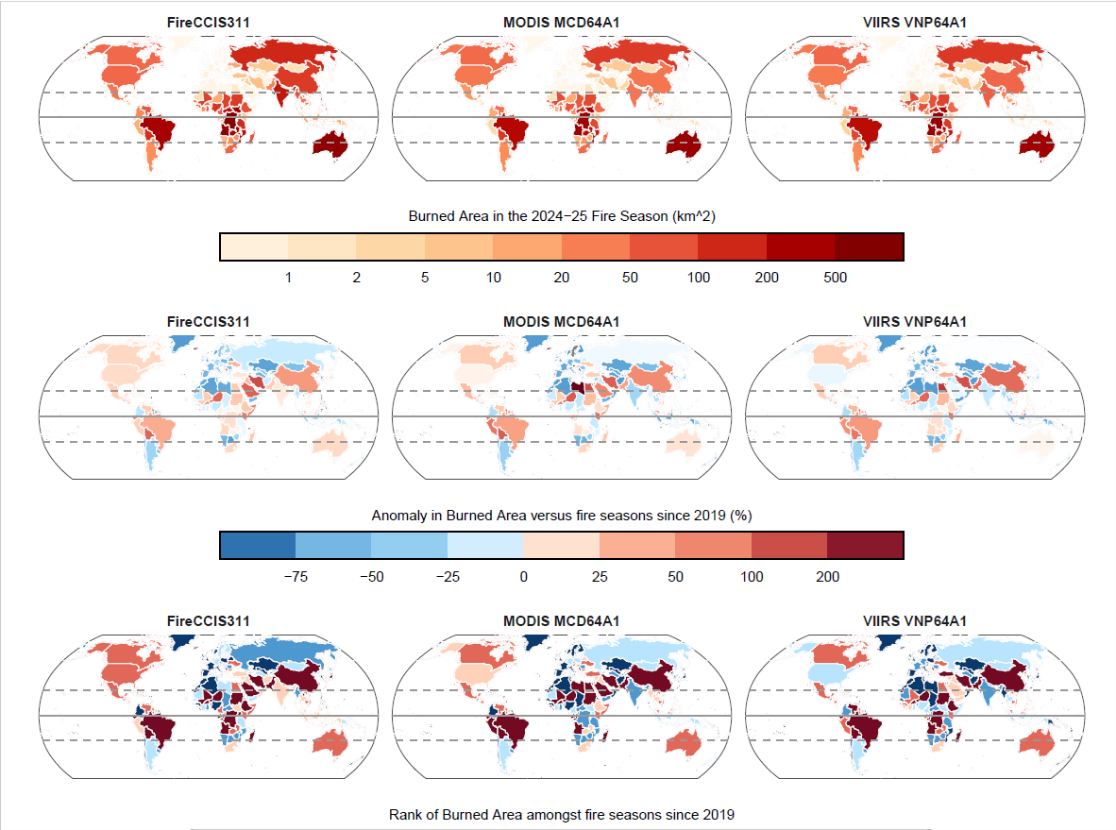
Validating global fire observations from space
Long-term satellite records, including ESA's Climate Change Initiative (CCI) were instrumental in independently verifying the report's burned area findings. Scientists compared ESA's FireCCIS311 dataset – derived from Sentinel-3 satellite observations at 300-metre resolution – side-by-side with NASA's MODIS and VIIRS products to benchmark burned area estimates and quantify uncertainty.
This multi-product cross-check confirmed that the extreme fire patterns observed in 2024-2025 are robust across different satellites and detection methods. The FireCCI project also revealed an important limitation, based on previous analyses: coarser satellite products can miss a substantial share of small fires. In Sub-Saharan Africa, for example, medium-resolution products (250 m) detected only about half the fires identified by high-resolution Sentinel-2 imagery (20 m). However, long-term trends and variability remain consistent across products, ensuring reliable climate analysis. FireCCIS311 provided independent evidence that strengthened confidence in the magnitude and distribution of burned area anomalies reported for 2024-2025.
Building on these insights, the FireCCI team has developed FireCCI60, a new dataset that harmonises global observations from 2003 to 2024 and will continue to be processed into the future. This homogenised record ensures that fire trends can be tracked consistently across two decades of satellite observations, providing a robust long-time dataset to improve the analysis for the next State of Wildfires report. Complementing this effort, a new high-resolution dataset based on Sentinel-2 observations is nearing completion. This dataset will deliver global burned area maps for 2023 at 20-metre resolution. At this scale, many small fires invisible to medium-resolution satellites become detectable, further enhancing the ability to monitor fire activity worldwide.
"ESA delivers the observational foundation needed to better understand extreme fire patterns; we allow not only to detect fires when they occur, but also to anticipate future fire and enable early warning systems to predict fire seasons before they unfold", says Clement Albergel, Head of Actionable Climate Information at ESA. "By combining consistent satellite data such as burned areas and active fires with weather forecasts, we're moving from documenting what has burned to enable predicting when and where the next extreme fire season is likely to strike.”
Implications for climate policy and the Paris Agreement
The record fire emissions during the 2024-2025 fire season underscore a critical challenge: wildfires are both a consequence and accelerating driver of climate change. These emissions are not fully accounted for in national inventories or Paris Agreement commitments but help to reflect real-world conditions.
As world leaders meet in Belém, Brazil, for COP30, the message is clear: global emissions must fall rapidly, or wildfire risk will escalate for generations. Strong mitigation can effectively contain future fire risk, while higher-emissions pathways can lead to dramatically increased fire frequency and severity across carbon-rich ecosystems worldwide.
Kelley, D. I. et al.: State of Wildfires 2024–2025, Earth Syst. Sci. Data, 17, 5377–5488, https://doi.org/10.5194/essd-17-5377-2025, 2025.