The SATACI project is a science exploitation study which utilises multiple Essential Climate Variable data products developed via ESA's Climate Change Initiative (CCI) to improve understanding the climate system that are directly relevant to IPCC assessments.
The objective of SATACI objective is to deepen understanding of Aerosol-Cloud interactions and the associated Radiative Forcing, capitalising on the heritage from the ESA Climate Change Initiative aerosol and cloud projects and state-of-art algorithms for the consistent retrieval of aerosols and clouds. Two main activities will be performed during this three-year study:
- Aerosol-Cloud (ACI) analyses from satellite data to tackle aerosol indirect effects on liquid clouds as well as the relationship between dust concentration and cloud glaciation temperature
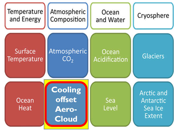
- Feasibility study for a new aerosol-cloud climate indicator to monitor the cooling effect of ACI on the climate and complement existing WMO Climate Indicators.
Aerosol-cloud analyses from satellite data
ACI analyses will use data from geostationary and polar-orbiting satellites to study the impact of aerosols on clouds at different spatial and temporal resolutions, relying on previous efforts to expand the retrieval of aerosols in the vicinity of clouds. Two scientific studies will be undertaken to develop the analysis methods:
- Scientific Study I: Analysis on aerosols' indirect effect on liquid clouds. This work relies on aerosol and cloud datasets obtained with the CISAR and ORAC retrieval algorithms. External datasets could be included, as necessary, to mitigate limitations in the retrieval from the retrieval algorithms. Statistical analysis of aerosol-cloud relations will be carried out considering proxies for aerosols and clouds such as AOD and CDNC.
- Scientific study II: Cloud glaciation temperature and dust concentration. This study is investigating the sensitivity of the cloud phase occurrences to dust concentration, the dominating INPs initiating cloud glaciation (Han et al., 2023) for sub-zero temperatures above -38°C (heterogeneous freezing). This study will exploit aerosol and cloud data including dust or coarse mode aerosol optical depth, aerosol layer height, clout top temperature and cloud phase, available through cloud-CCI and Copernicus Climate Change Service (C3S) datasets.
Two feasibility studies will be performed to ensure that the proposed methodology is appropriate. Methods to repeat the statistical analysis at different temporal and spatial resolutions; and to test the usefulness of the outcome of these studies will be proposed, using the Norwegian Earth System Model (NorESM) model (Seland et al., 2020) - a state-of-the-art CMIP6 class model. Adaptations need to be implemented to increase, for instance, the output frequency, and - eventually - simulate satellite observations to ensure more consistent comparisons.
Feasibility study for a new aerosol-cloud climate indicator
A feasibility study to derive a new aerosol-cloud climate indicator will be performed within this proposal, aiming at delivering a new tool to monitor the cooling offset due to aerosols and clouds and complement the existing World Meteorological Organisation (WMO) indicators.

This activity aims to visualise the greenhouse gas warming concealed by aerosols and clouds developing a new climate indicator ‘aerosol / cloud cooling offset’. This aerosol overall cooling has contributions by direct (aerosol presence) effects and by indirect effects - mainly through aerosol modified water clouds. Global, long-term satellite data records will be used to demonstrate the feasibility of a method to derive a new climate indicator which enables monitoring the cooling offset due to (anthropogenic) aerosols and (aerosol modified) clouds. This new indicator would complement the existing WMO climate indicators based on off-line (dual call) two-stream radiative transfer simulations Kinne, 2019.
Consistency Study
The two activities will run in parallel and culminate in a synthesis work package where the statistics obtained from regional satellite observations (Activity I) will be compared with the climate indicator results for overlapping regions/periods. To support this exercise, a singular vector decomposition (SVD) will be performed, to compare the temporal evolution of various spatial modes/patterns in the climate indicator and cloud/aerosol property time series. This should reveal which aerosol and cloud properties are driving the value of the indicator. Furthermore, the SVD analysis can be exploited to investigate possible correlation between the new climate indicator and the existing WMO indices. The radiative effect calculations performed on the ensemble of Level-3 products used within Activity 2 will be compared with the values obtained averaging and regridding the fluxes calculated using Level-2, to assess the impact of spatial and temporal regridding.
The proposed approach will investigate the consistency between observational evidence obtained from available datasets of aerosols and clouds and the model predictions, trying to improve our knowledge on aerosol-cloud interaction and their radiative impact on the Earth’s climate.
Marta Luffarelli, Rayference, SATACI Science Leader
Marta Luffarelli is the Managing Director of Rayference, which goal is to develop innovative solutions for Earth Observation. In her current position, she oversee the strategic vision, business development, and operational management of the organization. She have a strong background in remote sensing, with a PhD in Physics from Université libre de Bruxelles and more than 8 years of experience as a remote sensing scientist at Rayference, working on several European and international projects, applying her skills in scientific research, coding, and technical writing. She will manage the SATACI project and lead the Scientific Study I (aerosol indirect effect on liquid clouds) within Activity I.
Elisa Carboni, RAL Space, Research Scientist,
Elisa Carboni is a Research Scientist at Remote sensing group - RAL space. Within SATACI, She will support the analysis of consistency/differences between satellite dataset and models with a singular vector decomposition (SVD) analysis and support the quantification of the impact of using Level-2 or Level-3 data through radiative fluxes calculations.
Yves Govaerts Rayference SRL, Scientific Advisor
Yves Govaerts is administrator and scientific advisor at Rayference, the company he funded in 2013. His extensive knowledge and expertise is applied to the remote sensing of aerosols, clouds and surface reflectance, as well as cal/val activities and metrology. He will act as Scientific Advisor within the SATACI project.
Jan Griesfeller, Norwegian Meteorological Institute, Research Scientist
Jan Griesfeller will support the interfacing of the constraints obtained from satellite observation with the NorESM model within the SATACI project and provide scientific support.
Thomas Holzer-Popp DLR Senior Scientists
Thomas Holzer-Popp is a Senior Scientist at the German Aerospace Center (DLR). He is the Science Leader of the Aerosol CCI projects. Within the SATACI project, he will lead Activity II, the feasibility study of a new aerosol-cloud climate indicator.
Stefan Kinne, Retired. Previously Max-Planck-Institute for Meteorology,Senior Scientist
Stefan researches Atmospheric and environmental sciences, Aerosols, Meteorology, and AERONET.
Nicolas Misk, Rayference SRL, Research Engineer
Nicolas Misk is a Research Engineer at Rayference, specializing in radiative transfer and remote sensing technologies. He plays a key role in developing and maintaining tools for comparing Radiative Transfer Models (RTMs) using Python in a distributed environment. He is currently a PhD candidate at the Q-Forestlab of Ghent university. Within SATACI he is the WP leader on the uncertainty characterisation and propagation within scientific study 1.
Daniel Robbins, RAL Space, Remote Sensing Scientist
Michael Schulz, Norwegian Meteorological Institute, Senior Scientist
Michael Schulz is Deputy Head of Climate Modelling and Air Pollution at the Norwegian Meteorological Institute and Adjunct Professor at MetOs UiO Geosciences. He focuses on atmospheric science, climate forcing, feedbacks, and aerosol physics in Earth Systems. Schulz advances model development by leading intercomparisons like CMIP6-AerChemMIP and AeroCom and contributes to EU Copernicus CAMS projects. He oversees NorESM development at the Norwegian Meteorological Institute and aims to enhance Earth System understanding of near-term climate change. Within the SATACI project, he will integrate satellite-based constraints with NorESM and provide scientific support.
Martin Stengel, Deutscher Wetterdienst,Senior Scientist
Martin Stengel is a Senior Scientist at Deutscher Wetterdienst and he is the Science Leader of the Cloud CCI project. He will lead the Scientific Study II on dust concentration and ice cloud glaciation within Activity I.
Gareth Thomas, RAL Space, Senior Remote Sensing Scientist
Gareth has over 10 years of experience in aerosol and cloud remote sensing from satellites. He develops and uses algorithms, like the ORAC retrieval scheme, to analyze atmospheric aerosols from visible/infrared instruments. He produces large-scale datasets for climate monitoring, air quality, and environmental studies, including for the ESA Climate Change Initiative. Within the SATACI project, he will support the fit-for-purpose exercise, uncertainty characterization, and provide ongoing scientific input.
- Science Leader: Marta Luffarelli
- ESA Technical Officer: Michael Eisinger
Latest news & events

CCI colocation & CMUG integration meeting 2026
Annual gathering of the CCI community for ESA programme updates, scientific progress, and forward-looking discussions.
Meer leren

Working for ESA: procurement and proposal submission process
An Introduction to ESA Star - ESA's System for Tendering and Registration
Meer leren
ESA at COP29
ESA is participating in COP29 to highlighting satellites' role in tackling climate change
Meer leren

SATACI at the 23rd AeroCom / 12th AeroSat workshop
Introducing SATACI at the 23rd AeroCom / 12th AeroSat workshop
Meer leren

