
Access the full suite of ESA Climate Change Initiative data products via our dedicate Open Data Portal, including those generated by the CCI Sea Surface Temperature project.
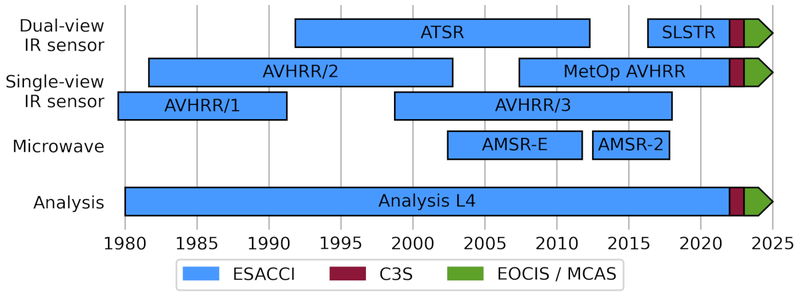
The SST-CCI Climate Data Record (CDR) provides global SST in the period 1980 though 2021 derived from three series of thermal infra-red sensors: the Advanced Very High Resolution Radiometers (AVHRRs), the Along-Track Scanning Radiometers (ATSRs), and the Sea and Land Surface Temperature Radiometers (SLSTRs); and two microwave sensors: the Advanced Microwave Scanning Radiometers (AMSR). The data have been extended since 2022 in the form of an Interim CDR (ICDR) providing an ongoing extension at short delay (approximately 2 weeks behind present). The ICDR was funded by the Copernicus Climate Change Service (C3S) for 2022 and is now funded by the UK Earth Observation Climate Information Service (EOCIS) and UK Marine and Climate Advisory Service (UKMCAS) for 2023 onwards.
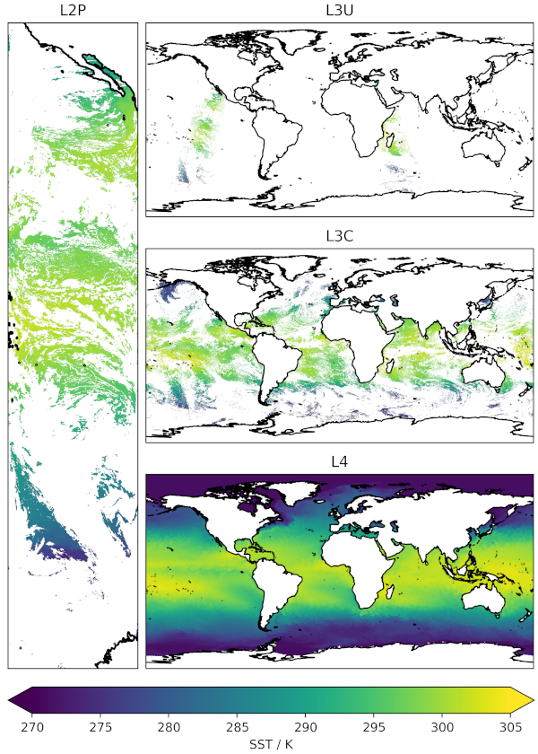
The following data products are available: single-sensor products at their native resolution (Level 2P), single-sensor products remapped to a 0.05° regular latitude-longitude grid (Level 3U), single-sensor products collated into daily files (Level 3C), and a daily gap-free product which combines data from all sensors (Level 4). Data from the infra-red sensors are provided in all three single-sensor levels (Level 2P, Level 3U, and Level 3C), while the microwave AMSR products are only available at level 2P as the native resolution of the AMSR sensors is lower than the 0.05° grid used for Level 3.
Licence
SST CCI data are licensed under the Creative Commons Attribution 4.0 International licence (CC-BY 4.0). This allows the data to be used by any user for any purpose, under the condition that the data are correctly attributed. Users of the data should quote the correct name and version for the dataset in use (as listed in the data pages), and cite the peer-reviewed article describing the Climate Data Record:
Embury, O., Merchant, C.J., Good, S.A., Rayner, N.A., Høyer, J.L., Atkinson, C., Block, T., Alerskans, E., Pearson, K.J., Worsfold, M., McCarroll, N., Donlon, C., (2024). Satellite-based time-series of sea-surface temperature since 1980 for climate applications. Sci Data 11, 326. doi: https://doi.org/10.1038/s41597-024-03147-w
Current Products
Most users want the Level 4 SST CCI analysis product which combines observations from all sensors to produce a global, gridded, gap-free estimate of daily mean SST. However, the gap-filling interpolation does degrade feature resolution, which varies with location, but is typically coarser than 15 km (compared to the grid resolution of 0.05°).
Data may be downloaded from the CEDA archive at ESA SST CCI CDRv3 collection. Or specific datasets from:
- ESA SST CCI Analysis v3.0 - includes ongoing ICDR extension
- ESA SST CCI Climatology v3.0
- ESA SST CCI AMSR L2P v3.0
- ESA SST CCI AVHRR L2P v3.0
- ESA SST CCI AVHRR L3U v3.0
- ESA SST CCI AVHRR L3C v3.0 - includes ongoing ICDR extension
- ESA SST CCI ATSR L2P v2.1
- ESA SST CCI ATSR L3U v2.1
- ESA SST CCI ATSR L3C v2.1
- ESA SST CCI SLSTR L2P v3.0
- ESA SST CCI SLSTR L3U v3.0
- ESA SST CCI SLSTR L3C v3.0 - includes ongoing ICDR extension
Previous Versions
Older versions of the Climate Data Records are available from CEDA catalogue and the CCI Open Data Portal