
27. August 2025
Satellites reveal hidden climate vulnerabilities of sub-Sahelian lakes
Study sets baseline for climate-related research on 137 freshwater ecosystems
Across sub-Sahelian Africa, lakes play a crucial role in maintaining biodiversity and supporting the livelihoods of millions of people. According to the latest report by the Intergovernmental Panel on Climate Change (IPCC)*, five out of nine key risks facing Africa are related to the deterioration of freshwater resources, increasing demand, and sensitivity to extreme climate-related events, yet most of these lakes have not been studied in much detail. To fill this knowledge gap, an international research team has compiled an open-access map for 137 natural lakes and reservoirs including how water quality and quantity respond to climate and human pressures. It offers unparalleled spatial coverage of the region. The long-term, global view of satellite data from the European Space Agency's Climate Change Initiative (ESA CCI) provides a unique opportunity to expand studies from single-lake in-situ investigations to a regional or even global scale, identifying large-scale influences under a changing climate. The findings present a much-needed benchmark for monitoring, policy-making, and future research, helping to prioritise lakes and regions most at risk.
The study integrates satellite-derived lake observations for key climate and ecologically important variables including water temperature and level, chlorophyll-a concentration – which is a proxy of algae presence – turbidity (water cloudiness) and colour. These are integrated with atmospheric factors such as rainfall and air temperature, and human factors like land use and population density. In combination these data enabled the scientists to analyse the seasonal cycles of each lake and determine the times of year when they are warmest, when water levels peak and when algal blooms occur, as well as identifying the major drivers of water quality.
Identifying the drivers affecting lake behaviour is crucial as growing human settlements near lakes increase water demand for industrial, agricultural and energy uses, while inadequate wastewater treatment infrastructure allows uncontrolled pollutant inflows that degrade water quality and threaten public health.
Identifying seasonal patterns to pinpoint lake-climate risks
Researchers assessed the responses of the region’s lakes to rainfall, temperature, wind, and human pressures. By analysing the climatological patterns, the researchers can see how clusters of ‘similar’ lakes respond to regular, predictable changes in their environment, separate from unusual events or one-off weather extremes. Each cluster exhibited a distinct profile of climate vulnerability, identifying which lakes are most sensitive to seasonal climate drivers. In numerous natural tropical lakes, included in the study, peaks in rainfall corresponded with increases in water level, surface water temperature and turbidity, as captured by ESA CCI lake records. In contrast, rainfall had a weaker or delayed effect in arid lakes with wind emerging as the dominant climatic driver. These differences reflect the influence of local climatic regimes on seasonal lake dynamics. While the study shows that lakes do not respond uniformly, identifying these patterns is essential for anticipating which systems are most at risk as climate change progresses, according to the study authors.
As the region’s climate changes shifts in the timing and intensity of rainfall, increase temperature extremes, and create fire-prone weather conditions are expected, all of which have the potential to disrupt the seasonal patterns of water quality parameters in lakes.
"This study sheds new light on the state of freshwater resources in sub-Sahelian Africa by focusing directly on the lakes themselves, rather than only on surrounding hydrology or rainfall patterns. It raises awareness of the urgent need to monitor water quality in these vital ecosystems," says lead author Marina Amadori, post-doctoral researcher at the Institute for Electromagnetic Sensing of the Environment at National Research Council of Italy.
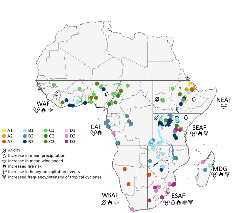
The map shows the key results of the study: The clusters of lake functioning based on the analysis and correlation with lake variables. Acronyms indicate regions defined in the Intergovernmental Panel on Climate Change report: North East Africa (NEAF), South East Africa (SEAF), Madagascar (MDG), East South Africa (ESAF), West South Africa (WSAF), Central Africa (CAF) and West Africa (WAF). Icons depict the climate change vulnerability in the African regions.
Laying the groundwork for future research
The study establishes the first comprehensive baseline for Africa's water resources, providing a foundation for future climate research. It supports the management and protection of African lakes in the context of climate change, while also contributing to global adaptation strategies for freshwater ecosystems.
Find the paper here: https://www.nature.com/articles/s43247-025-02684-5
* Niang, I. et al. Africa. In: Climate Change 2014: Impacts, Adaptation, and Vulnerability. Part B: Regional Aspects. Contribution of Working Group II to the Fifth Assessment Report of the Intergovernmental Panel on Climate Change. (Cambridge University Press, 2014).