Satellite-based Earth observation can play a critical role in all stages of climate adaptation monitoring, as a comprehensive new study demonstrates. Climate adaptation refers to actions that help communities, ecosystems, and infrastructure adjust to current and future climate impacts – such as building flood defences and developing drought-resistant crops as well as creating green spaces in cities to tackle extreme heat.
Satellites can track all stages of this process: from hazard mapping and risk assessment to perhaps most critically, evaluating whether protective measures actually work. To reach this conclusion, researchers led by Sarah Connors, Climate Applications Scientist at ESA, examined which of the Paris Agreement's Global Goal on Adaptation (GGA) targets could be supported using satellite data. For decades now, Earth observation satellites have been monitoring the most critical changes to the Earth’s climate system, known as Essential Climate Variables (ECVs). ESA's Climate Change Initiative (CCI) is a major research and development effort that generates global, decades-long satellite data records to track and understand these changes.
This new study finds that many of these ECVs can be directly used to understand and support climate adaptation action. Focusing on four key sectors – agriculture, biodiversity, extreme events, and health – it reveals how space-based data offers something no other monitoring system can provide: truly global coverage with objective and repeatable measurements spanning up to 60 years. The publication of the paper coincides with the Conference of the Parties (COP30), at which negotiators at the United Nations climate summit in Belém, Brazil, are expected to finalise a list of indicators to measure progress towards the GGA.
The urgent need to track adaptation progress
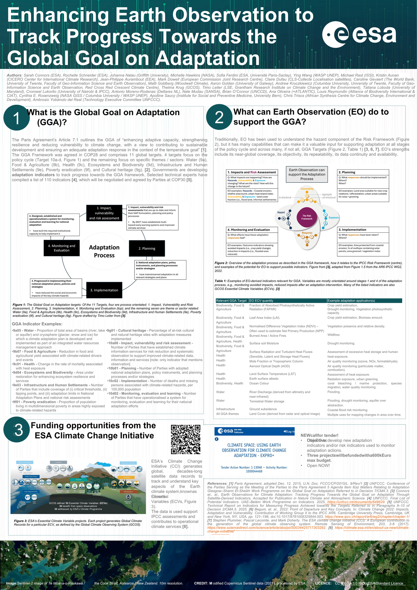
As climate change accelerates, driving more frequent extreme events, rising sea levels, and shifting ecological zones, the need for communities to adapt has become universal. The Paris Agreement’s GGA aims to enhance adaptive capacity, strengthen resilience, and reduce vulnerability to climate change. But to ensure these efforts are effective, the international community must be able to track progress – a challenge that has sparked an ambitious effort to develop systematic indicators. At the Conference of the Parties in 2023 (COP28), governments adopted a framework comprising eleven concrete adaptation targets covering key sectors including water, agriculture, health, ecosystems, infrastructure, poverty reduction and cultural heritage. To track progress towards these goals, governments and organisations submitted over 7,500 potential indicators in 2024, which technical experts refined to approximately 100 indicators to be finalised at COP30 in Brazil this year.
“Creating the first systematic framework for measuring adaptation success worldwide requires consistent, large-scale data that can track progress across vastly different geographic contexts,” explains Connors, who manages many of the ocean-related ECV projects at ESA as part of the CCI and leads the agency’s work on how Earth observation can support climate change adaptation. “This is where Earth observation becomes increasingly critical, as it is able to offer global spatio-temporal continuity of observations.”
Satellite capabilities for adaptation indicators
For the GGA framework to succeed, it needs data sources that can deliver at a truly global scale. Earth observation (EO) offers manifold strengths: of the 55 Essential Climate Variables currently defined by the Global Climate Observing System (GCOS), around two-thirds can already be directly monitored with satellite data, providing a foundation from which adaptation indicators can be derived. Beyond this breadth, satellites provide objective, repeatable measurements adhering to strict quality standards, with comprehensive coverage including remote and inaccessible areas where adaptation is often most needed. Crucially, the satellite data record now spans several decades, providing the long-term continuity essential for establishing baselines and detecting climate-driven changes. ESA’s CCI has been developing these capabilities for over 15 years, creating comprehensive datasets covering Essential Climate Variables such as Sea Level Rise, Land Surface Temperature, Biomass, and Ozone.
The research of Connors and her colleagues demonstrate concrete applications across four key GGA themes: In agriculture, satellites monitor water productivity, irrigation efficiency, and crop migration patterns. For biodiversity conservation, platforms like Global Mangrove Watch and Global Forest Watch provide crucial geospatial information on ecosystem extent and changes. When it comes to extreme events, satellites characterise flood extent, drought anomalies, and urban heat islands at scales impossible with ground-based stations alone. Meanwhile, in the health sector, Earth observation data on land surface temperature and air quality inform heat exposure assessments and disease outbreak forecasting.
Learning from the Sustainable Development Goals
Drawing parallels with the Sustainable Development Goals (SDGs), where only 17 of the 232 SDG indicators can currently use Earth observation as a major data source, the study urges the GGA process to leverage satellite data more systematically from the outset. The researchers recommend establishing standardised, operational EO-based adaptation indicators similar to how the GCOS established robust monitoring for ECVs.
“Earth observation data should be considered as an integral part of the GGA indicators,” argues Connors. “Our research demonstrates that satellite data can inform adaptation tracking across many sectors, but it must be integrated into the indicator framework from the outset – as experience with the Sustainable Development Goals shows, it’s much harder to introduce later.”
As climate change accelerates, a satellite-based monitoring system offers an opportunity to ensure that adaptation efforts deliver tangible results for the communities that need them most, transforming climate resilience from an aspiration into a measurable reality.
The paper “Earth observations for climate adaptation: tracking progress towards the Global Goal on Adaptation through satellite-derived indicators” is an outcome of the Forum “Using Earth Observation Systems to Improve Climate Adaptation Policy and Action”, held at and funded by the International Space Science Institute (ISSI) in Bern, Switzerland on 25–28 of June 2024.