
14 avril 2022
Snow climate data record update boosts accuracy
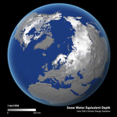
Satellite-derived snow mass estimates track seasonal snow pattern
Snow is an important element of the global climate system, covering around half of the northern hemisphere land area at its winter peak. The most accurate satellite-derived record to date, spanning over 40 years was recently released by the ESA Climate Change Initiative Snow project, to better understand how this important element of the earth system is responding to climate change.
The newly released dataset, known as Snow CCI+ SWE Version 2 (CCIv2) and reported in the journal Remote Sensing of the Environment, details change in northern hemisphere snow water equivalent (SWE) between 1979-2020. Snow water equivalent is the depth of water produced if the snow cover melts completely. Knowing how much water is stored in the seasonal snowpack is critical for water resource management including flood and drought predictions. Long-term records of snow water equivalent at the global scale are critical to understanding the influence of climate change.
Snow’s high albedo, thermal insulation properties, and the contribution its meltwater makes to soil moisture and runoff, make it an important part of the Earth system. Snow is one of only 54 variables required by the UNFCCC to characterise the climate, with earth observation satellites crucial to monitoring snow cover at the regional to global scale.
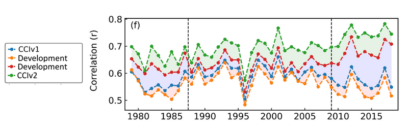
The new satellite-derived dataset was found to agree more closely with surface snow measurements, with accuracy improving by almost one-fifth when compared to previous versions. The authors also show that the timing of the peak snow mass in the improved dataset new dataset is shifted two weeks later when compared to the previous dataset. This shift puts the peak snow mass more in line with estimates from other SWE datasets of when peak snow mass should occur.
According to lead author of the study, colleen Mortimer, “Satellite-derived snow mass estimates play an important role in documenting how seasonal snow is responding to climate change. Understanding changes to this important freshwater resource is necessary to inform future adaptation to a changing climate.”
Improving satellite datasets
The new data were produced as part of ESA’s Climate Change Initiative, which generates accurate and consistent long-term data records for key aspects of the climate by merging and information from multiple satellite missions. This collective research and development effort results in robust and consistent datasets with fully characterised uncertainties, validated using independent, traceable, in-situ measurement. Used to systematically observe the climate, these data support scientists and the UNFCCC to understand earth system changes, support model development, and are a key input to climate services used to address mitigation and resilience.
SWE is estimated from satellites using passive microwave observations from sensors including the Special Sensor Microwave/Imager (SSM/I) to the Special Sensor Microwave Imager/Sounder (SSMIS).
The improved dataset accuracy and consistency was achieved by moving to newer reprocessed and enhanced resolution passive microwave information and incorporating in-situ snow density measurements. Adopting NASA’s MEaSUREs Calibrated Passive Microwave Daily EASE-Grid 2.0 Earth Science Data Record, the 12.5 km grid spacing delivered a 50 percent spatial improvement when compared to the heritage datasets. Previous versions of the SWE dataset assumed a constant snow density that remained static over time and location. In the new product, snow density estimates vary by location and evolve over the snow season to more accurately reflect the changing snow conditions on the ground.
Artefacts in the time-series, that can occur when the satellite instruments used to estimate snow water equivalent are changed have been removed, improving the suitability of the dataset for climate change studies and underlining the importance of ongoing R&D on historic satellite data to improve robust retrieval algorithms and the resulting climate data records.
Reference
C. Mortimer, et al (2022) Benchmarking algorithm changes to the Snow CCI+ snow water equivalent product, Remote Sensing of Environment. https://doi.org/10.1016/j.rse.2022.112988.
Snow CCI project
https://climate.esa.int/en/projects/snow/about/
Access Snow_cci datasets
https://catalogue.ceda.ac.uk/uuid/93cf539bc3004cc8b98006e69078d86b