
17. Juni 2022
Land surface temperature datasets now available
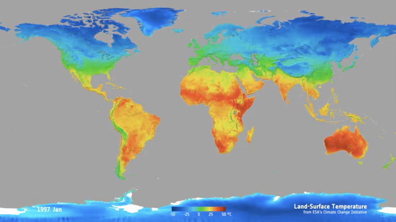
This new 25-year record combines measurements from different infrared and microwave sensors to give a global view
New land surface temperature (LST) datasets from the ESA-funded Climate Change Initiative (CCI) LST project (LST_cci) provide measurements from different sensors to give a global view. The datasets are based on both infrared and microwave satellite sensors onboard polar-orbiting and geostationary platforms. A key feature of the LST_cci project is the provision of multiple LST datasets that have been processed using a consistent approach and delivered in a common format.
Although satellite-derived temperature analysis is well established, these new datasets, which currently span the period 1995-2021, provide LST observations that will be used to gain a more comprehensive understanding of environmental change.
LST is one of 54 Essential Climate Variables (ECVs) defined by the Global Climate Observing System (GCOS) to monitor climate change.
“LST is integral to the radiative energy budget of the Earth’s surface, and it provides the best approximation of the thermodynamic temperature that drives the surface energy,” says Dr Darren Ghent, who leads the research as part of ESA’s Climate Change Initiative.
Ghent adds, “Our project provides independent temperature datasets for quantifying climate change, complementing the near-surface air temperature ECV based on in situ measurements and reanalysis – it is being used to fill gaps in the analysis of near-surface air temperature, to improve our understanding of the climate in station-sparse regions, and to extract higher resolution information. This greatly increases scientists’ ability to monitor climate change as satellites have the potential to observe the whole Earth every day, whereas the coverage of temperature records from ground-based weather stations can be patchy in some regions. For example, in polar regions where climate change is happening very quickly and in developing countries where the vulnerability of local populations can be high”.
The datasets are accompanied by an objective assessment of their accuracy and have been validated against high-quality ground based LST observations across a range of sites. Where the length of the LST_cci data record permits, the temporal stability of the datasets has also been evaluated and reported.
“LST is relevant to many climate applications. For example, the records can be applied to our understanding of urban heat islands and urban planning to map and henceforth mitigate heat stress,” says Ghent, “and we can distribute these findings to decision makers at the national and local level to address issues such as vulnerability, urbanisation, and green space designation. Given that over half the world’s current population live in urban areas, this application of LST has the potential to have a very high impact on human health and wellbeing.”
Other applications for the LST data include agricultural and water management, tracking geothermal anomalies, and monitoring changes in the cryosphere.
In addition to providing datasets based on single satellite sensors, the LST_cci project is carrying out pioneering work to develop LST datasets that combine observations from multiple satellite sensors. This includes a product that blends consistent, global infrared (IR) data at 1 km spatial resolution from polar-orbiting satellites, which typically provide one or two observations per day per sensor, with LSTs from geostationary satellites that provide regional LSTs from IR data up to every 15 minutes but at a lower spatial resolution. The result is a global 0.05° latitude-longitude, 3-hourly ‘merged product’ that can be used in a very wide range of applications.
In the future, a product combining infrared and microwave LSTs will also be available for a single year, as a demonstration of the synergy between these two types of sensors. Microwave sensors provide near all-weather LST observing capability, whereas infrared sensors can only observe LST under cloud-free conditions but have a better accuracy and higher spatial resolution compared with microwave-observed LSTs. Therefore, the resulting merged product will provide near all-weather LSTs but with improved accuracy and spatial resolution compared with a microwave-only LSTs.
The LST_cci datasets are freely available from the CCI Open Data Portal.