
Ocean waves, influenced by surface winds, potentially endanger offshore infrastructure and threaten low-lying ecosystems and communities due to coastal erosion and flooding. Long-term monitoring of wind wave patterns, or sea state, is crucial for informed decision-making to mitigate these risks.
A review of the latest historical and projected changes in the global wind-wave climate have been recently published by an international research collaboration, Coordinated Ocean Wave Climate Project (COWCLIP). The study which involves researchers from ESA’s Climate Change Initiative, focusses on six major ocean basins: the Atlantic Ocean (including the Mediterranean Sea), the Pacific Ocean, the Indian Ocean, the Arctic Ocean and the Southern Ocean.
Long-term changes have already been observed in several regions according to the authors, including an historical increase in mean wave height of 1–3 cm per year in the Southern and Arctic Oceans. Notably extreme wave height has already increased in excess of 10 cm per year along Arctic coastlines.
Projecting forward to the year 2100, the authors estimate mean wave height will rise by 5–10% in the Southern Ocean and eastern tropical South Pacific, and over 100% in the Arctic Ocean. By contrast, reductions in mean wave height up to 10% are expected in the North Atlantic and North Pacific, with regional variability and uncertainty for changes in extremes.
Although difficult to quantify owing to various conflating factors, impacts of projected changes in the wave climate could exacerbate, and in some instances exceed, the impacts of sea-level rise, according to the authors’ findings. For example changes are set to considerably impact coastal ecosystems and communities across the Arctic. Traditionally, coastlines in these high northern latitudes have been protected by year-round sea ice. However, with sea-ice retreat, flooding and erosion events have already increased and are anticipated to rise further owing to the combination action of waves, rising sea levels, storm surges, tides and intensification of permafrost degradation.
Waves and future scenarios
The study provides further motivation for the global community to limit anthropogenic warming in line with the 1.5°C target set out in the United Nations Framework Convention on Climate Change’s (UNFCCC) Paris Agreement over large regions of the world’s ocean. For the Southern Ocean increased wave height is anticipated under the IPCC’s most pessimistic future warming scenario, RCP8.5. Correspondingly, an increase in low-frequency extreme wave conditions along with an increase in the intensity and of occurrence of high-frequency storms is predicted anticipated.
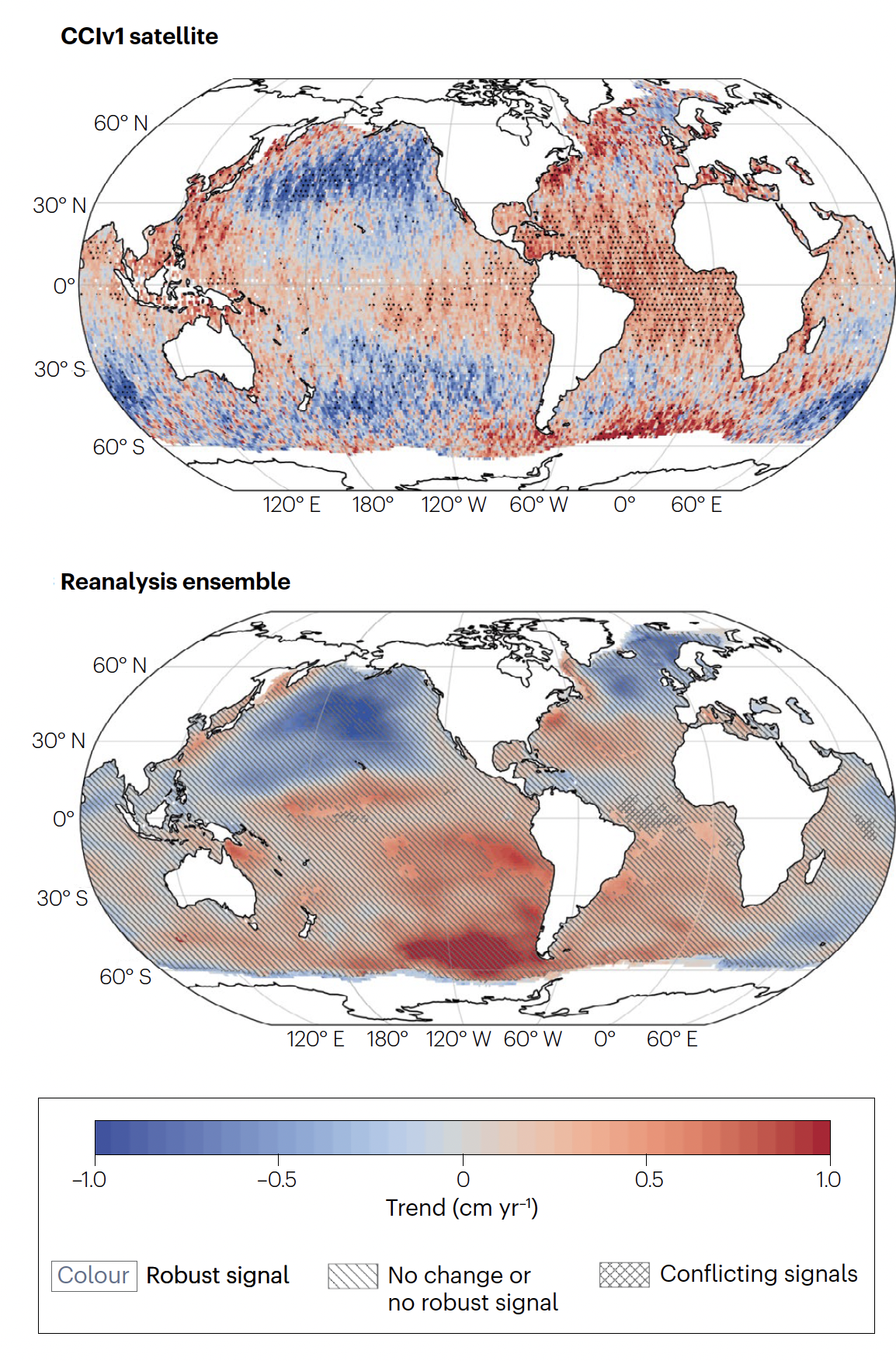
Reanalysis, hindcasts and observations
In coming to their conclusions, the study authors leant on reanalysis and hindcasts to derive trends for the main wave statistics – height, period and energy and direction.
While providing a good representation of historical wind wave climatology, these modelled datasets offer most value for trend analysis, signal detection and attribution when combined with observation-based measurements, such as those from satellites.
’Satellite sea state records provide a global view and an independent yardstick to validate or correct model trajectories so they more closely reflect the ‘real-world and evaluate their consistency,’ explains Guillaume Dodet of IFremer and a key member of the ESA Climate Change Initiative’s (CCI) Sea State project team. Dr Dodet, contributed to this latest review by analysing and interpreting the historical satellite data.
The CCI sea state project has generated, and continues to improve, the global sea state satellite record. Spanning 2002-2021, the latest version provides information on both 1Hz along-track and monthly significant wave height at 1°x1° spatial resolution using measurements from multiple satellite missions including Envisat, CryoSat-2, Jason-1, Jason-2, Jason-3, SARAL, Sentinel-3A. Additional data using Synthetic Aperture Radars from Sentinel-1 and ENVISAT provides useful information for determining swell direction and period, key determinant of sea state properties.
As with all other data products generated by research teams contributing to CCI, these sea state products are compiled using Global Climate Observing System definitions as reference to meet the requirements of climate users, including modellers.
The sea state data are globally consistent, fully uncertainty characterised and validated using in-situ measurements, all key requirements for assimilating observation data assimilated into models.
To access datasets for a suite of Essential Climate Variables including sea state visit climate.esa.int/data.
Reference
Casas-Prat, M., Hemer, M.A., Dodet, G. et al. Wind-wave climate changes and their impacts. Nat Rev Earth Environ 5, 23–42 (2024). https://doi.org/10.1038/s43017-023-00502-0