
17. April 2023
Satellite data aids understanding of ‘rivers in the sky’
Strong agreement between satellite-derived dataset and reanalysis products boosts research on atmospheric rivers
Climate change is pushing the water cycle out of balance and its impacts are being felt everywhere – from last year’s devastating floods in Pakistan that displaced nearly 8 million people, to the multi-year drought ongoing in the Horn of Africa leaving 20 million in urgent need of assistance.
Last month the UN Water Conference ended with commitments to scale-up action to tackle the water crisis. Meanwhile scientists have pointed to the need to use satellite data and Earth system models to improve our understanding of the flows and stocks of water around the world to better inform water policy and governance. This has shone a spotlight on the importance of transboundary flows of water in the atmosphere carried by ‘rivers in the sky’.
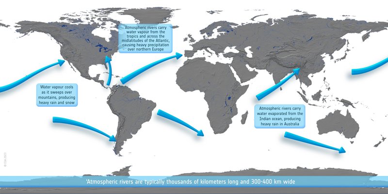
Atmospheric rivers
An atmospheric river can carry as much water as the Amazon river, flowing about 2 km above the Earth’s surface. Together with nocturnal low-level jets, atmospheric rivers are responsible for most of the water transport in the atmosphere. A series of atmospheric rivers has caused extreme snowfall in California this season, according to Nature.
To support research into better understanding these atmospheric flows, a project supported by the ESA Climate Change Initiative (CCI) has produced global maps of atmospheric water vapour over land and ocean from multiple satellite missions, creating high resolution daily products spanning 1985-2019.
A study supports confidence in the CCI water vapour data for studying these transport features.
“We need to study atmospheric rivers to better understand their characteristics – timing, how much water they carry, how much precipitation they will cause – for improving weather forecasting, flood forecasts, and water resource management, so it is great to see that the data can capture these characteristics, ” says Michaela Hegglin, who is the scientific lead of CCI Water Vapour and a study co-author, based at the University of Reading in the UK.
Atmospheric rivers carry water vapour poleward from the subtropics: at any one time there is one flowing somewhere on the planet. Typically hundreds of kilometers wide and thousands of kilometers long, they have been linked to intense rainfall events, and will play an increasingly important role in the water cycle as the atmosphere becomes hotter and wetter under climate change.
Nocturnal low-level jets are characterized by peaks in wind speed at a lower altitude in the atmosphere – in the first 500m above the surface – that tend to occur as steady seasonal features associated with weather fronts.
Linking observations and reanalysis
The study led by Jorge Eiras-Barca of the University of Vigo, Spain, compared the satellite-based ESA CCI Water Vapour product (CDR-2 v2) to records generated by the reanalysis models of the European Centre for Medium-Range Weather Forecasts (ECMWF). The researchers investigated how well these records agreed on the occurrence and water carrying capacity of atmospheric rivers and nocturnal low-level jets in different regions of the world.
Reanalysis models assimilate millions of observations – including from satellites – to better characterise the underlying and interacting physical processes in a global climate model. This enables the reanalysis to get closer to what happened to weather and climate in the real world. Reanalysis data is commonly used to initiate other models – such as models that can predict the future evolution of atmospheric rivers to inform water resource managers and emergency planners.
The team generated a database of nearly 40,000 atmospheric river and nocturnal low-level jet events across the world, comparing their occurrences and the atmospheric water content in the satellite data compared to ECMWF’s reanalysis products ERA5 and ERA-Interim.
They found strong agreement between the different datasets, with high correlations, in particular for ERA5 in the most important source and sink regions of water vapour and at mid latitudes.
“The CCI Water Vapour dataset is a new product, so having this strong agreement gives us confidence that not only ERA5 is doing a good job but that the satellite-derived dataset is useful at providing information on these events as well,” says Hegglin.
There was less agreement between the different data records in the main tropical forest regions, where the reanalysis models have too much moisture transport. “It would be interesting to see whether state-of-the-art climate models from CMIP* also show this, as it would help gain further insight into moisture recycling over these regions” says Hegglin.
Observational data are a crucial tool to judge which models are best at simulating climate, to benchmark which are more likely to accurately predict future changes and inform decision making.
ESA’s CCI programme is supporting the addition of CCI datasets into the ESMValTool, a tool that helps scientists compare models with observations, particularly for seasonal and geographical behaviours. ESMValTool now includes the new CCI Water Vapour datasets.
*CMIP is the Coupled Model Intercomparison Project. ESA is supporting this effort by hosting the CMIP international project office.
Reference:
Eiras-Barca, J., Algarra, I., Nieto, R., Schröder, M., Hegglin, M.I. & Gimeno, L.(2022) Analysis of the main source regions of moisture transport events with the new ESA CCI/CM-SAF total column water vapour climate data record (v2). Quarterly Journal of the Royal Meteorological Society, 148( 748) 3244– 3258. Available from: https://doi.org/10.1002/qj.4358