Introduction
The ESA river discharge Climate Change Initiative project is a precursor study. It aims to derive long term climate data records (at least over 20-years) of river discharge for some selected river basins (and some locations in the river network) using satellite remote sensing observations (altimetry and multispectral images) and ancillary data. It aims to provide a proof-of-concept for the feasibility for a potential River Discharge ECV product to meet the requirements for the Global Climate Observing System.
Objectives
This project covers precursor activities towards the production of data products that address the GCOS-defined requirements for the River Discharge ECV.
River discharge is defined as “the volume of water flowing through a river (or channel) cross section per unit of time” in the WMO international glossary of hydrology and is usually provided at a measuring point or gauging station in the river network. Discharge data could be used both at short-term time scale (e.g., for water management and flood protection) and at longer-term time scale (e.g., to monitor the flow of freshwater from rivers into the oceans and how this reduces ocean salinity and possibly changes the thermohaline circulation).
If “only” 0.0002% of water on earth is stored in the river network (Gleick, 1996), it corresponds to the main water exchange from land to the ocean with 36,000 km3/y (Milliman and Farnsworth, 2013). In addition, climate change (CC) is affecting the whole water cycle (Trenberth, 2011) and therefore river discharge. So, long-time series of river discharge are needed to better assess its impact on continents and for adaptation of human societies.
In the last few decades, satellite data has increasingly been used to complement in situ observation networks, whose availability is very heterogeneous and scarce in some regions. Yet, there is currently no satellite instrument measuring river discharge. Satellite measurements whose observations are linked with river discharge can be used indirectly to estimate it. Satellite radar nadir altimeters observes water surface elevation (not to be confused with water depth) along the satellite ground track, with multiple missions launched since the 90’s. Despite they do not all have the same orbit tracks, with different sensors characteristics, this wealth of data should allow long-term observations of water level variations for rivers. Besides, multispectral sensors, specifically in the near infrared (NIR) band, are also able to detect the variability of the dynamic of the river. The ratio between the reflectance of a dry pixel and a wet pixel is expected to represent the river flow variation. The large advantage of the multispectral sensors is the subdaily temporal resolution. However, because of the optical nature of the sensors, they cannot penetrate clouds and therefore they are less reliable during floods events.
Many studies have investigated the possibility to derive discharge using these satellite data or/and combining them with in situ or modelled discharge. However, no long time series over multidecadal time-period combining multiple sensors exist over different continents.
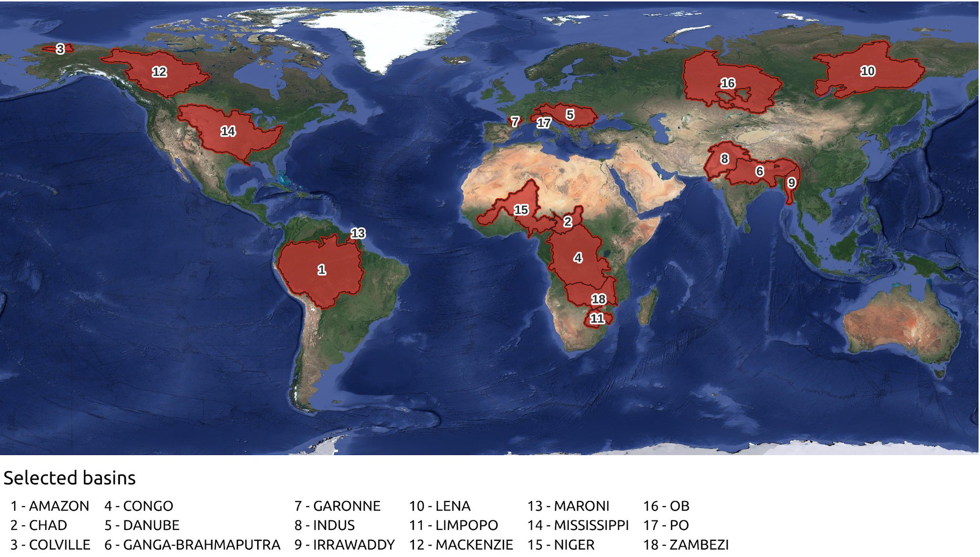
Over 15 river basins, the River Discharge CCI project will derive long term (at least 20 years) river discharge time series, using remote sensing observations and ancillary data, as a proof-of-concept of the feasibility of a CCI River Discharge ECV product.
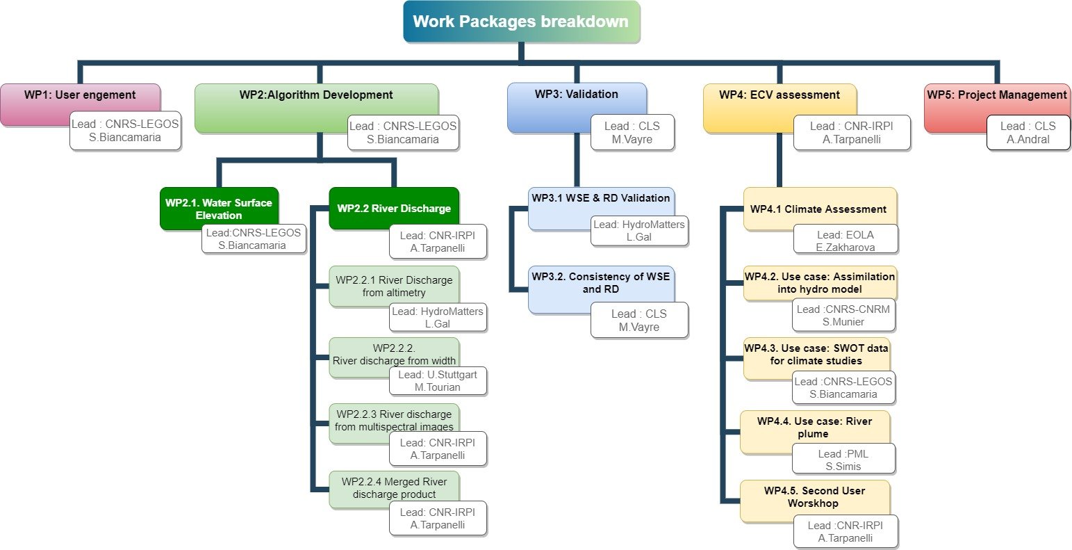
Project structure
The project is divided into 4 main tasks / work packages:
- WP1 is dedicated to user engagement with the update of the User requirement document (URD) after the Living Planet Symposium (LPS) in June 2025 (URD version 2.0) and the user workshop in 2026
- WP2 on algorithm development is divided into 2 sub-WP: one on water surface estimation from altimetry and the second on river discharge estimation with 4 different techniques: from altimetry, river width, multispectral images and a merged product
- WP3 is divided into 2 sub-WPs: WP 3.1 considers the validation of each model individually, and WP 3.2 deals with the consistency of the different methods of producing river discharge time series and therefore will consist in a round robin of the different methods and models.
- WP 4 is about ECV assessment with first the climate assessment, then 3 use cases on assimilation of the WP2 data into large scale hydrological models, on the analysis of the SWOT data for climate studies and on river plume and finally WP4.5 consists in organizing the second user workshop.