
Summary
For decades, scientists have monitored the location and thickness of sea ice, however sea ice age and drift reveal how long it endures through the seasons and how it travels across the polar oceans. Both quantities form the Sea Ice Essential Climate Variable specified by the Global Observing Climate System. This ESA Climate Change Initiative project will utilise decades of satellite data, advanced tracking techniques, and machine learning to create the first global climate data records of sea ice age and drift, supporting climate research from the Arctic to Antarctica.
Background
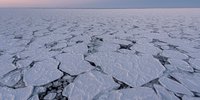
Sea ice is one of the most sensitive indicators of climate change. While satellite observations have enabled monitoring of sea-ice concentration, extent, and thickness for decades, the age of sea ice provides more than a snapshot of the ice cover: it tells us how long the ice has survived through melting seasons and export processes.
Sea-ice age provides valuable insights into the stability, vulnerability, and long-term memory of the polar ice cover. Older, multiyear ice is typically thicker, more stable, and more resistant to melting, while younger, first-year ice is thinner and more susceptible to climate variability. Over the past few decades, the Arctic has seen a marked loss of multiyear ice. In contrast, Antarctic sea ice is less well monitored, and its changes remain poorly understood.
Despite its scientific value, sea-ice age was only formally recognised as an ECV product by GCOS in 2022. Currently, the only widely used sea-ice age dataset, produced by NSIDC, covers the Arctic Ocean only. The Antarctic remains largely unmapped in terms of detailed sea-ice age.
Furthermore, long-term records of sea-ice drift, which are essential for age estimation and understanding dynamic processes, are incomplete before the early 1990s. This leaves much of the early satellite era unexplored. The absence of consistent, global records limits our ability to assess past and future changes in the polar regions and to evaluate the performance of climate models.
Sea-ice age and type have traditionally been estimated using two main approaches based on satellite observations: Lagrangian tracking and direct classification.

In Lagrangian tracking, individual ice parcels are followed over time by analysing satellite-derived sea-ice motion vectors. If an ice parcel survives from one year to the next, its age is incremented. This method uses drift and concentration data, often derived from passive microwave sensors, to trace where ice moves and how long it persists. It captures the dynamic evolution of the ice pack and provides a physically meaningful estimate of age but is sensitive to errors in inputs, and limited by data gaps.
The second approach is direct classification, which interprets satellite signals, such as brightness temperature or backscatter, to distinguish broader categories of ice types, such as first-year ice or multiyear ice, based on distinct physical properties. This is done using thresholds or statistical classifiers applied to passive microwave or scatterometer data. While faster and more direct, classification methods are challenged by ambiguous conditions, such as melt onset, refreezing, or thin snow-covered ice that can mask signal differences.
Aims and Objectives
This project will produce the first consistent, long-term Climate Data Records (CDRs) for sea-ice age and sea-ice drift. These will be global in coverage and span the satellite era from the late 1970s to the present. To achieve this, the project will:
- Develop a hybrid sea-ice-age algorithm that combines Lagrangian tracking (following the ice) with ice classification from direct interpretation of satellite data.
- Back-extend the global sea-ice drift climate data record before 1991.
- Use multi-sensor satellite data from passive microwave radiometry and scatterometer, including ESA’s heritage missions.
- Explore machine learning techniques to improve classification under challenging conditions like melt and refreeze transitions and regions of vast areas of pancake ice.
- Validate products using in situ data, buoys, SAR, and other EO records.
- Provide uncertainty estimates and traceable documentation.
- Demonstrate usage in scientific case studies.
These data records will support a wide range of applications, from understanding Arctic multiyear ice loss to detecting shifts in Antarctic sea-ice regimes and benchmarking the performance of climate models (CMIP7/SIMIP).
Project plans
The project runs from 2025 to 2028 and is structured into five core work packages:
- WP100 – User Needs & Requirements: Define what the community needs from the sea-ice age and drift records.
- WP200 – Algorithm R&D: Develop the core methods for retrieving ice age and type from EO data.
- WP300 – Processing System: Build the open-source system that will produce and distribute the products.
- WP400 – Validation: Quantify product quality and uncertainties, and provide independent evaluation.
- WP500 – Scientific Exploitation: Use the products in climate research, including studies of MYI budgets, sea-ice trends, and model evaluation.
A mid-project user workshop will bring together the modeling and cryosphere communities to review results and guide refinement. Final products will be documented and released for public and scientific use via the CCI Open Data Portal.
Access and search ESA Climate Change Initiative data products via our dedicate Open Data Portal
The SAGE will produce the following datasets:
- Sea-ice age CDR: Daily resolution, global coverage (Arctic + Antarctic), ~25 km grid, spanning from 1978 to near present.
- Sea-ice type product: Improved classification of FYI, MYI, and transitional types (e.g. young ice, pancake ice).
- Sea-ice drift CDR: Historical extension of existing drift records (prior to 1991), resulting in a full-length CDR, global coverage, and ~75 km grid.
Data will be delivered in CF-compliant netCDF format, include full uncertainty quantification, and be accompanied by open documentation and software. These data will be accessible via the ESA CCI open Data Portal.
The partners are:
Norwegian Meteorological Institute (MET Norway)
Project Role: Prime contractor and scientific lead, responsible for the overall management of the project.
MET Norway is also the leader of WP 300 (System Development and ECV Data Processing), which will build the open-source system that will produce and distribute the products.
S&T Norway AS (S&T)
Project Role: Leader of Work Package 600 (Project Management & Science Lead), providing project management and supporting the science leader in organising activities and coordinating with the consortium, project reporting and document control.
Nansen Environmental and Remote Sensing Center (NERSC)
Project Role: Leader of Work Package 200 (Algorithm Development), coordinating the development of the core methods for retrieving ice age and type from EO data.
University of Bremen (UB)
Project Role: Contributing to the development of algorithms, leading Work Packages 210 (Algorithm intercomparison and selection) and 250 (Blending of SITY and SIAG).
Université catholique de Louvain (UCLouvain)
Project Role: Leader of Work Package 100 (Requirements Analysis), which will define what the community needs from the sea-ice age and drift records.
University of Hamburg (UH)
Project Role: Leader of Work Package 400 (Validation). The goal of the work package is to quantify the product quality and uncertainties, and provide an independent evaluation.
University of Manitoba (UM)
Project Role: Leader of Work Package 500 (Product Assessment) and the Climate User Research Group. The work package will use the products in climate research, including studies of MYI budgets, sea-ice trends, and model evaluation.
Science Leader: Signe Aaboe - Norwegian Meteorological Institute
Project manager: Daniele Fantin - S&T
Technical Officer: Sarah Connors - European Space Agency

- Anton Korosov, Léo Edel, Heather Regan, Thomas Lavergne, Signe Aaboe, and Emily Jane Down. A Climate Data Record of Sea Ice Age Using Lagrangian Advection of a Triangular Mesh. Earth System Science Data Discussions. 2026. https://doi.org/10.5194/essd-18-721-2026
- R. Davy, H. Regan, A. Korosov, J. Dörr, P. Griewank, E. Olason. A Fair Assessment of Sea Ice Age Reduces Bias and Gives New Insight to Arctic Sea Ice Dynamics. Geophysical Research Letters. 2025. https://doi.org/10.1029/2025GL117765
On 19 September 2025, the SAGE project organised the full-day online event “Beyond Sea Ice Area: Exploring Alternative Diagnostics for Assessing Polar Climate Change”. The “daybinar” format (09:00-20:00 CEST) was designed to cover all time zones and enabled strong participation from the global cryosphere community. More than 180 participants had registered beforehand, confirming a wide interest from both modelling and observational communities.
The programme combined presentations from SAGE members, ESA, and leading international experts, with topics ranging from sea-ice thickness and fast-ice monitoring to new methods for computing sea-ice age. Antarctic perspectives were also included. The event’s objectives were to review the current state of Essential Climate Variable (ECV) sea-ice products, refine scientific and technical requirements for a new sea-ice age product, and discuss the robustness and relevance of polar climate data in an era of rapid change.
The program of the daybinar was:
- Signe Aaboe (Meteorologisk Institutt, Norway): Overview of the SAGE project
- Sarah Connors (ESA): Overview of the ESA-CCI activities and ECVs under development
- Alex Fraser (AAPP, Tasmania): Large-scale characterisation of sea ice from satellite remote sensing: a focus on fast ice and the marginal ice zone
- Dirk Notz (U. Hamburg, Germany): The one-, two- and three-dimensional nature of global sea ice change
- Jack Landy (UiT, Norway): Recent advances in remotely-sensed sea ice thickness from CryoSat-2, ICESat-2 and SWOT
- Anton Korosov: Computation of sea ice age using Lagrangian advection of a triangular mesh: observational and modelling perspectives
- Richard Davy (NERSC): Making sea ice age comparable across models and observations
- Walt Meier (NSIDC): Sea ice age products at NSIDC: lessons learned.
- Ted Maksym (WHOI, USA): Observing Antarctic sea ice processes with ICESat-2
Interactive discussions and live surveys provided valuable feedback on user needs and requirements. These outcomes will directly feed into the User Requirement Document (URD). The event demonstrated that the sea-ice age product under development in SAGE is timely and relevant, and that there is strong interest in complementary diagnostics beyond sea-ice area and extent. The full-day, multi-time-zone format was well received and may serve as a model for future community engagement. During the daytime blocks( in CEST time), attendance varied from 60 to 80 participants. In the afternoon and evening blocks, which correspond to morning or early afternoon in the Americas, attendance ranged from 20 to 45 participants.
Contact or questions: François Massonnet (francois.massonnet@uclouvain.be)