
Summary
Extreme heat events are emerging as one of the most pressing risks to human health, infrastructure, and urban ecosystems. However, current modelling approaches are yet to provide sufficiently detailed urban insights that can inform city authorities’ adaptation strategies or target investment.
This project aims enable more accurate evaluation of climate risks and adaptation options by integrate coarse-scale global and region models and earth observation data. Using novel validated downscaling methods the project will transform coarse-resolution Land Surface Temperature (LST) observations and combine them the high-resolving urban climate model, PALM-4U, to assess urban heat across diverse case study cities.
Through validated high-resolution LST datasets, robust uncertainty analyses, and a scientific roadmap, the project aims to support evidence to both support assessment of city-scale urban heat risks and contribute to international scientific efforts such as the forthcoming IPCC Special Report on Cities.
Project Background
Urban areas are among the most vulnerable environments to the impacts of climate change, with extreme heat events emerging as one of the most pressing risks to human health, infrastructure, and urban ecosystems. These risks are further amplified by the Urban Heat Island effect, where dense building structures, sealed surfaces, and limited vegetation cause heat to accumulate and intensify local temperature extremes. Prolonged exposure to such conditions can increase energy demand, strain health systems, and reduce overall liveability in cities.
Although the problem is widely recognised, current modelling approaches do not yet provide the detail that city authorities require for robust planning. Conventional global and regional climate models operate at scales that are too coarse to resolve the complexities of urban microclimates, while Earth Observation datasets, although extensive and well-validated, are often limited to kilometre-scale resolution. This gap between available information and local needs prevents decision-makers from obtaining reliable evidence to guide targeted adaptation strategies and investments.
The EO4UrbanClimate project was initiated to address this challenge. It forms part of ESA’s Climate Space Initiative, which promotes the integration of EO climate datasets into urban climate modelling frameworks. The project focuses on exploiting satellite-based Land Surface Temperature datasets from ESA’s CCI and combining them with advanced urban climate modelling. By applying innovative downscaling methods and integrating refined LST into the PALM-4U model, EO4UrbanClimate aims to produce city-scale climate information that is both scientifically robust and practically useful.
Through these activities, the project seeks to improve the understanding of urban temperature extremes, develop tested methodologies for risk assessment, and demonstrate their application across diverse case study cities. In doing so, EO4UrbanClimate aims to contribute to strengthening the scientific foundation needed for effective climate resilience planning in urban environments, while ensuring that results are openly accessible for researchers, policymakers, and practitioners
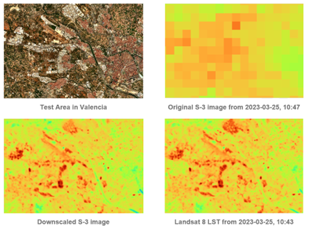
This project applies and validates innovative downscaling methods to transform coarse-resolution Land Surface Temperature (LST) data into data suitable for detailed city applications. These refined datasets will be combined with PALM-4U to assess urban heat across diverse case study cities, with the aim to enable more accurate evaluation of climate risks and adaptation options. The anticipated outcomes include validated high-resolution LST datasets, robust uncertainty analyses, and a scientific roadmap, contributing to international scientific efforts such as the forthcoming IPCC Special Report on Cities.
Project aims and objectives
The overall aim of EO4UrbanClimate is to explore how satellite-based datasets, in particular LST from ESA’s CCI Dataset, can enhance high-resolution urban climate modelling, specifically. While the project pays particular attention to urban heat, its scope is broader: it seeks to demonstrate how EO data can strengthen the representation of urban processes in models and improve the reliability of information available for climate-related assessments at city scale.
A primary objective is to apply methods for downscaling EO LST datasets so that they can be applied directly within the PALM-4U model. Current satellite products often provide valuable but coarse information, typically at km-scale resolution, which does not capture the fine-scale variation that matters within cities. EO4UrbanClimate addresses this by creating and validating higher-resolution datasets, with a focus on ensuring that they are consistent, accurate, and usable in urban modelling workflows. By doing so, the project aims to advance the integration of EO data into city-focused climate analysis and to provide a stronger empirical basis for scientific and applied work.
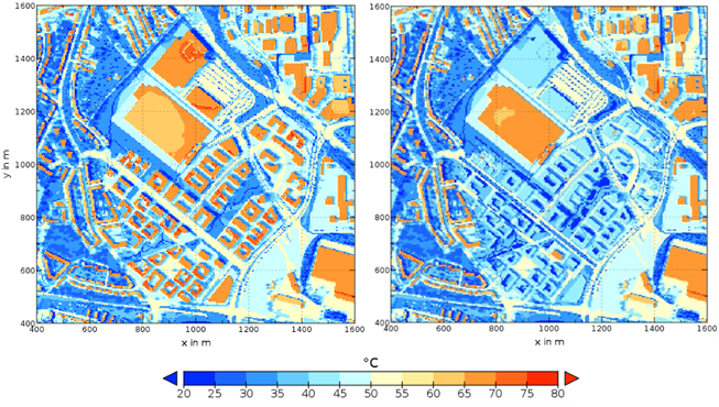
Another objective is to examine how these enhanced datasets can support the evaluation of measures designed to reduce climate risks in cities. This includes testing the ability of EO-based indicators to reflect the effects of adaptation strategies such as vegetation, reflective surfaces, or other interventions that influence surface energy balance. This objective aims to help demonstrate the practical value of EO integration beyond purely scientific advances.
A further objective is to test and demonstrate the methods across a range of urban and climatic settings. The project therefore applies its approach in case study cities in Europe, Africa, and Oceania, including Essen, Konstanz, Bergen, Šiauliai, Thessaloniki, Johannesburg, and Auckland. This diversity ensures that the methods are evaluated under different environmental and urban conditions, which is essential for demonstrating their transferability.
Finally, EO4UrbanClimate aims to contribute to broader international scientific efforts. The project’s results, including datasets, advanced modelling workflows, uncertainty assessments, and a scientific roadmap, will provide knowledge that can feed into assessments such as the forthcoming IPCC Special Report on Climate Change and Cities (2027). In this way, the project ensures that its findings support the wider scientific community in addressing urban climate challenges.
Project plan
The work will commence with a comprehensive review of the state of the art and a systematic analysis of existing knowledge gaps, which together will define the scientific requirements of the study. In parallel, a dataset inventory will be produced, providing a structured overview of all relevant Earth Observation datasets, climate models, and supporting infrastructure needed for the project. Building on this foundation, methodologies will be developed for integrating satellite-based datasets into the PALM-4U urban climate model. These methods will be tested for feasibility and the datasets will be adapted to meet the specific requirements of urban climate applications.
The core scientific activities will focus on applying the enhanced datasets and methodologies to assess climate risks in cities, with particular emphasis on urban heat exposure and the evaluation of possible adaptation measures. The studies will be validated through comparisons with in-situ observations and through reference to previous adaptation experiences in the selected case study cities. A systematic approach to uncertainty characterization will be undertaken alongside these analyses to strengthen the robustness and transparency of the results. The findings will then be consolidated into a scientific roadmap and made available, together with the created datasets, through open-access platforms. In this way, the results will be accessible not only to researchers, but also to policymakers and practitioners working on urban climate resilience.
OHB Digital Services (OHB DS), as the prime contractor, will be responsible for overall coordination, monitoring progress across all activities, and reporting to ESA. The scientific work will be led by GERICS, which brings long-standing expertise in urban climate modelling and co-development of services with city stakeholders. The project will also include regular workshops, consultations, and progress reviews, which will provide a forum for feedback and help ensure that the outputs are aligned with the practical needs of cities.
The project is planned for 18 months and is organized around two key milestones: a mid-term review and a final review. These checkpoints provide clear opportunities to assess progress, ensure that deliverables are on schedule, and confirm that both the scientific investigations and the practical objectives are being achieved.
Project Plan
- Initial Phase
- Comprehensive review of the state of the art and systematic analysis of knowledge gaps
- Definition of scientific requirements for the study
- Dataset inventory providing a structured overview of relevant Earth Observation datasets, climate models, and supporting infrastructure
- Comprehensive review of the state of the art and systematic analysis of knowledge gaps
- Method Development
- Development of methodologies for integrating satellite-based datasets into the PALM-4U urban climate model
- Feasibility testing and adaptation of datasets to meet the needs of urban climate applications
- Development of methodologies for integrating satellite-based datasets into the PALM-4U urban climate model
- Core Scientific Activities
- Application of enhanced datasets and methods to assess climate risks in cities
- Particular emphasis on urban heat exposure and evaluation of adaptation measures
- Validation through comparison with in-situ observations and reference to past adaptation experiences in case study cities
- Systematic uncertainty characterisation to improve robustness and transparency
- Application of enhanced datasets and methods to assess climate risks in cities
- Outputs and Dissemination
- Consolidation of findings into a scientific roadmap
- Publication of datasets and results via open-access platforms
- Ensuring accessibility for researchers, policymakers, and practitioners engaged in urban climate resilience
- Consolidation of findings into a scientific roadmap