
Under ESA's Climate Change Initiative, international science teams are undertaking research to generate 27 Essential Climate Variables (ECVs). These are key indicators that describe Earth's changing climate and are defined by the Global Climate Observing System. The 27 ECVs produced by the Climate Change Initiative (CCI) teams are ECVs that can be primarily generated from satellite data. They are validated against independent datasets, they have high levels of traceability and consistency, and include quantitative estimates of uncertainty.
Remote sensing process
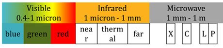
Satellite sensors detect radiation reflected or emitted by the Earth: from its atmosphere, land, ocean, and ice surfaces. Sensors that passively collect radiation emitted or reflected by the Earth - usually the origin of the radiation is the sun - are referred to as passive sensors. Detectors are engineered to measure radiation in specific frequency bands.
For example, carbon dioxide (CO2) is a greenhouse gas that absorbs solar radiation in specific bands. The measured absorbance within these frequency bands can be used to determine the concentration of CO2 in the atmosphere. The impact of other atmospheric constituents (such as water vapour, clouds, aerosols, ozone) are taken into account in algorithms developed by CCI scientists to produce global maps of carbon dioxide and monitor its levels since 2003.
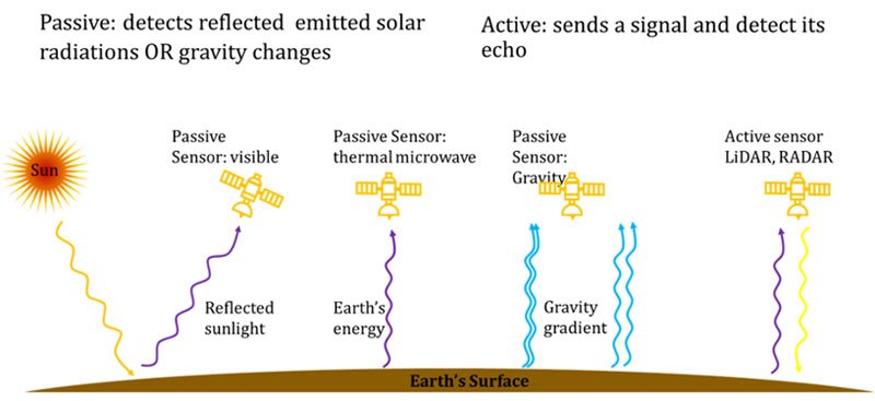
Sensors that have their own source of illumination are referred to as active sensors. They transmit pulses of radiation and measure the backscatter reflected off the Earth and back to the sensor.
For example, one type of altimeter sends an electromagnetic signal (in the microwave) to the sea surface and records the time elapsed before detecting the reflected echo. Knowing both the speed of light and the time taken, the distance above the sea surface to the antenna of the sensor. With additional information on the satellite’s orbit and geoid of the earth, CCI scientists can compute the sea level with millimetre precision and produce a 25-year global record of its variation.
Climate-quality data
The CCI ECVs are climate-quality data records, which refers to their suitability for climate research. Climate research involves studying subtle climate-related signals that occur over decades and are embedded in a noisy background of short-term variations driven by weather and other Earth system processes. This background signal can have a dynamic range of up to ten thousand times larger than an underlying climate trend.
Datasets that are climate-quality, called Climate Data Records (CDRs), must therefore have sufficient length and stability for climate applications, and include information to help users decide whether the data are suitable for their intended use.
To aid users, international coordination bodies have developed six quality indicators for satellite CDRs (Nightingale, J. et al., 2018). Data files should include ‘metadata’ information about the basic attributes of the data and its sensor source, documentation should transparently describe how it is produced, how well the dataset fits with agreed requirements for climate applications (for example the Global Climate Observing System requirements for ECVs), and how well the data compares to independent datasets, the data should indicate at a pixel level how reliable the measurements are via ‘quality flags’, and traceable uncertainty estimates should be provided.
What do we mean by error and uncertainty?
Uncertainty describes the doubt we have about a measured value. It enables users to determine the significance of their results, and is important for any applications of CDRs, from climate modelling, to climate research to climate services and decision making. Uncertainty should be characterised on a pixel-by-pixel basis, and is a crucial component of a CDR. But uncertainty is often confused with the term ‘error’.
The error in a measurement refers to the difference between the value that is measured, and the ‘true value’ in nature. Various effects contribute to the wrongness of a measurement, but it is impossible to know the measurement error (otherwise we would correct for it). Instead, we have to estimate the uncertainty of a measurement, which is determined by the spread of measured values (Merchant, C. et al., 2017).
For satellite-based CDRs, uncertainties arise at each step of the production process: due to sensor imperfections; the effects of the atmosphere absorbing and scattering the signal which cannot be perfectly ‘corrected’ for; during retrieval - when the geophysical variables are calculated - and during gridding and interpolation - when the data are produced to level 3 and level 4 versions. Uncertainty that arises early in the process needs to be taken into consideration in subsequent stages of processing.
Calibration and Validation
ESA scientists carry-out regular accuracy assessments of satellite data products. The derived ECVs are compared with independent field measurements and model simulations results. These comparisons have two purposes: (i) to adjust the data values to remove systematic biases, if any, and (ii) to estimate the quality of the derived ECVs (this is called validation), which is required by both climate science and modelling communities. Validation addresses the question: how good is this dataset? It involves comparing pixel-level values with reliable in-situ field measurements from around the world. There are now advanced statistical methods for estimating accuracy and dealing with scaling errors. As a data producer, ESA is undertaking major efforts to help standardise the validation process, working closely with GCOS and the Committee on Earth Observation Satellites (CEOS) to establish good practice protocols.
Calibration is the process of quantitatively defining a sensor’s response to known and controlled signal inputs. In passive techniques for satellite Earth observation, calibration is carried out on the satellite platform itself. For example, during the process of measuring surface temperature, infrared radiation emanating from a scene on the Earth’s surface arrives at a sensor, filters through the sensor optics and is detected as a voltage signal that is converted to counts. The scene counts are calibrated against reference targets of known temperature, called black bodies, which emit radiation with a specific spectrum with a temperature-dependent peak wavelength. Therefore, the calibration enables scene counts can be converted into a brightness temperature measurement.
Calibration and validation are important parts of the production of high-quality, reliable datasets.
All CCI's ECV datasets are fully validated and have high levels of traceability and consistency, including quantitative estimates of uncertainty required by both climate science and modelling communities.