
How we use and change the planet’s land surface accounts for around 10% of total human-related greenhouse gas emissions. Being able to accurately estimate and model future land carbon dynamics is important for tracking both international and national progress towards delivering on carbon reduction commitments geared to limiting global warming - as set out in the Paris Agreement - and also to evaluate existing and future land-based mitigation policy and action.
To support the climate modelling community, researchers working as part of ESA’s Climate Change Initiative have released a new data product that enables simulations to better represent vegetation processes and therefore estimate impacts of land use and land use change with greater confidence.
Globally-consistent maps of annual plant functional type
The new product, which also the subject of a new publication in ESSD [https://doi.org/10.5194/essd-2022-296], provides globally-consistent maps of annual plant functional type (PFT) – a proxy for parameters used to drive climate models and accounts for climate-relevant influence vegetation plays on the water, carbon and energy cycles, such as surface roughness, albedo and heat characteristics only.
Remote sensing provides detailed land cover information at a global scale – across 22 primary classes of the UN Land Cover Classification System. However, although useful for studying contemporary land use and land use change EO data do not allow for direct mapping of surface parameters associated to PFTs. Instead, the conventional approach is to ‘translate’ this global land cover information prior to its incorporation in models. This extra step introduces and propagates errors, resulting in significant uncertainty in the outputs of models and reduces confidence in their relative accuracy and ability to predict future change.
To overcome this problem, the dataset developers, led by Kandice Harper of the Université Catholique de Louvain, fused the globally-consistent medium-resolution land cover time series, developed via the European Space Agency’s Climate Change Initiative, with auxiliary high-resolution information of different surface types to create more spatially detailed PFT maps.
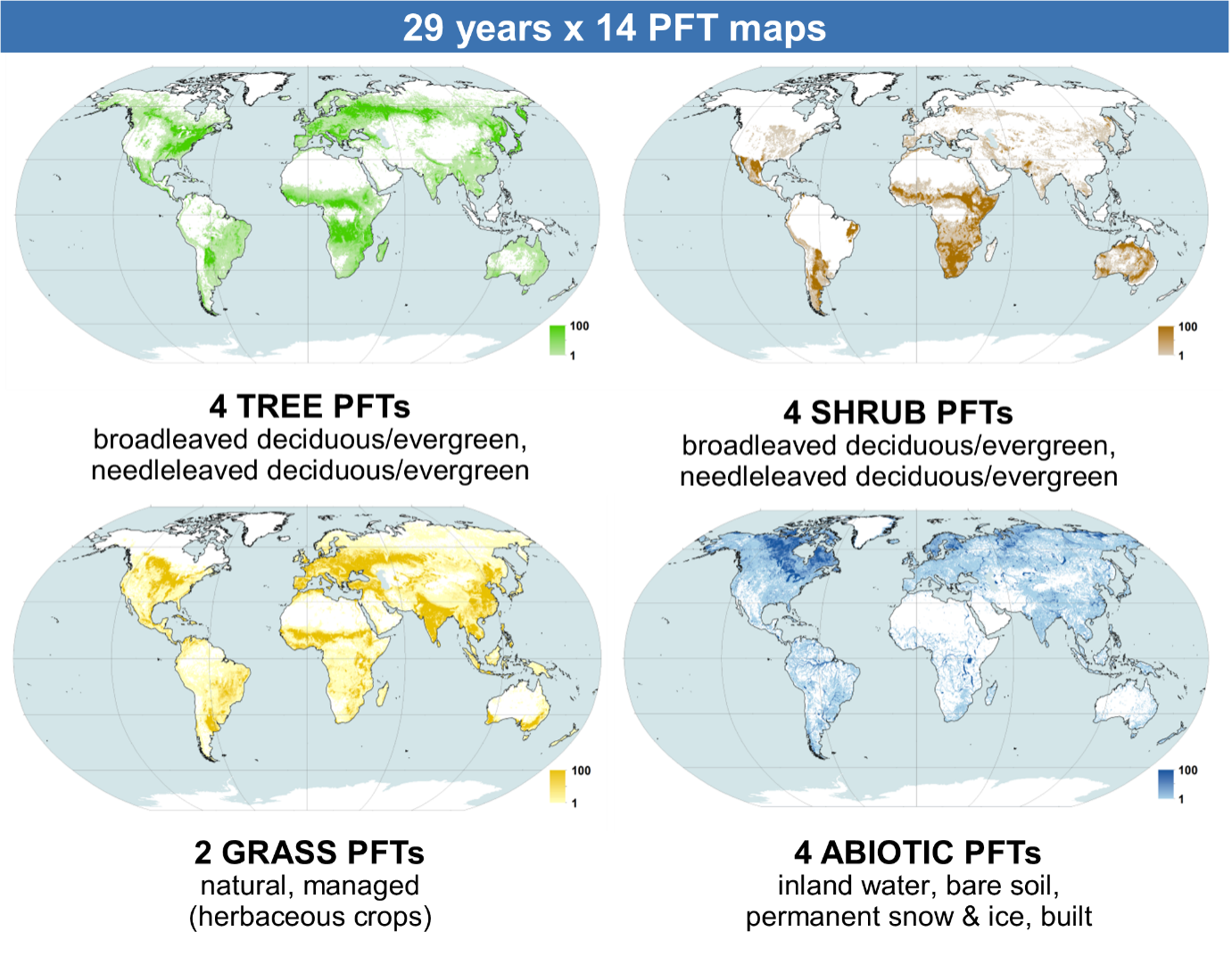
The resulting product has an annual resolution, covering 1992–2020 and indicates the specific percentage cover of 14 PFTs for each pixel at 300 m resolution. The full set of PFTs includes bare soil, built, water, snow and ice, natural grasses, managed grasses (i.e., herbaceous cropland), broadleaved deciduous trees, broadleaved evergreen trees, needleleaved deciduous trees, needleleaved evergreen trees, broadleaved deciduous shrubs, broadleaved evergreen shrubs, needleleaved deciduous shrubs, and needleleaved evergreen shrubs.
The traditional approach to land surface parameterisation in the models was to translate land cover classes into PFT proportions using globally uniform decision rules for each land cover category. For example, the same rules were applied to radically different agricultural landscapes, such as intensive/commercial agriculture and subsistence agriculture. This oversimplification led to unrealistic surface representations and large uncertainties. Providing the intra-class spatial variability of PFT across the world has allowed us to better represent the complexity of our Earth's surface and contribute to reducing uncertainties in climate models.
This study opens up new possibilities to gain a more realistic understanding of surface dynamics in climate models, and is a significant advance in the use of a high-resolution global representation of the Earth's surface, such as Sentinel-2.
Demonstrating Benefits over conventional maps
To demonstrate their benefit over the conventional map, the study authors used the new PFT product in two land surface models, ORCHIDEE and JULES. They found regional changes in the fractions of trees, short vegetation, and bare soil cover induce changes in surface properties, such as the albedo, leading to significant changes in surface turbulent fluxes, temperature, and vegetation carbon stocks.
A user tool is available for this product to cater for the needs of different climate models which often run at coarser spatial resolution, over specific areas and/or in projections other than Plate Carrée. It is freely available at maps.elie.ucl.ac.be/CCI/viewer/.
Reference:
Harper, K. L., Lamarche, C., Hartley, A., Peylin, P., Ottlé, C., Bastrikov, V., San Martín, R., Bohnenstengel, S. I., Kirches, G., Boettcher, M., Shevchuk, R., Brockmann, C., and Defourny, P.: A 29-year time series of annual 300 m resolution plant-functional-type maps for climate models, Earth Syst. Sci. Data, 15, 1465–1499, https://doi.org/10.5194/essd-15-1465-2023, 2023.
Data:
https://climate.esa.int/en/odp/#/project/land-cover
User tool: