
Dec. 8, 2022
Space-enabled ‘virtual stations’ bring radar sea-level observations closer than ever to the coast
Satellite measurements of sea level can help fill the gaps along large portions of the world's coastlines
Climate-induced sea-level rise brings serious threats to coastal communities, worsening the flood damage caused by high tides, low atmospheric pressure and cyclones, waves and storm surges. Space-based observations with radar altimeters have revealed that global mean sea level has risen by more than 3 mm per year over the past three decades and is accelerating. But although the observations from the Jason series of satellite missions have become a gold-standard height measure for the global oceans, sea-level measurements within 20 km of the coast were not reliable due to land contamination of the radar echo.
The team from ESA CCI’s Sea Level Project have now produced a long-term data set that complements and extends the measurements by coastal tide gauges, by improving the retrievals from satellite altimetry as close as possible to the coast at 756 virtual stations. These data fill, for the first time, a spatial data gap along large portions of the world’s coastlines and provide considerably refined information for climate applications. The data were published earlier this year and will be presented, with updates, next week (17 December) at the American Geophysical Union Fall Meeting.
Measuring sea level at the coast is what matters for the nearly 1 billion people dwelling in the coastal zone and low-lying territories, and the large number of coastal megacities all over the world.
Dr Jérôme Benveniste, the ESA technical officer for the Sea Level Project, says, “Getting closer to the coast is a challenge for radar altimetry and this has been largely overcome with the development of specific coastal processing algorithms by the Sea Level Project. While the footprint of the altimeter may be up to 10 km wide, we now can extract precise measurements up to 1 or 2 km from the coast.”
Figure 1 illustrates the distribution of 271 of the virtual stations (those within 3.5 km of the coast) compared with current tide gauges with consistently gap-free, monthly sea level data available over the 2002-2019 time span.
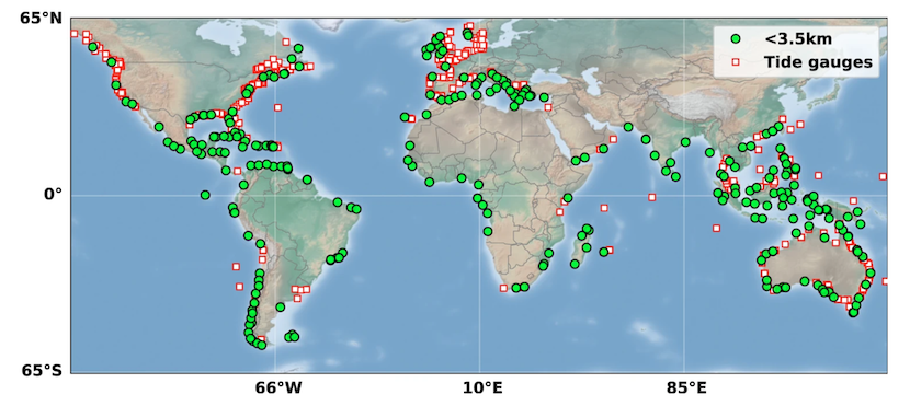
Figure 1. Green circles represent virtual stations (within 3.5 km of the coast); Red/white squares correspond to tide gauges having monthly data from Jan 2002-Dec 2019 with less than 24 months missing (credit: Cazenave et al., 2022).
The dataset has enabled investigations of how the trends in sea level at the coast differ from regional open-ocean trends. The image in figure 2 shows a sub-set of the network of virtual stations in black circles (for visibility only displaying those stations located less than 3.5 km from the coast), with a background map showing the sea level trends over an 18-year time span (from the routinely-produced Copernicus Climate Change Service dataset).
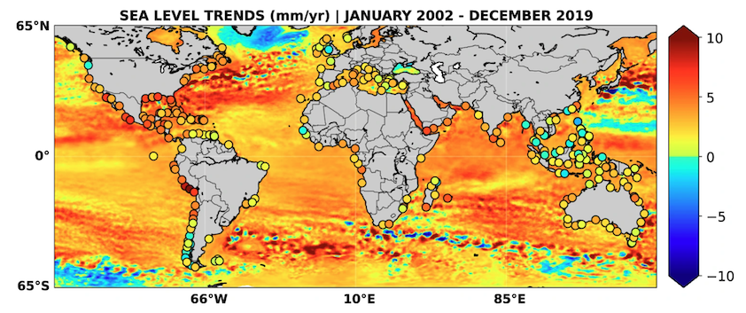
Figure 2. Coastal and regional sea-level trends (mm/yr) over the 18-year time span (credit: Cazenave et al., 2022).
It is clear that in some regions the trends differ from the regional background, particularly in southeast Asia where trends at the coast are lower than in the open ocean, and along the coast of Peru, where trends at the coast are higher. The processes that control coastal sea level change include the global mean and regional variability, as well as local-scale contributions from natural climate modes, changes in coastal currents and freshwater discharge by rivers as well as wind-generated waves. The study led by Anny Cazenave, based at LEGOS in Toulouse, France, found that 78% of the virtual stations had similar trends to the offshore trends in sea-level.
The coastal sea-level data will provide an important basis for investigating the processes affecting local sea-level – particularly in the 22% of locations where trends differ to the open ocean trends - to improve current understanding, as well as to improve climate models to better-simulate future sea-levels in vulnerable coastal regions.
The work has evolved since the paper was published, with even more refinements enabling higher precision. The improved results are published this week at the American Geophysical Union Fall Meeting (AGU-FM22) in a dedicated session.
The version 2.1 data set is freely available on the SEANOE respository as a monthly time series, with an along-track resolution of 300m. A new coastal sea level data set – sea level anomalies and trends, version v2.2 – will be published shortly after AGU-FM22 with the same DOI, https://doi.org/10.17882/74354 (Benveniste et al., Nature Scientific Data, published online 20 October 2020).
Dr Benveniste added, “Progress does not stop here with using only the gold-standard Jason satellites series: the relay has been taken over by Copernicus Sentinel-6, which carries a next generation Synthetic Aperture Radar (SAR) Altimeter. This sensor has been developed, tested and proven with the ESA Earth Explorer CryoSat and Copernicus Sentinel-3 satellites, and permits a very-high-resolution footprint starting at 300 m, but the measurement can be theoretically “synthetised” every half metre with the so-called ‘Fully-Focused SAR processing’, enabling us to get even closer to the coast with more precise measurements.
While the measurements from the new missions accumulate, we will also include data acquired with the Copernicus Sentinel-3 mission, which, due to its long repeat cycle offers a dense ground-track coverage and therefore we will monitor coastal regions never monitored before with SAR Altimetry.”
Reference:
Cazenave, A., Gouzenes, Y., Birol, F. et al. Sea level along the world’s coastlines can be measured by a network of virtual altimetry stations. Commun Earth Environ 3, 117 (2022). https://doi.org/10.1038/s43247-022-00448-z
Further reading:
Benveniste et al., Coastal sea level anomalies and associated trends from Jason satellite altimetry over 2002-2018, Nature Scientific Data, 2020;
Birol et al., The X-TRACK/ALES multi-mission processing system: New advances in altimetry towards the coast, Advances in Space Research, Volume 67, Issue 8, Pages 2398-2415, 2021, https://doi.org/10.1016/j.asr.2021.01.049
Dieng, H.B., Cazenave, A., Gouzenes, Y., Sow, B.A., Trends and inter-annual variability of coastal sea level in the Mediterranean Sea: : Comparison with tide gauges and models, Advances in Space Research, Volume 68, Issue 8, Pages 3279-3290, 2021, https://doi.org/10.1016/j.asr.2021.06.022
Gouzenes, Y., Léger, F., Cazenave, A., Birol, F., Bonnefond, P., Passaro, M., Nino, F., Almar, R., Laurain, O., Schwatke, C., Legeais, J.-F., and Benveniste, J.: Coastal sea level rise at Senetosa (Corsica) during the Jason altimetry missions, Ocean Sci., 16, 1165–1182, https://doi.org/10.5194/os-16-1165-2020, 2020.
International Altimetry team, Altimetry for the future: Building on 25 years of progress, Advances in Space Research, 2021, https://doi.org/10.1016/j.asr.2021.01.022