
Assimilating ESA CCI marine datasets for Reanalysis
Key results
- 1. Using ESA CCI SST, Sea level, Ocean Colour and Sea Ice improves reanalysis
- 2. ESA CCI SST, Sea level, Ocean Colour and Sea Ice datasets are consistent
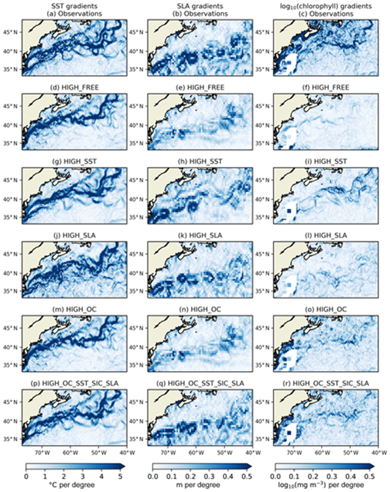
ESA CCI multi-year datasets of Ocean Colour, Sea Surface Temperature (SST), Sea Level and Sea Ice were used in reanalyses. The datasets were assimilated individually and together. They were consistent in representing spatial features such as fronts, sea ice extent, and bloom activity. Assimilating them together had a larger impact than assimilating individually, providing information about model biases and errors which will be used to improve future model versions.
Oceans cover 70% of the world’s surface, they are a source of oxygen and a sink for carbon, their circulation affects weather patterns and temperatures. To fully understand the behaviour of the oceans under changing climatic conditions we need to monitor recent changes. The European Space Agency (ESA) Climate Change Initiative (CCI) produces datasets of Essential Climate Variables (ECVs) for this purpose.
The marine ECVs used in this work were:
- Ocean Colour[1]
- Sea Surface Temperature (SST)[2]
- Sea Level[3]
- Sea Ice[4]
The aims of the study were the following:
- Assess mutual consistency of the four marine ECVs from a data assimilation perspective
- Assess consistency of physical–biogeochemical relationships in reanalyses assimilating different combinations of these ECVs
- Assess the impact of assimilating the ECVs on the marine carbon cycle
ESA CCI ECV products have been assimilated into a global physical–biogeochemical ocean model to create a set of 13-year reanalyses at 1° resolution and 3-year reanalyses at 1∕4° resolution. The variables were assimilated individually and in combination. The satellite products were found to be consistent in their representation of spatial features such as fronts, sea ice extent, and bloom activity (Figure 1). Phytoplankton biomass correlated more strongly with net air–sea heat fluxes in the reanalyses than chlorophyll concentration did, and the correlation was weakened by assimilating ocean colour data, suggesting that studies of phytoplankton bloom initiation based solely on chlorophyll data may not provide a full understanding of the underlying processes.
[1] https://climate.esa.int/en/projects/ocean-colour/
[2] https://climate.esa.int/en/projects/sea-surface-temperature/
[3] https://climate.esa.int/en/projects/sea-level/
[4] https://climate.esa.int/en/projects/sea-ice/
References
Ford, D. A. (2020), Assessing the role and consistency of satellite observation products in global physical-biogeochemical ocean reanalysis. https://os.copernicus.org/articles/16/875/2020/
About the author

This article was produced in 2022 by David Ford. David has worked on ocean modelling and data assimilation research at the Met Office since 2008. His main focus is on developing and validating the pre-operational global coupled physical-biogeochemical ocean modelling system. His work covers time scales from near-real-time forecasts to decadal reanalyses, with both operational and climate research applications. David has also worked on shelf seas biogeochemical modelling and validation, and developing error covariances for the data assimilation component of the Met Office’s operational physical ocean forecasting system.