The High Resolution (HR) Land Cover (LC) Essential Climate Variable (ECV) project involves the accurate description and analysis of land cover (LC) and land cover change (LCC) using Earth Observation (EO) data with high spatial resolution (10-30m), with the primary objective of examining the role of the spatial resolution of the detected changes to support climate modelling research. LC change is in fact both a cause and a consequence of climate change either when the change is human-induced or generated from natural events.
Land Cover has a key role on surface energy, water and carbon fluxes variables. Moreover, LCC has an impact on radiative (albedo), aerodynamic, evaporative properties, carbon storage with different effects on surface temperature and precipitation. These factors have been taken into account by the climate modelling community to properly model Earth climate at a global scale using medium resolution EO data (i.e., 100m).
However, improvement of sensor technology achieved during the last decade makes EO data with high spatial resolution available. For these reasons, HR_LandCover_CCI will produce LC and LCC maps with high spatial resolution and investigate their impact and the crucial role of spatial resolution on climate models at regional scale.
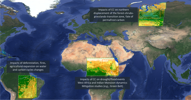
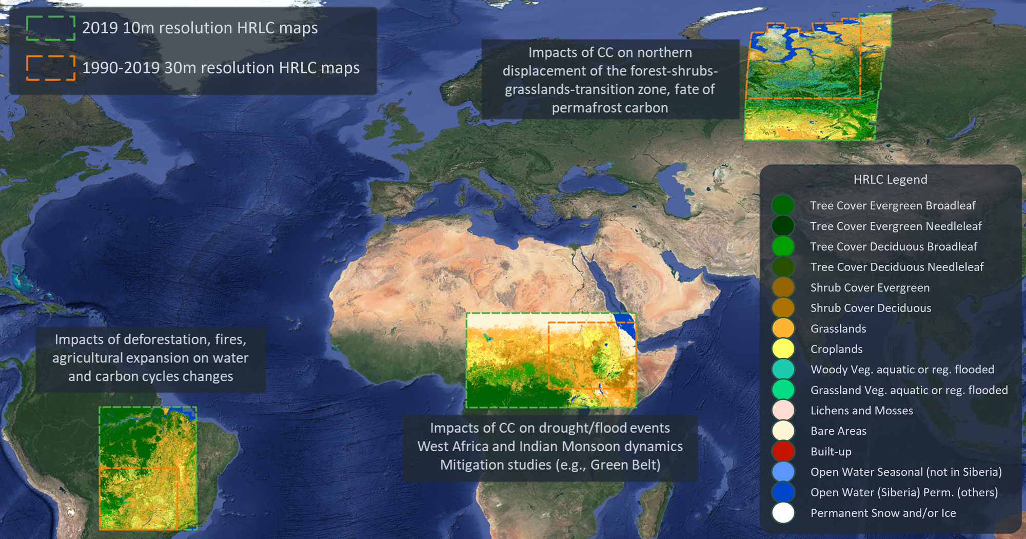
The project will focus primarily on three subcontinetal regions and sub-regions within them:
- South America (Amazon forest);
- West Africa (Sahel band);
- Western Siberia;
- New areas under evaluation.
Objective
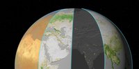
The primary objective of HR_LandCover_CCI is to study and investigate the role of the spatial resolution of LC and LCC in supporting climate modelling research at regional scale. HR_LandCover_CCI aims at improving the understanding of the interaction between climate and land cover while increasing the spatial resolution of 1 order of magnitude (from 300m to 10-30m) with respect to the LandCover_CCI.
About the project
Land cover (LC) is defined by FAO as the observed physical cover of the Earth surface. It includes the vegetation and human-made infrastructures, like water, ice, rock, forest or urban areas. Its assessment and the monitoring of its dynamics are of extreme importance for the correct estimation of Earth radiation budget. Moreover, LC is correlated to land use and by proxy allows the study of how human activities impact on the Climate.
CCI+ aims at the cooperation between climate modelers, EO communities and industrial partners on the development of software systems for the pre-operational ECV production in a research context.
During the three years of the programme, the Consortium will generate and validate LC maps and LCC using EO data acquired over the last decades and continuously acquired today. This will enable the study of LC and LCC and their impact on Earth Climate at regional scale using high spatial resolution EO data (i.e., 10-30m). Indeed, with the evolution of technology, a higher spatial resolution and an increased operational availability of EO satellite data make it possible to overcome several limitations of LC mapping. The HR_LandCover_CCI variable is crucial for improving our understanding in relation to climate modelling and mitigation/adaptation strategies.
The primary objectives are:
- Examining the role of the spatial resolution to support climate research;
- Studying LCC in key regions exposed to extreme climate conditions or characterized by significant climate changes over the last decades;
- Understanding classification variability across spatio-temporal scales.
The EO products:
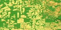
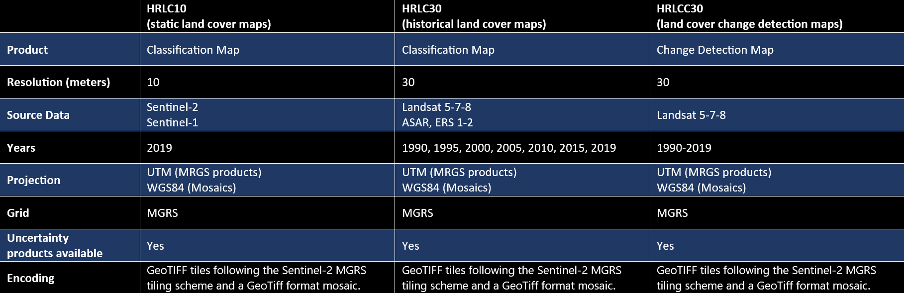
- HRLC10: High Resolution Land Cover Maps at 10m spatial resolution for year 2019 (also referred to as static maps) at subcontinental scale for 2019;
- HRLC30: High Resolution Land Cover Maps at 30m spatial resolution for years 1990, 1995, 2000, 2005, 2010, 2015, 2019 (also referred to as historical maps) in sub-regions of HRLC10;
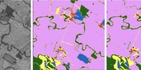
- HRLCC30: High Resolution Land Cover Change Maps at 30m spatial resolution of yearly changes. A map every 5 years (1990-1995, 1995-2000, 2000-2005, 2005-2010, 2010-2015,2015-2019) is provided which reports (high priority) changed pixels and their year.
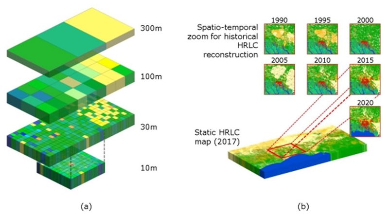
HR_LandCover_CCI will keep spatio-temporal consistency with respect to the CCI Medium Resolution (MR) Land Cover. Several new challenges should be addressed that concerns EO science, validation, engineering and climate modelling. In particular, challenges related to the Climate studies are:
- Improvement of the land cover description by refining the relationships between LC classes and Plant Functional Types especially for mixed species classes;
- Improvement of how LC and LCC influence the energy, water, carbon (CO2, CH4) budgets;
- Improvement of the understanding of surface-atmosphere interactions and climate change impacts on vegetation (e.g., in regions where climate warming already impacts vegetation, like greening in Arctic);
- Better evaluation of the LCC impacts on the climate to support climate mitigation/adaptation policies at regional and local levels.
Challenges and novelty related to EO Science consist of:
- The use of HR data available in the past/current archives at a larger temporal interval and stronger variability across the years with respect to MR data;
- The shift of the processing paradigm from the analysis of many MR images per year to the processing of (very) few images per year characterized by HR;
- The systematic use of multi-sensor data to fill the temporal gaps in data availability and to address cloud cover issues;
- The spatio-temporal consistency with CCI MRLC results.
High quality results will be guaranteed by several validation activities:
- Independent accuracy assessment based on the quantification of accuracy and on the disentanglement of the different uncertainties characterizing the HRLC deliverables;
- Intercomparison analysis in order to compare existing HRLC products and the ones delivered by the Consortium;
- The assessment of the impact of HR on climate models.
Coming next
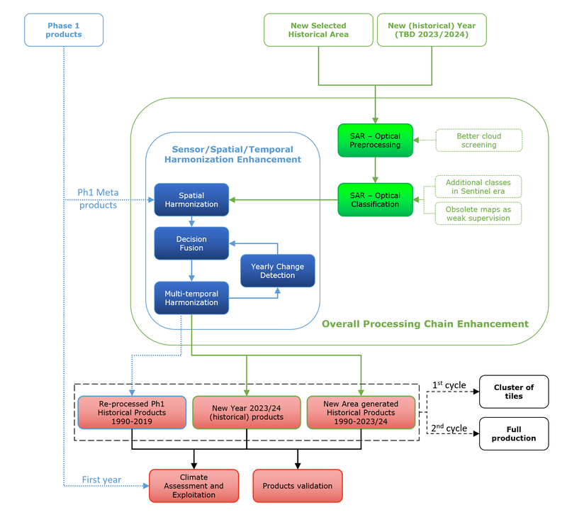
- Historical products re-processing: generation of an improved version of historical products by enhanced sensor decision fusion and spatial and temporal harmonization.
- Historical production on a new selected area.
- Historical (forward) production of year 2023 (or 2024) for all the considered areas: the forward production of the year 2023 (or 2024) will be performed in the Sentinel Era, characterized by a 10m spatial resolution and a high availability of satellite image data.
Access the full suite of ESA Climate Change Initiative data products via our dedicate Open Data Portal, including those generated by the High Resolution Land Cover project.
The following products generated by High Resolution Land Cover ECV project are available with subcontinental or regional spatial extent:
- HRLC10: High Resolution Land Cover Maps at 10m spatial resolution for year 2019 (sub-continental spatial extent, also referred to as static maps),
- HRLC30: High Resolution Land Cover Maps at 30m spatial resolution for years 1990, 1995, 2000, 2005, 2010, 2015, 2019 (regional spatial extent, also referred to as historical maps),
- HRLCC30: High Resolution Land Cover Change Maps at 30m spatial resolution of yearly changes. A map every 5 years (1990-1995, 1995-2000, 2000-2005, 2005-2010, 2010-2015,2015-2019) is provided which reports changed pixels and their year (high priority) within the 5-years temporal interval (regional spatial extent),
- Associated uncertainty products for each of the classification product lines HRLC10, HRLC30 and HRLCC30.
Products characteristics are as follows
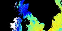
Products have been generated for three sub-continental areas within Africa, South-America and Siberia. Therefore they give a representation of very different ecosystems and climatic conditions.
DOWNLOAD:
This section provides access to the suite of data products.
CEDA Archive Project page
Sub-contnental/static land cover maps (HRLC10) CEDA Archive pages:
- Siberia (Northern Siberia region) at 10m spatial resolution for 2019
- Amazonia (Eastern Amazonas region) at 10m spatial resolution for 2019
- Africa (Eastern Sahel region) at 10m spatial resolution for 2019
Regional/historical land cover maps (HRLC30) and land cover change detection maps (HRLCC30) CEDA Archive pages:
Under the guidance of the University of Trento, an international team of experts in EO information extraction, validation and climate sciences is working together with industrial companies to deliver high quality HR LC ECV products.
The Consortium is composed by the following partners:
- Università degli studi di Trento (UNITN), Italy
- Fondazione Bruno Kessler (FBK), Italy
- Université Catholique de Louvain (UCL), Belgium
- Università degli studi di Pavia (UNIPV), Italy
- Università degli studi di Genova (UNIGE), Italy
- Politecnico di Milano (PoliMi), Italy
- Laboratoire des Sciences du Climat et de l'Environnement (LSCE), France
- Centro de Investigación Ecológica y Aplicaciones Forestales (CREAF), Spain
- University of Exeter (UNEXE), UK
- e-GEOS, Italy
- GeoVille, Austria
- Planetek Italia, Italy
The organisation of the work is based on four distinct teams with specific expertise:
- EO Science Team: Università degli studi di Trento (UNITN), Fondazione Bruno Kessler (FBK), Università degli studi di Pavia (UNIPV), and Università degli studi di Genova (UNIGE);
- Validation Team: Université Catholique de Louvain (UCL), Politecnico di Milano (PoliMi), University of Exeter (UNEXE);
- Climate Research Group: Laboratoire des Sciences du Climat et de l'Environnement (LSCE), Centre de Recerca Ecològica i Aplicacions Forestals (CREAF), University of Exeter (UNEXE);
- System Engineering: e-GEOS, Planetek Italia and GeoVille.
- G. Bratic, D. Oxoli, M.A. Brovelli. Map of Land Cover Agreement: Ensambling Existing Datasets for Large-Scale Training Data Provision. MDPI. 2023, Remote Sensing. 2023; 15(15):3774. https://doi.org/10.3390/rs15153774
- L. Bruzzone, and the CCI HRLC Team. ESA CCI High Resolution Land Cover: Methodology and EO Data Processing Chain. ESA. 2022.
- L. Bruzzone, and the CCI HRLC Team. ESA CCI High resolution Land Cover Products. ESA. 2022, ESA Living planet Symposium, May 2022, Bonn.
- R. San Martin, C. Ottlé, V. Bastrikov, Ph. Peylin, and the HRLC working group. ESA-CCI High Resolution Land Cover products: Contribution to the parameterization of ORCHIDEE land surface model and to the understanding of land-atmosphere interactions. ESA. 2022, ESA Living planet Symposium, May 2022, Bonn.
- L. Pesquer, C. Domingo-Marimon, J. M. Espelta, J. Pino. Spatio-temporal analysis of Ecosystem Functional Types in relation to land cover/use changes. 2022, IALE 2022 European Landscape Ecology Congress, 11-15 July 2022.
- L. Maggiolo, D. Solarna, G. Moser, S. B. Serpico. Optical-SAR decision fusion with Markov random fields for high-resolution large-scale land cover mapping. IEEE. 2022, IEEE Geoscience and Remote Sensing Symposium, Kuala Lumpur, Malaysia, July 17-22, 2022. https://doi.org/10.1109/IGARSS46834.2022.9884751
- D. Solarna, L. Maggiolo, G. Moser, S. B. Serpico. A tiling-based strategy for large-scale multisensor optical-SAR image registration. IEEE. 2022, IEEE Geoscience and Remote Sensing Symposium, Kuala Lumpur, Malaysia, July 17-22, 2022. https://doi.org/10.1109/IGARSS46834.2022.9884048
- L. Maggiolo, D. Solarna, G. Moser, S. B. Serpico. Registration of multisensor images through a conditional generative adversarial network and a correlation-type similarity measure. MDPI. 2022, Remote Sensing, 14(12):2811, 2022. https://doi.org/10.3390/rs14122811
- D. Marzi, S. Todmal and P. Gamba. Mapping globally using multitemporal Sentinel-1 SAR: a semiautomatic approach. IEEE. 2021, IEEE International India Geoscience and Remote Sensing Symposium, Virtual Meeting, 2021. https://doi.org/10.1109/InGARSS51564.2021.9792073
- A. Sorriso, D. Marzi, P. Gamba. A General Land Cover Classification Framework for Sentinel-1 SAR Data. IEEE. 2021, IEEE 6th International Forum on Research and Technology for Society and Industry (RTSI), Napoli, September 2021. https://doi.org/10.1109/RTSI50628.2021.9597319
- C. Lamarche, S. Bontemps, Q. Marissiaux, P. Defourny, O. Arino. Towards a Multi-Level Sampling Scheme for Land Cover and Land Cover Change Validation. Lessons Learned from the Land Cover Climate Change Initiative. IEEE. 2021, IEEE International Geoscience and Remote Sensing Symposium, Brussels, Belgium, Virtual Meeting, 12-16 July 2021. https://doi.org/10.1109/IGARSS47720.2021.9553898
- D. Marzi, P. Gamba. Wide-scale Water Bodies Mapping Using Multi-temporal Sentinel-1 SAR Data. IEEE. 2021, IEEE International Geoscience and Remote Sensing Symposium, Brussels, Belgium, Virtual Meeting, 12-16 July 2021. https://doi.org/10.1109/IGARSS47720.2021.9553072
- B. Pinel-Puysségur, L. Maggiolo, M. Roux, N. Gasnier, D. Solarna, G. Moser, S. B. Serpico, F. Tupin. Experimental comparison of registration methods for multisensor SAR-optical data. IEEE. 2021, IEEE International Geoscience and Remote Sensing Symposium, Brussels, Belgium, Virtual Meeting, 12-16 July 2021. https://doi.org/10.1109/IGARSS47720.2021.9553640
- I. Podsiadlo, C. Paris, L. Bruzzone. An Approach Based on Low Resolution Land-Cover-Maps and Domain Adaptation to Define Representative Training Sets at Large Scale. IEEE. 2021, IEEE International Geoscience and Remote Sensing Symposium, Brussels, Belgium, Virtual Meeting, 12-16 July 2021. https://doi.org/10.1109/IGARSS47720.2021.9553498
- C. Paris, L. Orlandi, L. Bruzzone. An Interactive Strategy for the Training Set Definition Based on Active Self-Paced Learning Implemented on a Cloud-Computing Platform. IEEE. 2021, IEEE Geoscience and Remote Sensing Letters, Vol. 17. https://doi.org/10.1109/LGRS.2021.3114611
- D. Marzi, P. Gamba. Inland Water Body Mapping Using Multi-temporal Sentinel-1 SAR Data. IEEE. 2021, IEEE Journal of Selected Topics in Applied Earth Observations and Remote Sensing, vol. 14, pp. 11789-11799, 2021. https://doi.org/10.1109/JSTARS.2021.3127748
- L. Maggiolo, D. Solarna, G. Moser and S. B. Serpico. Automatic area-based registration of optical and SAR images through generative adversarial networks and a correlation-type metric. IEEE. 2020, IEEE International Geoscience and Remote Sensing Symposium, Waikoloa, Hawaii, USA, 26 September - 2 October 2020. https://doi.org/10.1109/IGARSS39084.2020.9323235
- Y. T. Solano-Correa, K. Meshkini, F. Bovolo, L. Bruzzone. A land cover-driven approach for fitting satellite image time series in a change detection context. SPIE. 2020, SPIE Conference on Image and Signal Processing for Remote Sensing XXVI, Virtual Meeting, 21-25 September 2020. https://doi.org/10.1117/12.2573942
- I. Podsiadlo, C. Paris, L. Bruzzone. A study of the robustness of the long short-term memory classifier to cloudy time series of multispectral images. SPIE. 2020, SPIE Conference on Image and Signal Processing for Remote Sensing XXVI, Virtual Meeting, 21-25 September 2020. https://doi.org/10.1117/12.2574383
- L. Pesquer, C. Domingo-Marimon, J. Cristóbal, C. Ottlé, P. Peylin, F. Bovolo, L. Bruzzone. Comparison of ecosystem functional type patterns at different spatial resolutions in relation with FLUXNET data. SPIE. 2019, In Remote Sensing for Agriculture, Ecosystems, and Hydrology XXI, vol. 11149, p. 1114908. https://doi.org/10.1117/12.2533049
- L. Bruzzone, and the CCI HRLC Team. CCI Essential Climate Variables: High Resolution Land Cover. ESA. 2019, ESA Living Planet Symposium, Milan, Italy, 13-17 May 2019.
- G. Bratic, V. Yordanov, M. A. Brovelli. High-resolution land cover classification: cost-effective approach for extraction of reliable training data from existing land cover datasets. Taylor and Francis. 2023, International Journal of Digital Earth, 16:1, 3618-3636. https://doi.org/10.1080/17538947.2023.2253784
Your opinion can help us:
- Register to the mailing list to get updates on project news, click here;
- Share your views and requirements on the use of products by fulfilling the CCI+HRLC questionnaire. Click on or scan the QR code.

Key contacts for the High Resolution Land Cover project:
- Science Lead: Lorenzo Bruzzone
- Project Manager: Francesca Bovolo