
Little Picture - Global monthly temperature from 1940 to 2023
A little picture by Neil Kaye of the UK Met Office
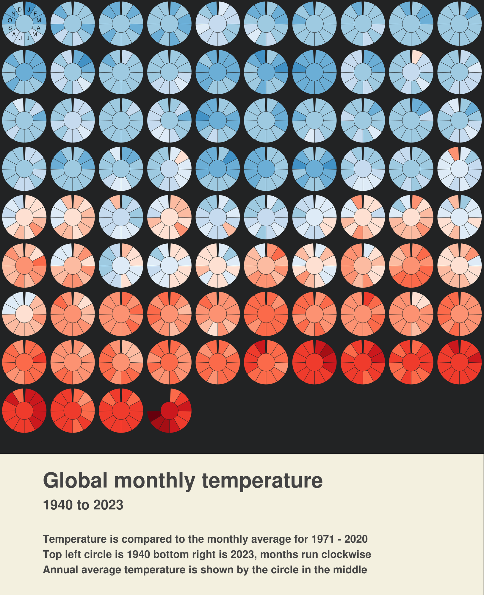
This Little Picture shows global monthly temperature between 1940 and 2023 compared to the average for 1971-2020. These are shown in the form of segmented circles that are coloured clockwise from January to December. The centre circle is the annual average. Surface air temperature provides a key indicator of climate change, contributing to the
“global surface temperature record”. A goal of limiting changes in global surface temperature provides the measure for the Paris climate agreement and is considered as one of 54 Essential Climate Variables by the Global Climate Observing System that are used to characterise the Earth system.
About
This Little Picture shows global monthly surface air temperature between 1940 and 2023 compared to the average for 1971-2020. These are shown in the form of segmented circles that are coloured clockwise from January to December. The centre circle is the annual average.
Surface air temperature provides a key indicator of climate change, contributing to the “global surface temperature record”. A goal of limiting changes in global surface temperature provides the measure for the Paris climate agreement and is considered as one of 54 Essential Climate Variables by the Global Climate Observing System that are used to characterise the Earth system.
Judges commendations
- Good use of colour to communicate lots of information.
Data
The Little Picture uses surface air temperature monthly means and monthly anomalies from ERA5 averaged over the global domain from ECMWF's Copernicus Climate Change Service ERA5 reanalysis. Neil used ERA5 monthly series anomaly global temperature data 1940-2023.
Licence
This Little Picture is published under CC BY-SA 4.0 licence.
The big picture
The European Space Agency (ESA), the European Centre for Medium-Range Weather Forecasts (ECMWF), and the European Organisation for the Exploitation of Meteorological Satellites (EUMETSAT) work closely together to measure, process & make space-derived information about the climate available.
ESA
The mission of the Climate Change Initiative (CCI) is to realise the full potential of the long-term global Earth Observation archives that the European Space Agency (ESA), together with its Member states, has established over the past 40 years, as a significant and timely contribution to the climate databases required by the United Nations Framework Convention on Climate Change. The ESA Climate Office provides a free & open CCI data facility bringing together ECV data from across its twenty-seven climate science projects, including a CCI Data Standards and a CCI Toolbox.
ECMWF
The Copernicus Climate Change Service (C3S) supports society by providing freely available authoritative information about the past, present and future climate in Europe and the rest of the World. C3S is one of the six thematic information services provided by the Copernicus Earth Observation Programme of the European Union, and has been entrusted by the European Commission to the European Centre for Medium-Range Weather Forecasts (ECMWF). One of the core components of C3S includes the Climate Data Store (CDS). This is a one-stop shop for climate information. It provides free and easy access to a wide range of climate datasets via a searchable catalogue. A freely available online toolbox allows users to build workflows and applications suited to their needs.
EUMETSAT
EUMETSAT operates missions both to provide weather and climate data for its member states, and as an entrusted entity under the Copernicus programme. Several missions are operated collaboratively with ESA, providing complimentary expertise and data processing, to process and distribute land, marine, and atmosphere relevant products for users. Data from EUMETSAT operated missions is frequently available in near-real-time, facilitating rapid monitoring and forecasting. Via EUMETCast, the EUMETSAT Data Services, or WEkEO, users can access data in ways that suit their needs. The data is used by the EUMETSAT satellite applications facilities, as well as across the various Copernicus Services.
next