
Little Picture - Global lake area represented as a drop of water
A Little Picture by Ted du Bois
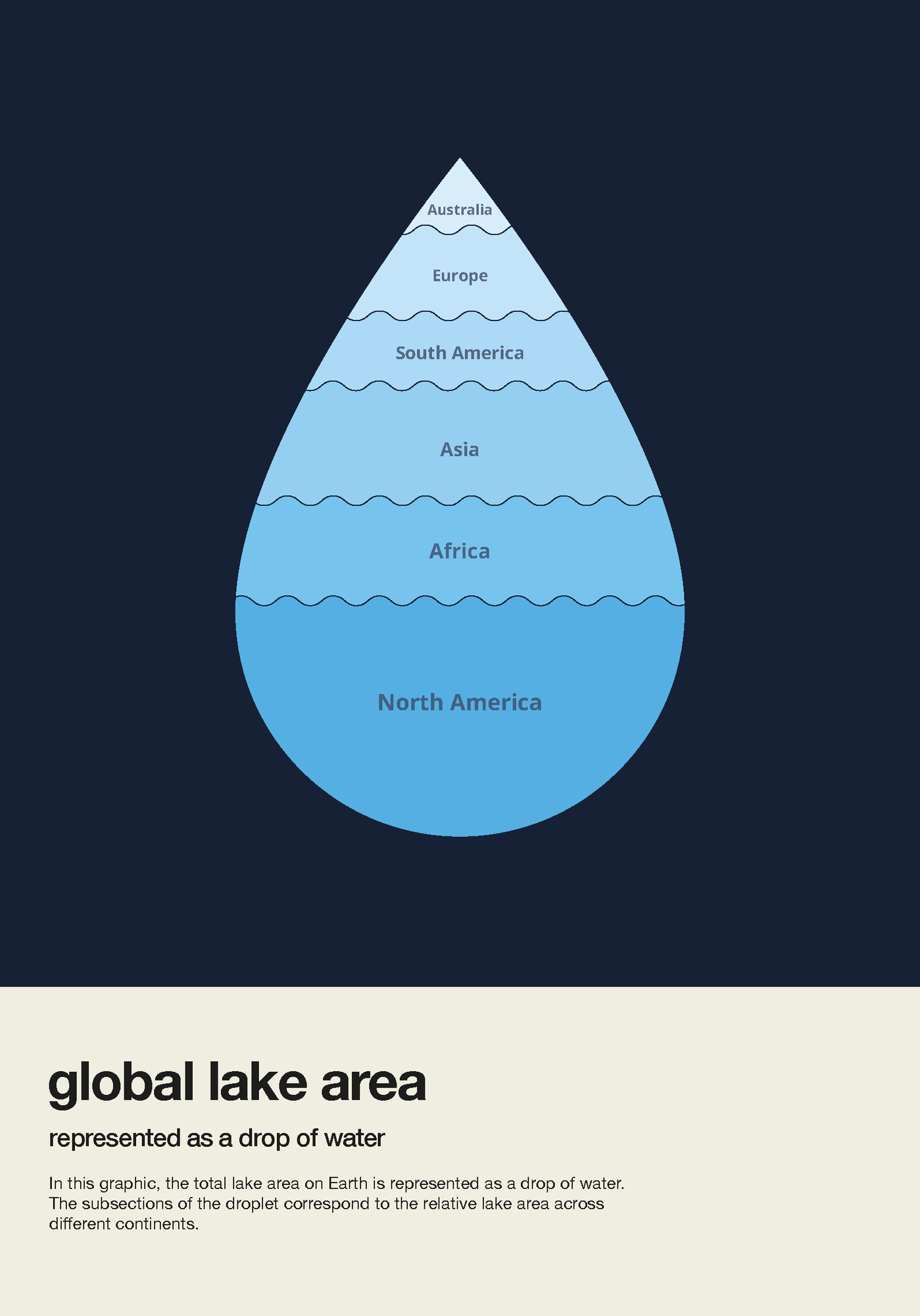
This Little Picture depicts global lake area represented as a drop of water for the world's continents.
In Ted's own words: 'Lakes provide a broad range of freshwater ecosystem services, such as water supply, biomass production, recreation, wildlife habitat and supporting and regulating ecosystem services.
At first glance lakes may appear robust and unyielding. Almost as if they are an everlasting feature of local landscapes. However, factors such as continued periods of drought (fuelled by climate change), industrial pollution and overuse can cause irreversible damage to lakes and consequently severely impact the ecosystem services lakes provide.
About
This Little Picture depicts global lake area represented as a drop of water.
Lakes play an important role in local and global climate regulation. Understanding their complex behaviour in a changing environment is essential to effective water resource management and mitigation of climate change effects. Lakes is considered as one of 54 Essential Climate Variables by the Global Climate Observing System. ESA' Climate Change Initiative Lakes project is harnesses in the satellite archive to generate global and consistent climate data records.
In Ted's own words:
'With this Little Picture I want to make a statement and raise awareness on the importance of lakes and their fragility in our current world. To do so, I presented global lake area as a stylised single drop of water. The area of the sections within the droplet corresponds to the relative lake area across different continents. This gives the viewer a better understanding on how lake area is distributed and how scarce lakes already are in some parts of the world.'
Judges commendation
- Simple. Clear. Novel illustration for a less publicly obvious Essential Climate Variable
Data
For this Little Picture Ted used a CSV file containing details of Lake area (km2), count and percentage of land coverage by continent - https://github.com/littlepictures/datasets/blob/main/lakes/cci_lakes_continents.csv. This data is drawn from the ESA Climate Change Initiative Lakes project. Carrea, L.; Crétaux, J.-F.; Liu, X.; Wu, Y.; Bergé-Nguyen, M.; Calmettes, B.; Duguay, C.; Jiang, D.; Merchant, C.J.; Mueller, D.; Selmes, N.; Simis, S.; Spyrakos, E.; Stelzer, K.; Warren, M.; Yesou, H.; Zhang, D. (2022): ESA Lakes Climate Change Initiative (Lakes_cci): Lake products, Version 2.0.2. NERC EDS Centre for Environmental Data Analysis, 06 July 2022. doi:10.5285/a07deacaffb8453e93d57ee214676304. https://dx.doi.org/10.5285/a07deacaffb8453e93d57ee214676304
Script
To create his Little Picture, Ted set out to create a custom take on the (Voronoi) Treemap. After experimenting with Python and Rawgraph he realised these tools were not going to give me the custom compartmented waterdrop design. He then shifted to Adobe illustrator and used the plugin GetShapeArea (https://gist.github.com/bryanbuchanan/11387501) to calculate subareas in a droplet shaped vector from the data.
Licence
This Little Picture is published under CC BY-SA 4.0 licence.
The big picture
The European Space Agency (ESA), the European Centre for Medium-Range Weather Forecasts (ECMWF), and the European Organisation for the Exploitation of Meteorological Satellites (EUMETSAT) work closely together to measure, process & make space-derived information about the climate available.
ESA
The mission of the Climate Change Initiative (CCI) is to realise the full potential of the long-term global Earth Observation archives that the European Space Agency (ESA), together with its Member states, has established over the past 40 years, as a significant and timely contribution to the climate databases required by the United Nations Framework Convention on Climate Change. The ESA Climate Office provides a free & open CCI data facility bringing together ECV data from across its twenty-seven climate science projects, including a CCI Data Standards and a CCI Toolbox.
ECMWF
The Copernicus Climate Change Service (C3S) supports society by providing freely available authoritative information about the past, present and future climate in Europe and the rest of the World. C3S is one of the six thematic information services provided by the Copernicus Earth Observation Programme of the European Union, and has been entrusted by the European Commission to the European Centre for Medium-Range Weather Forecasts (ECMWF). One of the core components of C3S includes the Climate Data Store (CDS). This is a one-stop shop for climate information. It provides free and easy access to a wide range of climate datasets via a searchable catalogue. A freely available online toolbox allows users to build workflows and applications suited to their needs.
EUMETSAT
EUMETSAT operates missions both to provide weather and climate data for its member states, and as an entrusted entity under the Copernicus programme. Several missions are operated collaboratively with ESA, providing complimentary expertise and data processing, to process and distribute land, marine, and atmosphere relevant products for users. Data from EUMETSAT operated missions is frequently available in near-real-time, facilitating rapid monitoring and forecasting. Via EUMETCast, the EUMETSAT Data Services, or WEkEO, users can access data in ways that suit their needs. The data is used by the EUMETSAT satellite applications facilities, as well as across the various Copernicus Services.
next