
Little Picture - Swiss glaciers reduction
A little picture by Cinzia Bongino
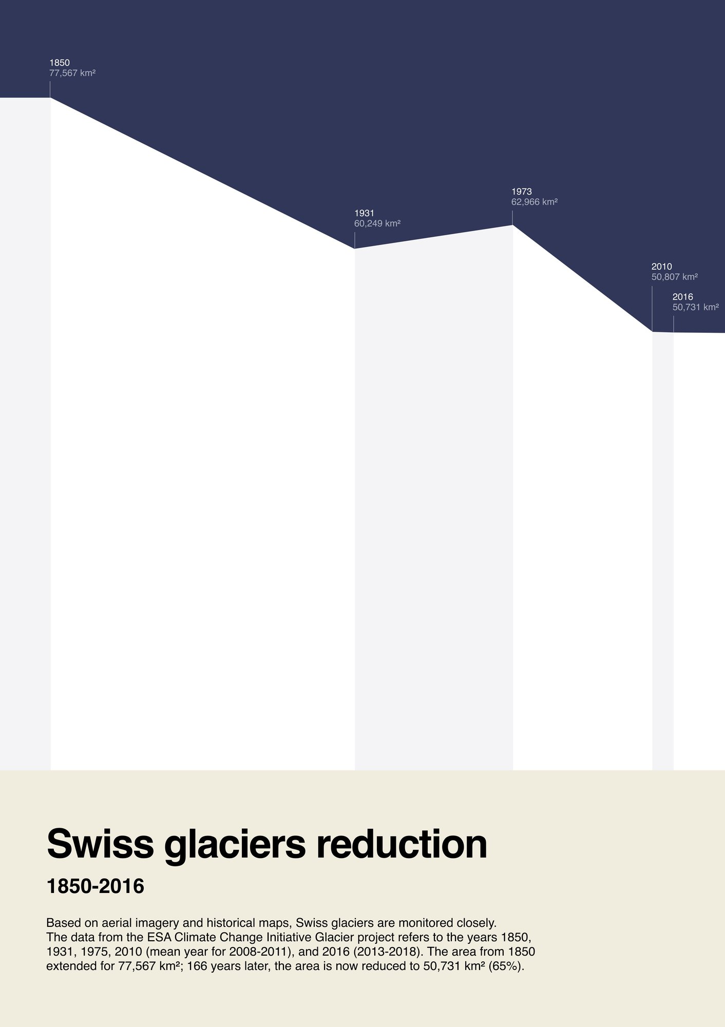
This Little Picture illustrates the reduction of a selected glaciers in south-west Switzerland (specifically, the area that spans the Theodul to the Mellichgletscher glaciers). The Area Chart is designed to resemble a mountain skyline, with the height shifting based on extension of the glacier.
About
This Little Picture illustrates the reduction of a selected glaciers in south-west Switzerland (specifically, the area that spans the Theodul to the Mellichgletscher glaciers). The Area Chart is designed to resemble a mountain skyline, with the height shifting based on extension of the glacier.
Judges commendation
- 'Very clear and effective'
Data
This Little Picture used data from https://github.com/littlepictures/datasets/tree/main/glaciers which is derived from the ESA Climate Change Initiative Glacier project, specifically - Arendt, A. et al (2016): ESA Glaciers Climate Change Initiative (Glaciers CCI): Randolph Glacier Inventory gridded data product, v5.0.https://catalogue.ceda.ac.uk/uuid/5daf1ff8dd2941a18bb4120ceea95721
Script
No scripts were used to generate this Little Picture. However, glacier area was calculated by opening the shapefile data from the years 1850, 1931, 1973, 2010, and 2016 with QGIS. By opening the attribute table it was possible to add columns and make calculations with the listed columns. Once ready, Cinzia exported the data in a csv format to Google Sheets. Here, with some basic formulas, she summed the area of each glacier and transformed from m2 to km2. Once she had all the totals per year and uploaded the data into RAWGraphs, where a line chart ws generated. The final visual has then been assembled on Figma.
Licence
This Little Picture is published under CC BY-SA 4.0 licence.
The big picture
The European Space Agency (ESA), the European Centre for Medium-Range Weather Forecasts (ECMWF), and the European Organisation for the Exploitation of Meteorological Satellites (EUMETSAT) work closely together to measure, process & make space-derived information about the climate available.
ESA
The mission of the Climate Change Initiative (CCI) is to realise the full potential of the long-term global Earth Observation archives that the European Space Agency (ESA), together with its Member states, has established over the past 40 years, as a significant and timely contribution to the climate databases required by the United Nations Framework Convention on Climate Change. The ESA Climate Office provides a free & open CCI data facility bringing together ECV data from across its twenty-seven climate science projects, including a CCI Data Standards and a CCI Toolbox.
ECMWF
The Copernicus Climate Change Service (C3S) supports society by providing freely available authoritative information about the past, present and future climate in Europe and the rest of the World. C3S is one of the six thematic information services provided by the Copernicus Earth Observation Programme of the European Union, and has been entrusted by the European Commission to the European Centre for Medium-Range Weather Forecasts (ECMWF). One of the core components of C3S includes the Climate Data Store (CDS). This is a one-stop shop for climate information. It provides free and easy access to a wide range of climate datasets via a searchable catalogue. A freely available online toolbox allows users to build workflows and applications suited to their needs.
EUMETSAT
EUMETSAT operates missions both to provide weather and climate data for its member states, and as an entrusted entity under the Copernicus programme. Several missions are operated collaboratively with ESA, providing complimentary expertise and data processing, to process and distribute land, marine, and atmosphere relevant products for users. Data from EUMETSAT operated missions is frequently available in near-real-time, facilitating rapid monitoring and forecasting. Via EUMETCast, the EUMETSAT Data Services, or WEkEO, users can access data in ways that suit their needs. The data is used by the EUMETSAT satellite applications facilities, as well as across the various Copernicus Services.