
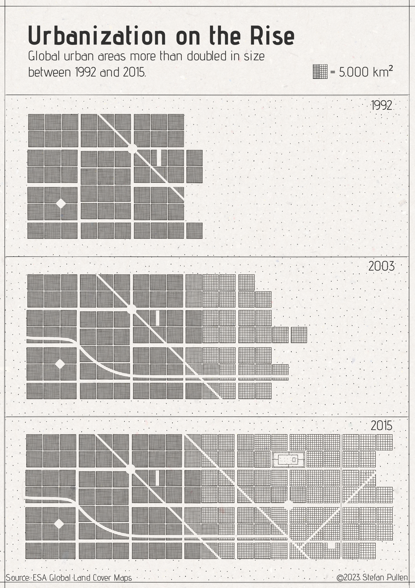
This data visualisation illustrates the astonishing growth of urban areas worldwide from 1992-2016. In just two decades, urban area has more than doubled, reshaping our global landscape. Stefan used ESA Climate Chang Initiative Land Cover datasets to determine the total growth of urban areas worldwide. This satellite data forms the backbone of the visualisation. Each square on the chart represents 5,000 km² of urban area. The cross-hatching density translates to years, which allows the audience to see the development with each iteration.
To enhance accessibility, I've chosen a monochrome palette, and I've incorporated elements reminiscent of maps, such as roads and parks.
In his own words:
'Urbanisation on the Rise' paints a picture of the relentless march of urbanisation, inviting viewers to contemplate the implications of this monumental shift.'
About
The Little Picture illustrates the astonishing growth of urban areas worldwide between 1992-2016. Land Cover is a key aspect of the climate system and is important for the understanding of climate and its vulnerability to changes on the surface of the Earth - it is considered as one of 54 Essential Climate Variables by the Global Climate Observing System.
Judges commendations
- 'Simple and stylish'
- 'Brings abstract data very close to the reader; simple and complex at the same time
Data
The Little Picture uses data Land Cover data from the ESA Climate Change Initiative (Defourny, P. (2019): ESA Land Cover Climate Change Initiative (Land_Cover_cci): Global Land Cover Maps, Version 2.0.7. Centre for Environmental Data Analysis, date of citation. https://catalogue.ceda.ac.uk/uuid/b382ebe6679d44b8b0e68ea4ef4b701c).
Specifically, a subset of this dataset made available for the competition was used for trees ESA Land Cover 1 (lc-1) (https://github.com/littlepictures/datasets/tree/main/lc-1)
Code
Stefan created a basic Python script (https://github.com/stefanpullen/combinecountries) to combine the data sets and create a new data set on global urbanization development. He then used these values to determine the number of squares needed for each year. The dataset contains land cover areas in km2 based on satellite images. He constructed the data visualisation using Figma.
Licence
This Little Picture is published under CC BY-SA 4.0 licence.
The big picture
The European Space Agency (ESA), the European Centre for Medium-Range Weather Forecasts (ECMWF), and the European Organisation for the Exploitation of Meteorological Satellites (EUMETSAT) work closely together to measure, process & make space-derived information about the climate available.
ESA
The mission of the Climate Change Initiative (CCI) is to realise the full potential of the long-term global Earth Observation archives that the European Space Agency (ESA), together with its Member states, has established over the past 40 years, as a significant and timely contribution to the climate databases required by the United Nations Framework Convention on Climate Change. The ESA Climate Office provides a free & open CCI data facility bringing together ECV data from across its twenty-seven climate science projects, including a CCI Data Standards and a CCI Toolbox.
ECMWF
The Copernicus Climate Change Service (C3S) supports society by providing freely available authoritative information about the past, present and future climate in Europe and the rest of the World. C3S is one of the six thematic information services provided by the Copernicus Earth Observation Programme of the European Union, and has been entrusted by the European Commission to the European Centre for Medium-Range Weather Forecasts (ECMWF). One of the core components of C3S includes the Climate Data Store (CDS). This is a one-stop shop for climate information. It provides free and easy access to a wide range of climate datasets via a searchable catalogue. A freely available online toolbox allows users to build workflows and applications suited to their needs.
EUMETSAT
EUMETSAT operates missions both to provide weather and climate data for its member states, and as an entrusted entity under the Copernicus programme. Several missions are operated collaboratively with ESA, providing complimentary expertise and data processing, to process and distribute land, marine, and atmosphere relevant products for users. Data from EUMETSAT operated missions is frequently available in near-real-time, facilitating rapid monitoring and forecasting. Via EUMETCast, the EUMETSAT Data Services, or WEkEO, users can access data in ways that suit their needs. The data is used by the EUMETSAT satellite applications facilities, as well as across the various Copernicus Services.
next