
Feb. 8, 2024
Satellites reveal fire drivers in global deforestation hotspot
New study reveals land cover changes are driving tree losses in the South American Chaco
Using satellite records, scientists have unpicked the environmental drivers of wildfires in one of the world’s deforestation hotspots - with land cover identified as a key factor.
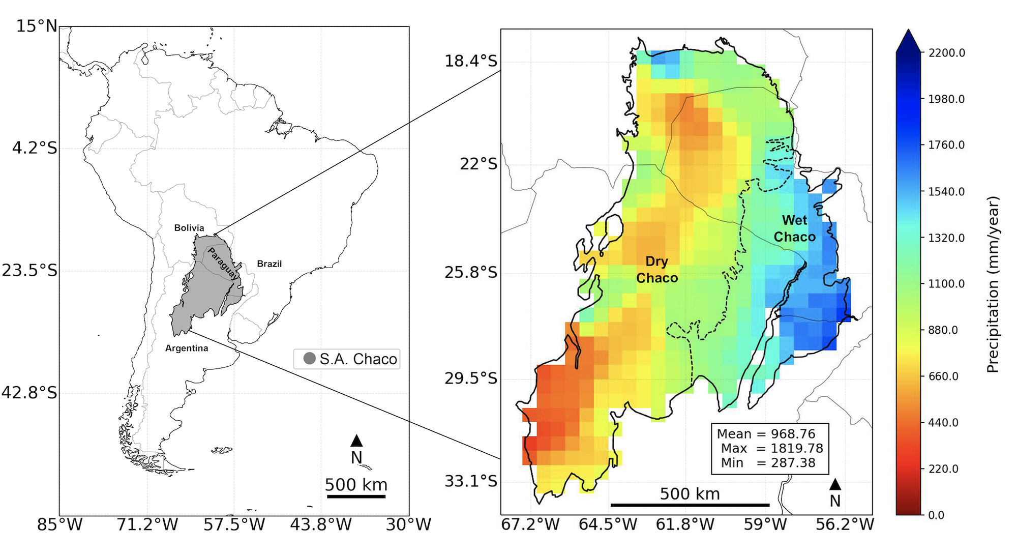
The study focussed on the South America Chaco, a 1.1million km2 area spanning Argentina, Bolivia, Paraguay and Brazil. It is home to the largest, and one of the world’s last remaining, tropical dry forests and is a significant continental carbon stock.
Since the 1980s the region has experienced substantial loss of tree cover, with the situation deteriorating considerably in 2020 following serious wildfires.
To quantify the pattern of fire disturbance and investigate the drivers, lead author Rodrigo San Martin from the LSCE, examined regional meteorological data and satellite observations of burned area and land cover for the 2001-2019 study period.
Drivers – climate, land cover or humans?
In contrast to many fire regime studies in other parts of the world, the team did not find a significant or gradual increase in the fire frequency or duration of the fire seasons throughout the last 20 years. They did however observe distinct patterns of fire activity across the arid west – the Dry Chaco – and wetter eastern subregion, which suggests factors other than climate or meteorology play an important role.
The Wet Chaco to the east was found to exhibit two seasonal peaks while the arid west experiencing only a single peak during the winter-spring dry season and suggests something other than climate is at play.
Mr San Martin explains:
“Although we found some negative relationships between extremely wet years and burnt area, just looking solely at the meteorology of the whole Chaco we would not be able to predict the different fire annual cycles we find for each subregion.
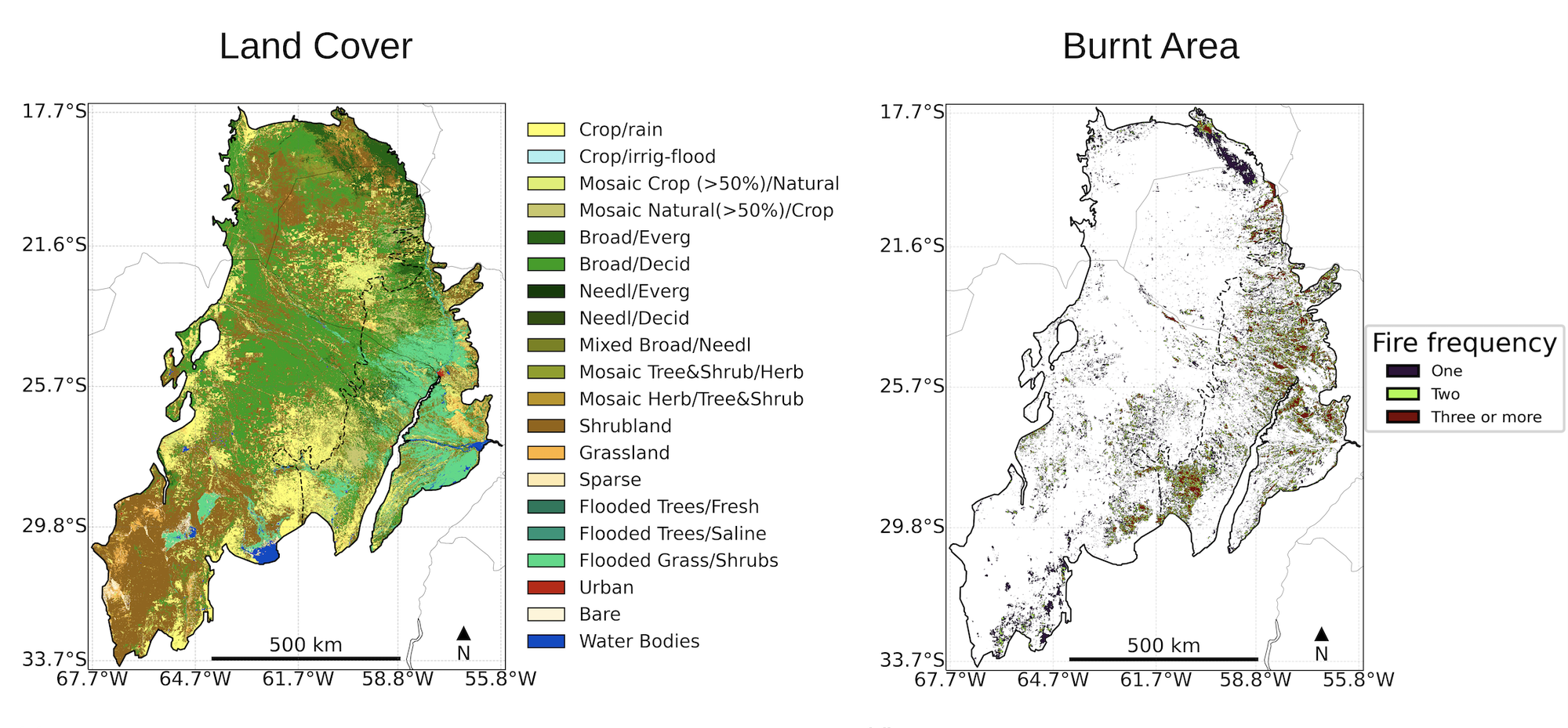
“Only when adding the land cover layer to the analysis were we able to interpret the different pattern of fire behaviour between the predominantly xerophytic woody vegetation found in the Dry Chaco and the herbaceous grasses and seasonally flooded vegetation in the Wet Chaco.”
The greater biomass production from the Wet Chaco’s grasses and savannahs of present a greater ‘two-peak fire risk. In contrast, slower rate of biomass accumulation in in the Dry Chaco only becomes a fire risk in the late winter-early spring.
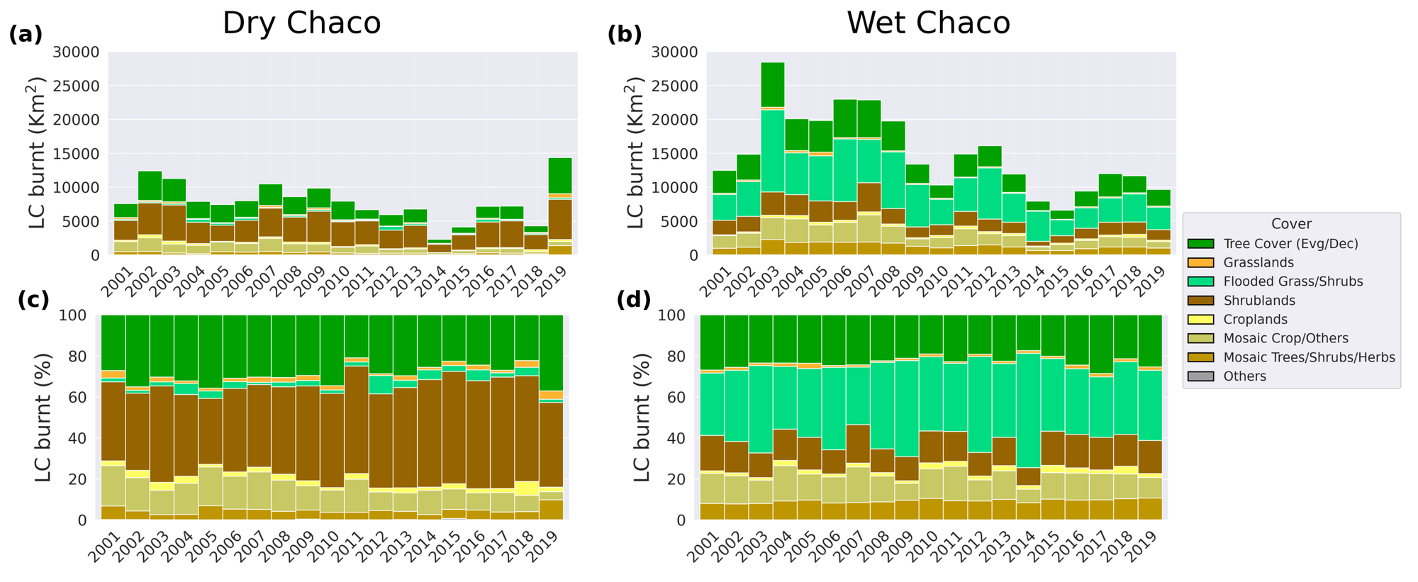
Most interestingly for the lead author, the team found that tree losses are comparatively greater in the Dry Chaco despite a similar coincidence between tree covered area and burn patches. The data points to a potential connection to land use, management and policy.
The difference in the coincidence of fire and deforestation across the national borders was stark. Forty percent of the tree losses in Argentina for example coincided with fire detection in contrast to less than 8% for Bolivia. This indicates that fire is used to differing extents as a tool to clear forests for other land uses according to the study authors.
“We found a time lag we observed between deforestation and fires in the Dry Chaco. This put into evidence that deforestation is mainly carried out with machines rather than through fire and that the dead biomass is either used or burnt one to three years later after it dries out,” explains Mr San Martin.
Consistent satellite data
The satellite records used are freely available via ESA’s Climate Change Initiative (CCI) as part of a suite of global satellite records for over 20 key climate variables. The fire product (FireCCI51), derived from the MODIS sensor data and with a 250-m resolution is capable of detecting relatively small burn patches. The land cover product provides annual maps at 300m resolution and follows the United Nations Food and Agriculture Organisations classification system.
Mr San Martin explains why he opted to use ESA’s satellite products in this study:
“We found several advantages to working with ESA CCI data products compared to others. The higher spatial resolution of the Fire and Land Cover products and their good temporal coverage proved ideal for the analysis. The correspondence between the fire and land cover products was particularly beneficial good more robust temporal consistency, a crucial factor for our needs.”
ESA CCI data records are fully uncertainty characterised, validated by in-situ data to and are suited for climate science and climate modelling communities.
The study is published in the journal Fire Ecology and highlights the added value of generating satellite datasets that address GCOS-defined Essential Climate Variables - to investigate and address Earth system-related complex science challenges.
Reference
San Martín et al. Fire Ecology (2023)https://doi.org/10.1186/s42408-023-00212-4