
Summary
African cities are facing growing exposure to climate risks such as extreme heat and flooding, with rapidly expanding urban populations that have limited adaptive capacity.
The CAIAC project harnesses Earth Observation data to enhance simulations of urban climate conditions, improving scientific understanding of climate extremes and their impacts. Its findings will inform global climate assessments, including the forthcoming IPCC Special Report on Climate Change and Cities, and support the management of urban climate risks in Africa.
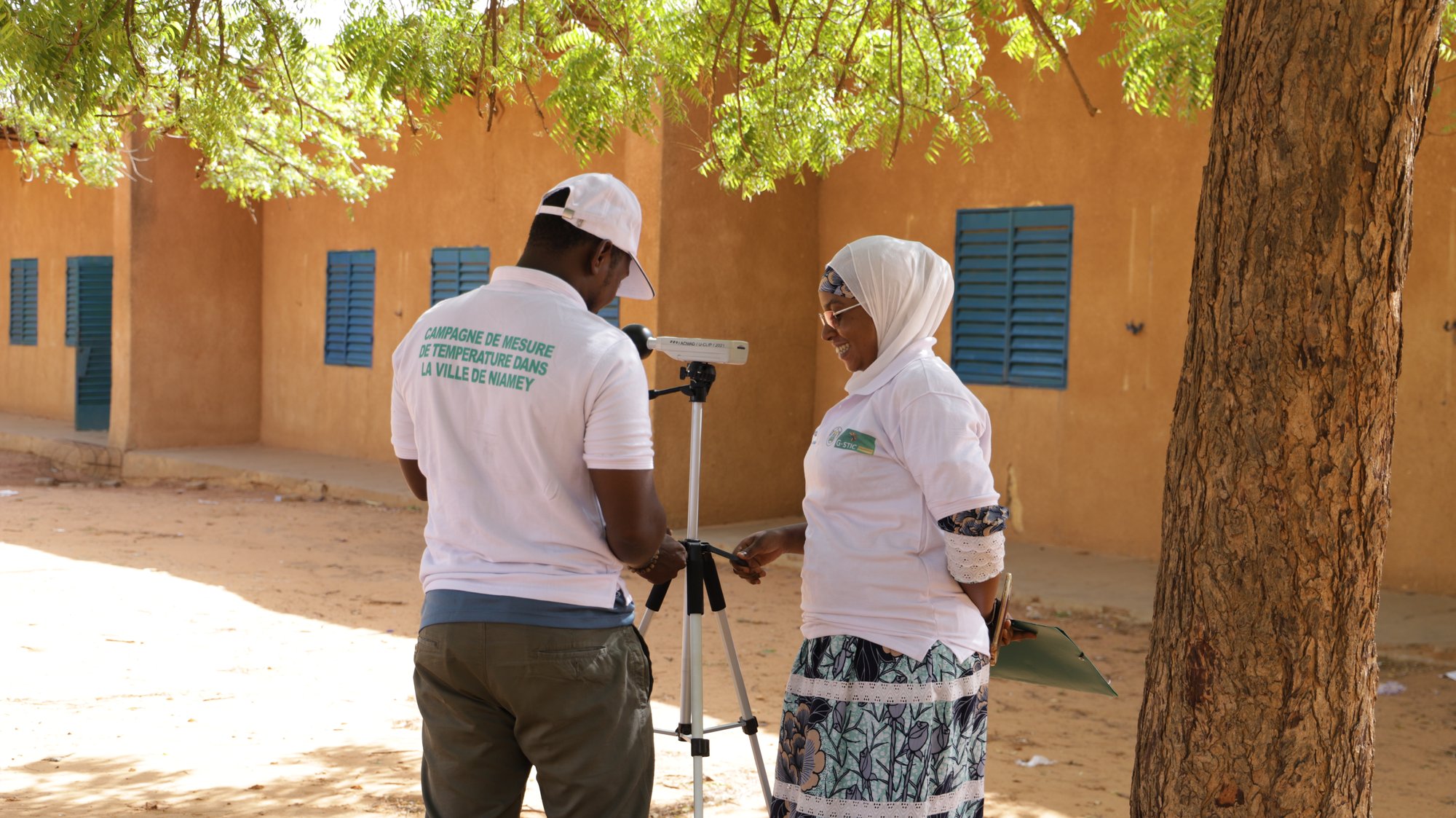
Throughout the project, we work closely with local stakeholders to ensure that outputs reflect urban realities and incorporate on-the-ground perspectives.
Project background
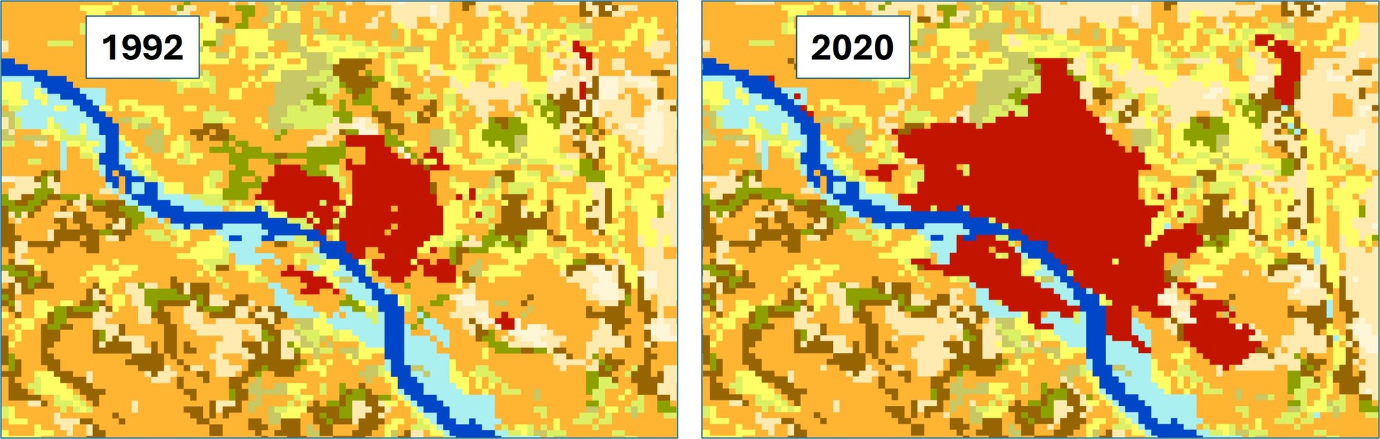
African cities are increasingly exposed to climate extremes such as heatwaves and flooding, placing populations and infrastructure at risk. Rapid urban growth further amplifies these challenges, as expansion often occurs in vulnerable areas with limited protective infrastructure. Policymakers urgently need reliable information to guide urban planning, protect communities, and strengthen resilience. Yet such evidence remains scarce at the fine scales required for decision-making, creating a major policy challenge: most adaptation measures are implemented without robust evidence on the evolving risks faced by urban populations.
The scientific challenge is rooted in persistent gaps in observing and modelling urban climates. Traditional climate models are too coarse to capture city-level processes, while in situ networks across Africa are sparse and uneven. This has left major uncertainties in understanding how climate change interacts with rapid urbanisation. The lack of consistent, long-term observations hampers both the monitoring of current conditions and the validation of high-resolution urban climate models.
Earth Observation (EO) provides a critical means of addressing these challenges. Satellite data offer unique, spatially consistent information on land cover, surface temperatures, hydrology, and urban expansion, all of which are essential to characterise how cities experience and amplify climate extremes. EO is indispensable for filling observational gaps, providing continent-wide coverage, and enabling the systematic analysis of urban climate risks in places where ground-based measurements are lacking.
At the international level, the IPCC has mandated a forthcoming Special Report on Climate Change and Cities (https://www.ipcc.ch/report/special-report-on-climate-change-and-cities/). This report will depend on new scientific evidence, especially from rapidly growing regions such as Africa, where current knowledge is most limited. The policy challenge is therefore not only local but global: without African urban evidence, international assessments will underrepresent some of the most vulnerable populations.
In summary, the challenge that CAIAC addresses is twofold:
- the policy gap, where city authorities lack reliable, fine-scale information to guide adaptation; and
- the scientific gap, where urban climate processes remain poorly monitored and modelled.
EO stands out as a transformative tool to close both gaps, providing the consistent, scalable evidence base needed to inform urban resilience strategies and international climate assessments alike.
Aims and Objectives
Aim
The project aims to leverage Earth Observation data to enhance simulations of urban climate conditions — particularly extreme heat and flooding — in Africa’s rapidly expanding cities. This will address an information gap and generate valuable knowledge and datasets, supporting efforts to better understand and manage urban climate risks in African cities and provide essential scientific evidence to inform global assessments, including the forthcoming IPCC Special Report on Climate Change and Cities.
Objectives
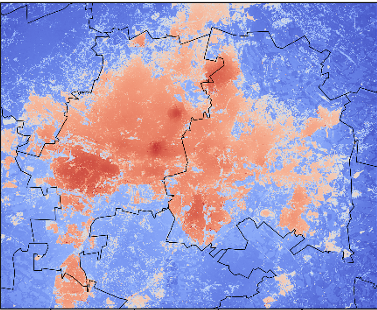
- To generate climate projections at medium spatial resolution (c 300 m) suited to capture urban dynamics. This will be achieved by integrating EO-based land cover datasets with UrbClim - a physics-based model for simulating urban heat, and SAHEL- a machine learning ensemble model for flood mapping. Together, these tools will deliver multi-decadal simulations of temperature, humidity, and flooding conditions across a wide variety of African urban environments.
- Incorporate EO-guided urban growth projections to ensure that future climate simulations realistically reflect the rapid expansion of African cities. Multi-annual ESA Essential Climate Variable (ECV) Land Cover products, combined with VITO’s GeoDynamiX tool, will drive spatially explicit scenarios of urban development. These scenarios will be aligned with Shared Socioeconomic Pathways (SSPs), ensuring consistency with global climate trajectories and demographic projections.
- To establish a comprehensive validation and uncertainty framework. Past simulations will be benchmarked against both in-situ observations and satellite-derived datasets such as land surface temperature and flood maps derived from Sentinel-1. Bias correction and Monte Carlo techniques will be employed to quantify and propagate uncertainties, ensuring robust conclusions for both past reconstructions and future projections.
- Undertake a risk analysis of urban exposure and vulnerability to extreme heat and flooding. This may involve deriving thermal comfort indices, calculating population exposure metrics, estimating the cooling capacity of urban green vegetation, or assessing socio-economic impacts. By analysing more than 50 cities across the continent, including capital cities, secondary centres, and geographically significant urban areas, the project will generate novel insights into urban climate risks.
Project plan
The project plan follows 4 steps
- Review of the state of the art, knowledge gaps, and user needs. The project will start with a review of existing knowledge on climate change impacts in cities, with a focus on data-scarce regions in Africa. A literature review will assess studies on urban heat islands, flooding, and other climate hazards, identifying critical gaps. An inventory of relevant datasets, including ESA’s Climate Change Initiative (CCI) Essential Climate Variables (ECVs) and other remote sensing products, will be compiled to ensure robust input for later analyses. Key scientific requirements will be derived, and feasibility will be confirmed by cross-referencing gaps with available datasets and methodologies.
2. Development of methodology for scientific analysis. A dedicated phase will define the methodology, ensuring alignment with project objectives and the availability of high-quality EO and climate model datasets. The approach will integrate satellite-based climate data with urban climate models, using ESA CCI products for land cover, land surface temperature, and hydrologic parameters. Downscaling techniques will help bridge the gap between global climate models and city-scale dynamics. Input datasets will undergo critical evaluation for accuracy, completeness, and suitability.
3. Core scientific activities and uncertainty assessment. The core activities will simulate climate impacts in African cities under future scenarios, explicitly considering urban growth through the GeoDynamiX tool. Interactions between urban expansion and climate change will be quantified to assess combined effects on temperature extremes and flood risk. Remote sensing data will be integrated with the UrbClim physics-based model and the SAHEL machine-learning model for flood assessment. An uncertainty framework will address variability in climate projections, data reliability, and socio-economic urbanisation trends. Results will be validated against in-situ data and historical satellite observations.
4. Scientific roadmap and data-sharing. A scientific roadmap will guide the transition of results into operational frameworks and climate services. It will outline pathways for scaling the methodology across cities and climates. An open-access data-sharing strategy will ensure model outputs, datasets, and tools are available to researchers and stakeholders. Key aspects of operationalisation, such as processing pipelines and computational infrastructure, will be addressed, while long-term sustainability will be explored with end-users including meteorological services and urban planners.
Effective management, stakeholder engagement, and dissemination will ensure timely delivery and impact. Outreach will target scientists, policymakers, and international initiatives through workshops, conferences, and publications. Engagement with African stakeholders will ensure results support real-world adaptation needs and climate-resilient urban planning.