
The “sea state” is the statistical description of wind-generated ocean wave properties, including their heights, periods and directions. Waves associated with the local wind form the wind sea, and waves propagating from remote storms are swells. The “sea state climate” is needed in all ocean and coastal engineering applications. The expected extremes over the lifetime of ships, platforms or coastal defences are of particular interest. Ocean waves contribute to sediment transport and extreme sea levels at the coast, the evolution of sea ice, and air-sea fluxes. Finally, ocean waves cause biases and random errors in the satellite measurement of other variables such as sea level.
The project will particularly focus on reducing the noise of sea state parameters, and combining seamlessly different satellite sensors, including the latest Doppler processing of altimeters. Synthetic Aperture Radars are particularly useful for swell properties and are unique in providing swell directions. Because waves are generated by the wind over the open ocean, the sea state climate varies with large scale climate patterns, such as El Niños, and trends. The project database will thus be analysed to identify these patterns in order to help understand ongoing changes in sea state climate.
Objective
The ultimate objective of SeaState_cci is to develop an 18-year data set (2002- 2020) capitalising on the rich satellite altimeter, SAR imager, in situ and other data holdings available during that period. The focus will be on the development, testing and improvement of dedicated sea state retrieval algorithms with respect to climate users' requirements, as compiled at high level by GCOS.
About the project
We start from observation requirements laid out by GCOS, and the needs of both the climate research community, which are particularly laid out in the COWCLIP publications, and key applications communities that include coastal management and shipping. These requirements will be refined and evolved as part of the project.
Of primary concern will be the accuracy and stability of the data set that we will produce. These include
- Significant wave height from satellite altimeters that include all the ESA missions, and Topex/Jason series.
- Wave spectra from radar imagery: all wave mode from ERS to Sentinel 1 and a sample of larger image mode data.
Sea state has never been the main focus of satellite altimetry. Except for the results of the Globwave project and new Copernicus Marine Environment Monitoring Service activities, wind and wave parameters from altimeters were a by-product of sea level estimates, leading to inconsistencies between sensors and satellite missions. Our project will thus carry out algorithm development to ensure the best possible quality of wave and wind products with a particular focus on consistency.
A particular challenge is posed by the strong evolution of measurement techniques, in particular going from Range-only to Delay-Doppler processing, and we will work towards harmonizing the processing to arrive at seamless products than span the years 2003 to 2020 as part of this project, and making possible longer time series in a future phase 2. The data production system will be fully documented, making future transfer possible.
The project will provide time series of wave parameters (by mission - level 2, and consolidated - level 3) and gridded analyses of wave climate parameters (level 4). Based on these products we will work with the Earth observation and climate science community to identify and better analyse key processes that contribute to uncertainties in other ECVs (primarily sea ice and sea level). We will also work with the seismology community to make better use of microseism data for wave event detection and sea state trends analyses. These efforts should contribute to improved sea state models that are now used by seismologists for solid Earth monitoring and tomography.
The Project results, from the new algorithms, to the data set and their application in key areas will published in world class peer-reviewed scientific journals, in particular in time to contribute to IPCC Assessment Reports.
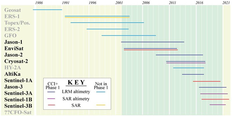
Figure: Schematic showing operating lifetime of relevant satellite sensors, indicating which ones will be processed in Phase 1 of CCI+. (Illustration adapted from Shutler et al., 2016.)
Access and search ESA Climate Change Initiative data products, including those from teh Sea Surface Salinity project via our dedicate Open Data Portal
ESA Sea State Climate Change Initiative data products (version 3)
- RA Level 2P Product – Global remote sensing multi-mission along-track significant wave height from altimetry, L2P product, release version 3 http://dx.doi.org/10.5285/8cb46a5efaa74032bf1833438f499cc3
- RA Level 3 Product – Global remote sensing daily merged multi-mission along-track significant wave height from altimetry, L3 product, release version 3 http://dx.doi.org/10.5285/e6af67fca81c40b7bb3eddaadde06909
- RA Level 4 Product – Global remote sensing merged multi-mission monthly gridded significant wave height from altimetry, L4 product, release version 3 http://dx.doi.org/10.5285/9c350d4ff7ee438f9f1fc7252cbb2282
- SAR ISSP ENVISAT Level 2P Product – Global remote sensing multi-mission along-track Integrated Sea State Parameters (ISSP) from SAR Wave Mode onboard ENVISAT, L2P product, release version 3 http://dx.doi.org/10.5285/8cd1a9beabc648c8a2c91fa68791d9d7
- SAR ISSP S-1A & 1B Level 2P Product – Global remote sensing multi-mission along-track Integrated Sea State Parameters (ISSP) from SAR WV onboard Sentinel-1A & 1B, L2P product, release version 3 http://dx.doi.org/10.5285/fe02d5eef9ef4ad889d1917ccad3b35f
- SAR SWH S-1A & 1B Level 2P Product – Global remote sensing multi-mission along-track significant wave height (SWH) from SAR WV onboard Sentinel-1A & 1B, L2P product, release version 3 http://dx.doi.org/10.5285/81bab8b378db443db4482a5961a58ec1
ESA Sea State Climate Change Initiative data products (version 1.1)
- Level 2P Product – Global remote sensing multi-mission along-track significant wave height, L2P product, version 1.1 http://dx.doi.org/10.5285/f91cd3ee7b6243d5b7d41b9beaf397e1
- Level 3 Product – Global remote sensing daily merged multi-mission along-track significant wave height, L3 product, version 1.1 http://dx.doi.org/10.5285/3ef6a5a66e9947d39b356251909dc12b
- Level 4 Product – Global remote sensing merged multi-mission monthly gridded significant wave height, L4 product, version 1.1 http://dx.doi.org/10.5285/47140d618dcc40309e1edbca7e773478
The Sea State_cci consortium is based on a close collaboration between the following partners:
- Laboratory for Ocean Physics and Satellite remote sensing (LOPS) [FR] (primary)
- Institut français de recherche pour l'exploitation de la mer (Ifremer) [FR]
- OceanDataLab [FR]
- Collecte Localisation Satellites (CLS) [FR]
- Institut de Physique du Globe de Paris (IPGP) [FR]
- Technical University of Munich (TUM) [DE]
- Researchers at the German Aerospace Center (DLR) [DE]
- Plymouth Marine Laboratory (PML) [UK]
- National Oceanography Centre (NOC) [UK]
- Satellite Oceanography Consultants (SatOC) [UK]
- European Centre for Medium-Range Weather Forecasts [UK]
Publications produced by the Sea State CCI team.
In press
Collard, F., Marie, L., Nouguier, F., Kleinherenbrink, M., Ehlers, F., Ardhuin, F., (in press, J. Geophys. Res. Oceans). Wind-wave attenuation under sea ice in the Arctic: a review of remote sensing capabilities. Preprint at https://doi.org/10.1002/essoar.10510961.1
2022
Dodet, G., Abdalla, S., Alday, M., Accensi, M., Bidlot, J., Ardhuin, F., 2022. Error characterization of significant wave heights in multi-decadal satellite altimeter product, model hindcast and in situ measurements, using triple collocation technique. Journal of Atmospheric and Oceanic Technology 1. https://doi.org/10.1175/JTECH-D-21-0179.1
Schlembach, F., Passaro, M., Dettmering, D., Bidlot, J., Seitz, F., 2022. Interference-sensitive coastal SAR altimetry retracking strategy for measuring significant wave height. Remote Sensing of Environment 274, 112968. https://doi.org/10.1016/j.rse.2022.112968
Pleskachevsky, A., Tings, B., Wiehle, S., Imber, J., Jacobsen, S., 2022. Multiparametric sea state fields from synthetic aperture radar for maritime situational awareness. Remote Sensing of Environment 280, 113200. https://doi.org/10.1016/j.rse.2022.113200
2021
Alday, M., Accensi, M., Ardhuin, F., Dodet, G., 2021. A global wave parameter database for geophysical applications. Part 3: Improved forcing and spectral resolution. Ocean Modelling 166, 101848. https://doi.org/10.1016/j.ocemod.2021.101848
Hochet, A., Dodet, G., Ardhuin, F., Hemer, M., Young, I., 2021. Sea State Decadal Variability in the North Atlantic: A Review. Climate 9, 173. https://doi.org/10.3390/cli9120173
Marechal, G., Ardhuin, F., 2021. Surface Currents and Significant Wave Height Gradients: Matching Numerical Models and High-Resolution Altimeter Wave Heights in the Agulhas Current Region. Journal of Geophysical Research: Oceans 126, e2020JC016564. https://doi.org/10.1029/2020JC016564
Passaro, M., Hemer, M.A., Quartly, G.D., Schwatke, C., Dettmering, D., Seitz, F., 2021. Global coastal attenuation of wind-waves observed with radar altimetry. Nat Commun 12, 3812. https://doi.org/10.1038/s41467-021-23982-4
Quartly, G.D., Chen, G., Nencioli, F., Morrow, R., Picot, N., 2021. An Overview of Requirements, Procedures and Current Advances in the Calibration/Validation of Radar Altimeters. Remote Sensing 13, 125. https://doi.org/10.3390/rs13010125
Rusu, L., Rusu, E., 2021. Evaluation of the Worldwide Wave Energy Distribution Based on ERA5 Data and Altimeter Measurements. Energies 14, 394. https://doi.org/10.3390/en14020394
Rusu, E., Rusu, L., 2021. An evaluation of the wave energy resources in the proximity of the wind farms operating in the North Sea. Energy Reports, 2021 6th International Conference on Advances on Clean Energy Research 7, 19–27. https://doi.org/10.1016/j.egyr.2021.05.058
Rusu, L., Onea, F., Rusu, E., 2021. The Expected Impact of Marine Energy Farms Operating in Island Environments with Mild Wave Energy Resources—A Case Study in the Mediterranean Sea. Inventions 6, 33. https://doi.org/10.3390/inventions6020033
Schlembach, F., Passaro, M., Quartly, G.D., Kurekin, A., Nencioli, F., Dodet, G., Piollé, J.-F., Ardhuin, F., Bidlot, J., Schwatke, C., Seitz, F., Cipollini, P., Donlon, C., 2021. Correction: Schlembach, F., et al. Round Robin Assessment of Radar Altimeter Low Resolution Mode and Delay-Doppler Retracking Algorithms for Significant Wave Height. Remote Sens. 2020, 12, 1254. Remote Sensing 13, 1182. https://doi.org/10.3390/rs13061182
Scott, T., McCarroll, R.J., Masselink, G., Castelle, B., Dodet, G., Saulter, A., Scaife, A.A., Dunstone, N., 2021. Role of Atmospheric Indices in Describing Inshore Directional Wave Climate in the United Kingdom and Ireland. Earth’s Future 9, e2020EF001625. https://doi.org/10.1029/2020EF001625
Stopa, J.E., 2021. Seasonality of wind speeds and wave heights from 30 years of satellite altimetry. Advances in Space Research, 25 Years of Progress in Radar Altimetry 68, 787–801. https://doi.org/10.1016/j.asr.2019.09.057
2020
Ardhuin, F., Otero, M., Merrifield, S., Grouazel, A., Terrill, E., 2020. Ice Breakup Controls Dissipation of Wind Waves Across Southern Ocean Sea Ice. Geophysical Research Letters 47, e2020GL087699. https://doi.org/10.1029/2020GL087699
Bôas, A.B.V., Cornuelle, B.D., Mazloff, M.R., Gille, S.T., Ardhuin, F., 2020. Wave–Current Interactions at Meso- and Submesoscales: Insights from Idealized Numerical Simulations. Journal of Physical Oceanography 50, 3483–3500. https://doi.org/10.1175/JPO-D-20-0151.1
Cox, R., Ardhuin, F., Dias, F., Autret, R., Beisiegel, N., Earlie, C.S., Herterich, J.G., Kennedy, A., Paris, R., Raby, A., Schmitt, P., Weiss, R., 2020. Systematic Review Shows That Work Done by Storm Waves Can Be Misinterpreted as Tsunami-Related Because Commonly Used Hydrodynamic Equations Are Flawed. Frontiers in Marine Science 7.
Dodet, G., Piolle, J.-F., Quilfen, Y., Abdalla, S., Accensi, M., Ardhuin, F., Ash, E., Bidlot, J.-R., Gommenginger, C., Marechal, G., Passaro, M., Quartly, G., Stopa, J., Timmermans, B., Young, I., Cipollini, P., Donlon, C., 2020. The Sea State CCI dataset v1: towards a sea state climate data record based on satellite observations. Earth System Science Data 12, 1929–1951. https://doi.org/10.5194/essd-12-1929-2020
Lecocq, T., Ardhuin, F., Collin, F., Camelbeeck, T., 2020. On the Extraction of Microseismic Ground Motion from Analog Seismograms for the Validation of Ocean‐Climate Models. Seismological Research Letters 91, 1518–1530. https://doi.org/10.1785/0220190276
Popp, T., Hegglin, M.I., Hollmann, R., Ardhuin, F., Bartsch, A., Bastos, A., Bennett, V., Boutin, J., Brockmann, C., Buchwitz, M., Chuvieco, E., Ciais, P., Dorigo, W., Ghent, D., Jones, R., Lavergne, T., Merchant, C.J., Meyssignac, B., Paul, F., Quegan, S., Sathyendranath, S., Scanlon, T., Schröder, M., Simis, S.G.H., Willén, U., 2020. Consistency of Satellite Climate Data Records for Earth System Monitoring. Bulletin of the American Meteorological Society 101, E1948–E1971. https://doi.org/10.1175/BAMS-D-19-0127.1
Quartly, G.D., Kurekin, A.A., 2020. Sensitivity of Altimeter Wave Height Assessment to Data Selection. Remote Sensing 12, 2608. https://doi.org/10.3390/rs12162608
Quilfen, Y., Chapron, B., 2020. On denoising satellite altimeter measurements for high-resolution geophysical signal analysis. Advances in Space Research. https://doi.org/10.1016/j.asr.2020.01.005
Rusu, L., 2020. A projection of the expected wave power in the Black Sea until the end of the 21st century. Renewable Energy 160, 136–147. https://doi.org/10.1016/j.renene.2020.06.092
Timmermans, B.W., Gommenginger, C.P., Dodet, G., Bidlot, J.-R., 2020. Global Wave Height Trends and Variability from New Multimission Satellite Altimeter Products, Reanalyses, and Wave Buoys. Geophysical Research Letters 47, e2019GL086880. https://doi.org/10.1029/2019GL086880
Timmermans, B., Shaw, A.G.P., Gommenginger, C., 2020. Reliability of Extreme Significant Wave Height Estimation from Satellite Altimetry and In Situ Measurements in the Coastal Zone. Journal of Marine Science and Engineering 8, 1039. https://doi.org/10.3390/jmse8121039
Schlembach, F., Passaro, M., Quartly, G.D., Kurekin, A., Nencioli, F., Dodet, G., Piollé, J.-F., Ardhuin, F., Bidlot, J., Schwatke, C., Seitz, F., Cipollini, P., Donlon, C., 2020. Round Robin Assessment of Radar Altimeter Low Resolution Mode and Delay-Doppler Retracking Algorithms for Significant Wave Height. Remote Sensing 12, 1254. https://doi.org/10.3390/rs12081254
2019
Ardhuin, F., Stopa, J.E., Chapron, B., Collard, F., Husson, R., Jensen, R.E., Johannessen, J., Mouche, A., Passaro, M., Quartly, G.D., Swail, V., Young, I., 2019. Observing Sea States. Front. Mar. Sci. 6. https://doi.org/10.3389/fmars.2019.00124
Dodet, G., Melet, A., Ardhuin, F., Bertin, X., Idier, D., Almar, R., 2019. The Contribution of Wind-Generated Waves to Coastal Sea-Level Changes. Surv Geophys. https://doi.org/10.1007/s10712-019-09557-5
Dobler, D., Huck, T., Maes, C., Grima, N., Blanke, B., Martinez, E., Ardhuin, F., 2019. Large impact of Stokes drift on the fate of surface floating debris in the South Indian Basin. Marine Pollution Bulletin 148, 202–209. https://doi.org/10.1016/j.marpolbul.2019.07.057
Morrow, R., Fu, L.-L., Ardhuin, F., Benkiran, M., Chapron, B., Cosme, E., d’Ovidio, F., Farrar, J.T., Gille, S.T., Lapeyre, G., Le Traon, P.-Y., Pascual, A., Ponte, A., Qiu, B., Rascle, N., Ubelmann, C., Wang, J., Zaron, E.D., 2019. Global Observations of Fine-Scale Ocean Surface Topography With the Surface Water and Ocean Topography (SWOT) Mission. Frontiers in Marine Science 6.https://doi.org/10.3389/fmars.2019.00232
Stopa, J. E., Ardhuin, F., Stutzmann, E., & Lecocq, T. (2019). Sea state trends and variability: Consistency between models, altimeters, buoys, and seismic data (1979–2016). Journal of Geophysical Research: Oceans, 124. https://doi.org/10.1029/2018JC014607
Villas Bôas, A.B., Ardhuin, F., Ayet, A., Bourassa, M.A., Brandt, P., Chapron, B., Cornuelle, B.D., Farrar, J.T., Fewings, M.R., Fox-Kemper, B., Gille, S.T., Gommenginger, C., Heimbach, P., Hell, M.C., Li, Q., Mazloff, M.R., Merrifield, S.T., Mouche, A., Rio, M.H., Rodriguez, E., Shutler, J.D., Subramanian, A.C., Terrill, E.J., Tsamados, M., Ubelmann, C., van Sebille, E., 2019. Integrated Observations of Global Surface Winds, Currents, and Waves: Requirements and Challenges for the Next Decade. Frontiers in Marine Science 6. https://doi.org/10.3389/fmars.2019.00425
ESA's Sea State CCI held its 2nd User Consultation Meeting (UCM) on 23rd-25th March 2021. This was purely an online event, with presentations over Webex, and posters available using padlets. There is a Book of Abstracts, whilst a full list of the presentations (with PDFs of most of them) is given below.


The following people can be contacted within the Sea State project.
- Scientific Leader: Fabrice Ardhuin – ardhuin@ifremer.fr
- Project Manager (Phase 1): Ellis Ash – e.ash@satoc.eu
- Project Manager (Phase 2): Annabelle Ollivier - aollivier@groupcls.com
- ESA Technical Officer (Phase 1): Craig Donlon – craig.donlon@esa.int (supported by Paolo Cipollini – paolo.cipollini@esa.int)
- ESA Technical Officer (Phase 2): Sarah Connors - sarah.connors@esa.int
The following links provide supporting graphics and animations relating to the Sea Sea State project:
Significant Wave Height:
https://www.youtube.com/watch?v=2h17DLkbV3Q
Oceans and climate:
https://www.esa.int/ESA_Multimedia/Videos/2022/05/Oceans_and_climate


