
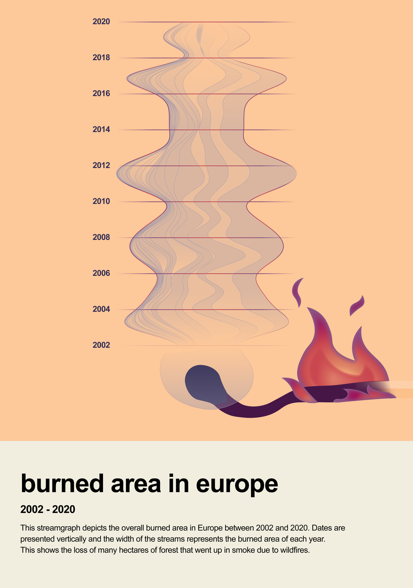
This streamgraph depicts the overall burned area in Europe between 2002 and 2020. Dates are presented vertically and the width of the streams
represents the burned area of each year to show the loss of many hectares of vegetation that 'went up in smoke' due to wildfires.
About
This Little Picture depicts the overall burned area in Europe between 2002 and 2020 using satellite data from the ESA Climate Change Initiative Fire project. Dates are presented vertically and the width of the streams represents the burned area of each year. Fire disturbance and the resulting biomass burning contributes aerosols and greenhouse gas emissions to the atmosphere and is considered as one of 54 Essential Climate Variables by the Global Climate Observing System that are used to characterise the Earth system.
Judges commendations
- 'Novel. Fun idea to combine the steamgraph with the match for fire related data'
- 'Stunning metaphor - emotional,
Data
The Little Picture uses data from the ESA Climate Change Initiative Fire project. Chuvieco, E.; Pettinari, M.L.; Lizundia Loiola, J.; Storm, T.; Padilla Parellada, M. (2019): ESA Fire Climate Change Initiative (Fire_cci): MODIS Fire_cci Burned Area Grid product, version 5.1. Centre for Environmental Data Analysis, 08 February 2019. doi:10.5285/3628cb2fdba443588155e15dee8e5352. https://dx.doi.org/10.5285/3628cb2fdba443588155e15dee8e535
Code
No scripts were produced to generate this Little Picture. Anne-Lise generated her streamograph using a pre-prepared CSV file. Cumulative sums were generated using the rawgraphs (https://app.rawgraphs.io/) website. She then stylised the image using Adobe Illustrator to give its overall look (colors and drawing).
Licence
This Little Picture is published under CC BY-SA 4.0 licence.
The big picture
The European Space Agency (ESA), the European Centre for Medium-Range Weather Forecasts (ECMWF), and the European Organisation for the Exploitation of Meteorological Satellites (EUMETSAT) work closely together to measure, process & make space-derived information about the climate available.
ESA
The mission of the Climate Change Initiative (CCI) is to realise the full potential of the long-term global Earth Observation archives that the European Space Agency (ESA), together with its Member states, has established over the past 40 years, as a significant and timely contribution to the climate databases required by the United Nations Framework Convention on Climate Change. The ESA Climate Office provides a free & open CCI data facility bringing together ECV data from across its twenty-seven climate science projects, including a CCI Data Standards and a CCI Toolbox.
ECMWF
The Copernicus Climate Change Service (C3S) supports society by providing freely available authoritative information about the past, present and future climate in Europe and the rest of the World. C3S is one of the six thematic information services provided by the Copernicus Earth Observation Programme of the European Union, and has been entrusted by the European Commission to the European Centre for Medium-Range Weather Forecasts (ECMWF). One of the core components of C3S includes the Climate Data Store (CDS). This is a one-stop shop for climate information. It provides free and easy access to a wide range of climate datasets via a searchable catalogue. A freely available online toolbox allows users to build workflows and applications suited to their needs.
EUMETSAT
EUMETSAT operates missions both to provide weather and climate data for its member states, and as an entrusted entity under the Copernicus programme. Several missions are operated collaboratively with ESA, providing complimentary expertise and data processing, to process and distribute land, marine, and atmosphere relevant products for users. Data from EUMETSAT operated missions is frequently available in near-real-time, facilitating rapid monitoring and forecasting. Via EUMETCast, the EUMETSAT Data Services, or WEkEO, users can access data in ways that suit their needs. The data is used by the EUMETSAT satellite applications facilities, as well as across the various Copernicus Services.
next