Lakes and enclosed inland seas are integrators of environmental and climatic changes occurring within their contributing basins. Factors driving lake condition vary widely across space and time, and lakes, in turn, play an important role in local and global climate regulation, with positive and negative feedback depending on the catchment. Understanding the complex behaviour of lakes in a changing environment is essential to effective water resource management and mitigation of climate change effects.
Lakes have been observed as sentinels of climate change, both directly and indirectly through watershed changes. Lakes integrate responses over time and studies of globally distributed lakes can capture different aspects of climate change. Therefore, a global and consistent climate data record of lakes is essential to mitigate and adapt to climate change.
The Lakes_cci project develops satellite-derived products for the Lakes Essential Climate Variable, as defined by GCOS-200:
- Lake Water Level (LWL): fundamental to understand the balance between water inputs and water loss.
- Lake Water Extent (LWE): a proxy for change in glacial regions (lake expansion) and drought in many arid environments, water extent relates to local climate for the cooling effect that water bodies provide.
- Lake Surface Water temperature (LSWT): correlated with regional air temperatures and a proxy for mixing regimes, driving biogeochemical cycling and seasonality.
- Lake Ice Cover (LIC): freeze-up in autumn and advancing break-up in spring are proxies for gradually changing climate patterns and seasonality.
- Lake Ice Thickness (LIT): a driver of seasonal lake biogeochemistry and early indicator of changing lake thermodynamics. This product, is being evaluated and upscaled during the current project phase.
- Lake Water-Leaving Reflectance (LWLR): a direct indicator of biogeochemical processes and habitats in the visible part of the water column (e.g. seasonal phytoplankton biomass fluctuations), and an indicator of the frequency of extreme events (peak terrestrial run-off, changing mixing conditions).
Objectives
The overarching objective of the Lakes project is to produce and validate a consistent data set of the variables grouped under the Lakes ECV. This includes aiming for the longest period of combined satellite observations by designing and operating processing chains, designed to ultimately feature in a sustainable production system.
The main ambition associated with this objective is to establish wide uptake by a varied and fragmented landscape of potential users. This requires significant alignment of current practices for producing the individual Lake variables, cross-variable validation, and demonstration in the form of use cases. Successfully tackling the challenge of producing a single data set for the Lakes ECV creates an opportunity to move the science community towards wider uptake of Earth Observation data in limnological studies.
To achieve this global objective, the specific objectives for the Lakes project are to:
- Assess the requirements of the climate research community and thereby ensure consistency in the (further) development of the Lakes ECV processing system. The criteria will be revisited to propose complementary groups of lakes for each of the lake ECV products.
- Develop, test and select the best algorithms and standards to produce high quality Lake products for climate applications across sensors. A range of algorithms and methods will be assessed to yield the longest possible period of observations for each variable, and the largest possible subset of lakes for which a complete set of variables can be provided.
- Provide a specification of the operational production system, aligned with related activities in the Copernicus programme (e.g. Global Land Service, C3S). The system will include new algorithms developed and validated within the project to meet user requirements.
- Validate the Lake ECV products through the involvement of independent climate research groups. Five use case studies are proposed for the demonstration of products and their value to climate science and applications.
- Generate new interest in the EO climate data sets produced for inland water bodies within the community of limnologists, operating at local to global spatial scales and likely to use varying subsets of the Lakes ECV products.
Deriving the Lakes Essential Climate Variable (ECV) from satellite records requires the use of various remote sensing techniques including radar altimetry, thermal and optical sensing. The state-of-the-art used to produce the ECV products applies distinct sensor combinations and methodologies for calibration and validation for each product. The Lakes_cci team therefore consists of experts representing each remote sensing domain.
The purpose of this project is to revisit the algorithms required for the generation of each parameter, aiming to fulfil the GCOS requirements to the extent possible with modern and legacy sensors.
The Lakes_cci project has entered its second project phase under the ESA CCI+ programme. The first phase started in 2018 and was completed in 2022 and delivered two data releases and associated product documentation. The second phase started in June 2022 and will last three years.
The project is divided into two data processing phases composed of five steps each:

The distinct components of work are briefly summarized as follows:
WP1: User requirements: In coordination with the WP5 team, this work package is dedicated to analysis of end-user requirements, identifying multiple users and use cases and translating their needs into development tasks.
WP2: Algorithm development: The origin of algorithms used in the project to calculate the five parameters is two-fold:
- External algorithms identified as possible improvements for the Lakes product
- Algorithms conceptualised and developed within the project
In both cases, the algorithms are assessed, developed or adopted, and their associated uncertainty is estimated while end-products are validated through round-robin exercises.
WP3: System Development: The aim of this work package is to maintain and further develop prototype data processing systems to generate the ECV products. The Lakes_cci project is a distributed data processing infrastructure due to the wide suite of satellite input products and expertise required to generate the full ECV set.
WP4: Production Generation and Validation: Products are generated based on the algorithms analysed in WP2, taking the user requirements into account (WP1) and using the systems developed in WP3.
WP5: Assessment of the ECVs products: In this package of work we:
- Collect the requirements from different international frameworks that play a key role in monitoring and understanding climate change
- Assess and exploit the ECVs generated in WP5 through five use cases using the products generated
- Provide support and collect feedback from external users of the data set.
- Explore three use cases :
- Heatwave and storm events impatct on lakes
- Water quantity in relation to water quality in a changing environment
- Aggregated climate indicators for the global lakes dataset
During Phase 1 (2018-2022), five use cases were studied
- Analysis of ECVs for Greenland Lakes
- Analysis and interpretation of ECVs for larger lakes (LWLR, LWST)
- Exploiting ECVs in Long Term Ecosystem Research
- Brownification in Scandinavian lakes
- Consistency of ECVs in the Danube river-lake-lagoon
During Phase 2, two options are also explored:
- Retrieval of CDOM (Coloured Dissolved Organic Matter) as a proxy of dissolved carbon. The objective is to provide the means to generate a new lakes_cci product, complementing Chla and Turbidity products derived from LWLR.
- Sentinel Lakes of Sub-Sahelian Africa. The objective is to study an lake in detail, bringing lake-specific modelling and observations together to understand and describe the lake-climate interactions and likely consequences.
Data Description
Data generated in the Lakes_cci project contain the Lakes Essential Climate Variable products at the global scale, covering the period 1992-2022 or part thereof, where and when data quality are appropriate for climate studies. The current datasets are freely available from the ESA Climate Change Initiative's Open Data Portal.
The main characteristics of the dataset are as follows:
- Daily aggregation interval pinned to 12:00:00 UTC.
- Grid format with spatial resolution of 1/120 degrees (near 1 km at the equator).
- Per-lake variables (LWL and LWE) are duplicated into the grid for the area given under the nominal spatial delineation of that lake, derived from its maximum water extent as used for the variables resolved for the whole lakes grid.
- Datum: WGS84
- Extent: -180 to 180 degrees longitude, -90 to 90 degrees latitude, where positive signs point north and east. The pixel coordinate is the centre of the pixel. This results in 21600 grid rows and 43200 grid columns.
The current, latest version of the dataset is citeable as:
Carrea, L.; Crétaux, J.-F.; Liu, X.; Wu, Y.; Bergé-Nguyen, M.; Calmettes, B.; Duguay, C.; Jiang, D.; Merchant, C.J.; Mueller, D.; Selmes, N.; Simis, S.; Spyrakos, E.; Stelzer, K.; Warren, M.; Yesou, H.; Zhang, D. (2024): ESA Lakes Climate Change Initiative (Lakes_cci): Lake products, Version 2.1. NERC EDS Centre for Environmental Data Analysis, 04 April 2024. doi:10.5285/7fc9df8070d34cacab8092e45ef276f1. https://dx.doi.org/10.5285/7fc9df8070d34cacab8092e45ef276f1
Data Coverage
An important aspect of the project is to provide globally representative data coverage. Some regions have a much higher density of lakes than others. The observability of a water body from satellites largely depends on its size and shape, with the best results achieved in lakes with stretch of open water that are at least 2 km away from the nearest land. The current selection of 2024 target lakes is shown in the following figure.
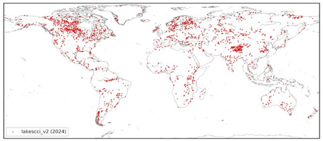
The lakes in the dataset were selected after an iterative process:
- The selection is first based on lake area, starting from the largest lakes and including additional lakes in descending size order.
- Several lakes were then added because there are substantial in situ reference records available, or because they had received priority in closely related activities under Copernicus.
- Some lakes were then excluded from the selection, due to having unsupported morphology, particularly with older sensors, resulting in a lack of valid observations.
Steps 1 and 3 were repeated until we arrived at the current selection.
The list those of lakes, including their location and thematic ECV data availability for version 2.1.0 can be downloaded in csv format (lakescci_v2.1_metadata) or shp format (lakescci_v2.1_shp).
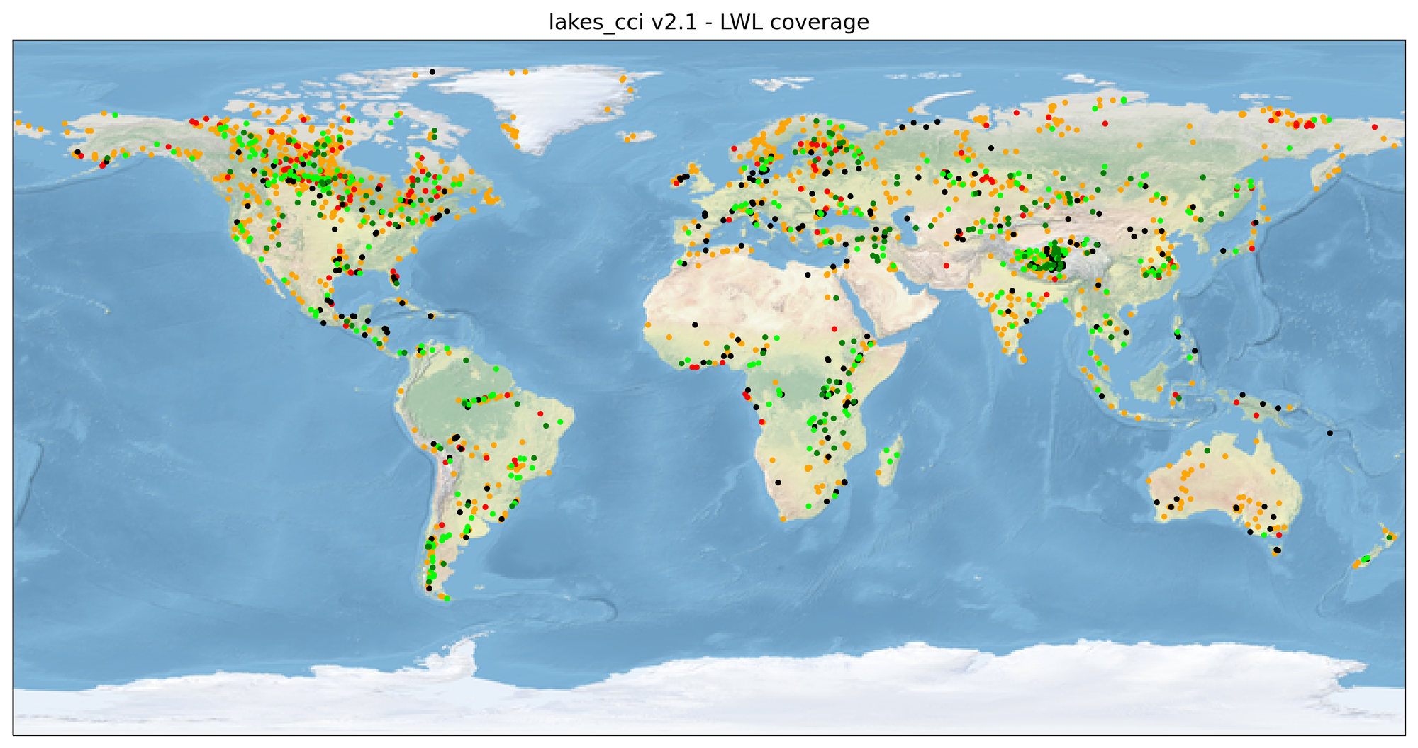
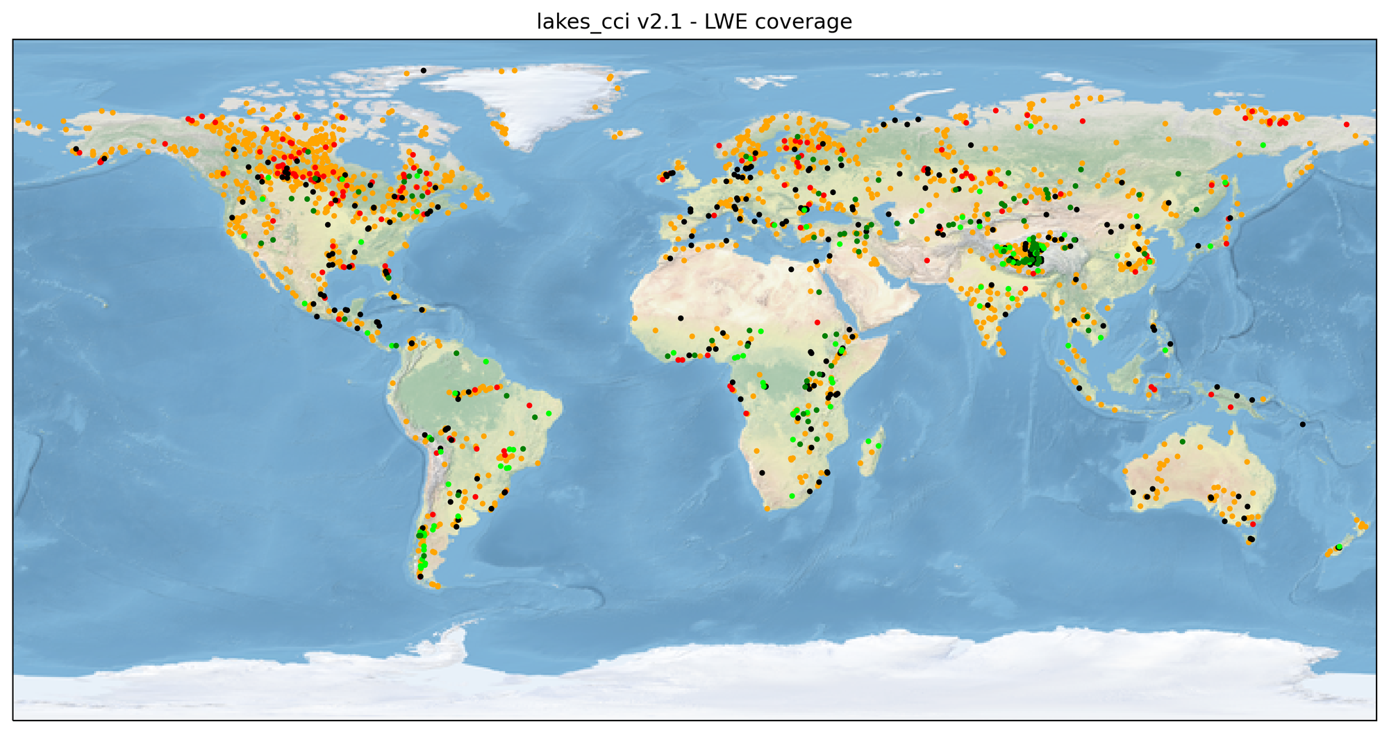
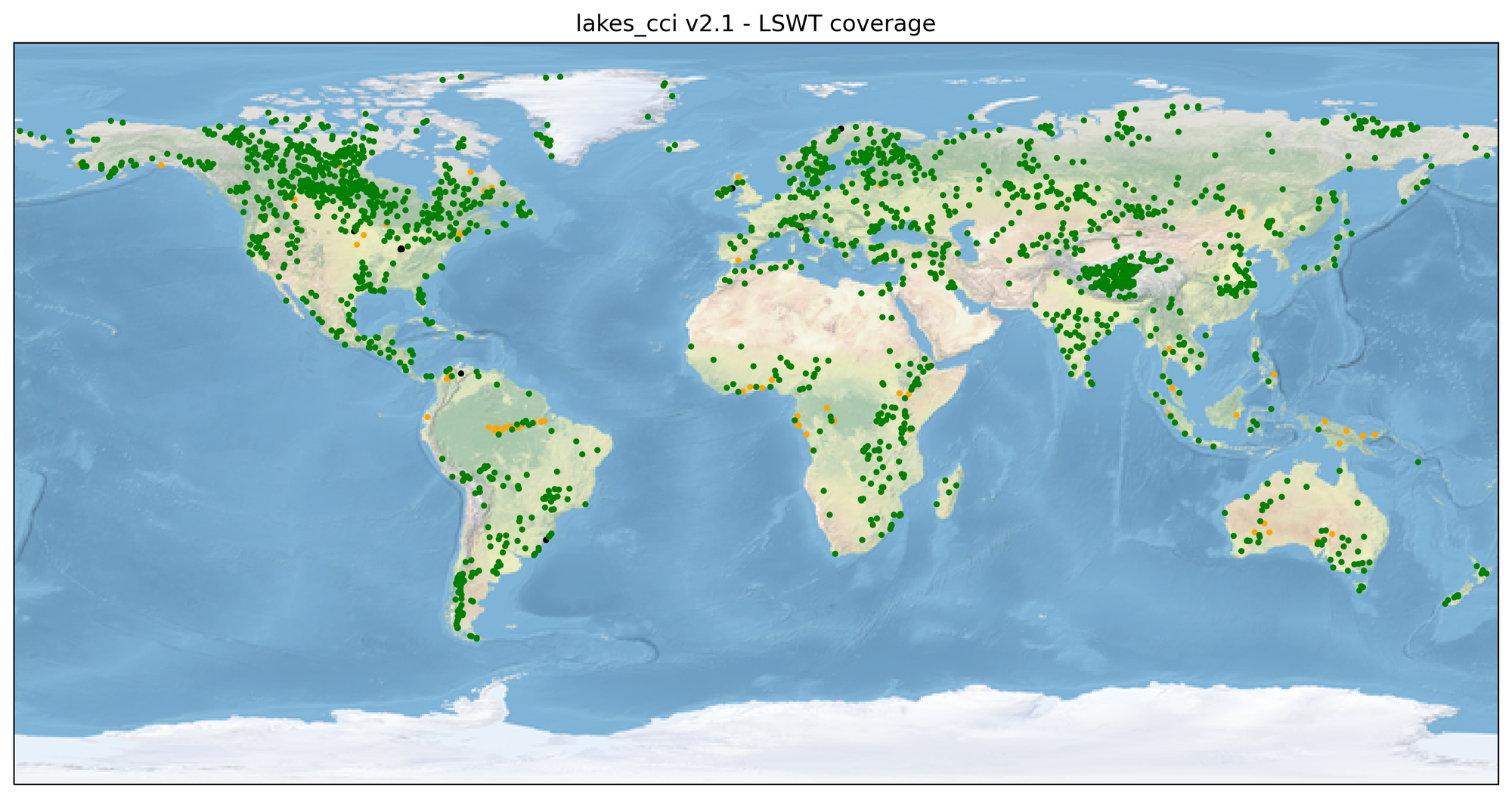
Data used for the generation of the lakes_cci products come from multiple instruments in different satellite missions. Therefore, the temporal resolution and spatial coverage are identical between the lake products. The figures below show the spatial coverage of Lake Water Level, Lake Water Extent and Lake Surface Water Temperature.
Specific observations:
The time interval of Lake Water Level and Lake Water Extent products is satellite dependent, ranging from daily for lakes observed by multiple missions/tracks to 27 days for lakes only observed by a single track of sentinel-3 instruments.
Lake Ice Cover data is available since 2001 for all lakes. However, only lakes that theoretically may form ice in winter are directly observed. A flag product is included to indicate which lakes have been inspected and which have been skipped.
Lake Water Leaving Reflectance data are available for all lakes since 2002. Among them, 48 lakes have complete datasets spanning from 2002 to 2022, while the remaining lakes have a gap in data between 2012 and 2016 due to a gap in usable satellite instruments.
Overall, data availability the can be classified into five categories, visualised per product in the maps below:
- Data available in at least 50% percent of datums in the most recent 16 years – dark green dots
- Data available in fewer than 50% of datums in the most recent 16 years – light green dots
- No observations from relevant satellite instruments – black dots
- No data due to low observation or product quality – red dots
- Lakes being considered for future data releases but not presently included – orange dots
The information on the data availability is included in the lakescci_v2.1_metadata file
Data Access
The official source for the latest version of the lakes_cci dataset (V2.1.0) is at the Centre for Environmental Data Analysis (CEDA): https://catalogue.ceda.ac.uk/uuid/7fc9df8070d34cacab8092e45ef276f1. CEDA offers multiple download mechanisms and ways to extract a set of variables, or data for a specific region.
The v2.1.0 data release combines Lake Water Level, Lake Water Extent, Lake Water-leaving Reflectance, Lake Surface Water Temperature and Lake Ice Cover.
A new variable, Lake Ice Thickness (LIT) is available for a single lake (Great Slave) in this version and is provided in a separate file.
Key improvements made to the ECV Products, compared with the previous dataset, include:
- Lake Water Level: Spatial coverage increased to 498 lakes as well as improved temporal coverage using data from past satellites. This represents approximately 50% of the number of lakes inspected for satellite observation of sufficient quality, to date (921 lakes investigated in total). A product quality variable has been added.
- Lake Water Extent: Spatial coverage increased to 207 lakes (from 84 in v2.0.2). The LWE data are directly linked with LWL observations, for lakes where a hypsometric relationship has been established. Thus, lakes where LWL are not available also do not have LWE estimates.
- Lake Water Leaving Reflectance: improved quality control in periods with ice cover, by clustering the observations of chlorophyll-a and turbidity in relation to LSWT climatology, masking outliers when low temperatures suggest (thin) ice cover is likely. In addition, spectral filters are used to determine the likelihood of adjacent land interfering with lake colour observations. A quality flag has been added describing several data quality risks. For 48 lakes, MODIS-Aqua have been processed to fill the observation gap between MERIS and OLCI instruments.
- Lakes Surface Water Temperature: reprocessed SLSTR-A and SLSTR-B. The reprocessing improved quality, reduced uncertainty and slightly increased the number of observations (in time and space) since all the SLSTR-A and SLSTR-B L1b files were NTC (Non-Time Critical) and therefore consolidated.
- Lake Ice Cover: increased temporal coverage for all lakes.
GitHub tools
To explore some of the ways in which you can extract data for a specific lake or region, we offer a series of python scripts and a jupyter notebook. These are intended to help new users familiarise themselves with data extraction for further analysis: project code repository.
Data Visualisation
WebGIS
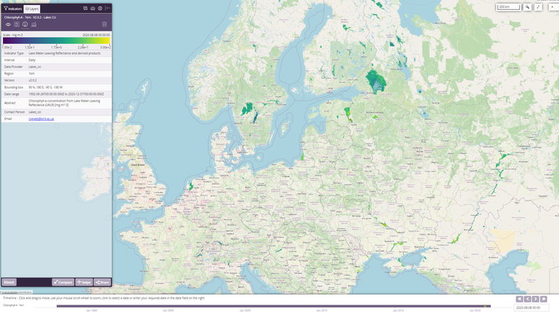
For interactive visualisation of the dataset you can use our WebGIS. The light-weight GIS provides visualisation of most variables (see figure below), and has functionality to extract small sections of the data for download or plotting (for larger requests, please use the CEDA tools). This is also a useful resource for training and education, e.g. by sharing links to your visualisation with others: https://lakescci.eofrom.space/
Climate Dashboard
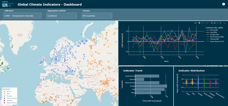
The Lakes_cci Global Climate Indicators Dashboard provides intuitive visualisation of change in lakes using a range of aggregation methods (e.g. per country, continent, by elevation, population pressure). Current indicators include the Lake Surface Water Temperature anomaly, lake heat wave occurrences and change in ice-covered area. The dashboard is hosted at https://lakescci.climate-indicators.brockmann-consult.de and will be extended with additional indicators and functionalities. Anyone interested in additional climate indicators is welcome to contact the developers at info@brockmann-consult.de
Multidecadal visualisations
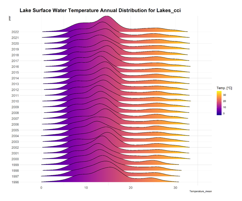
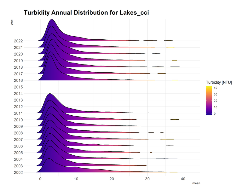
The figures below provide a birds-eye view of the latest dataset, showing the annual distribution of Essential Climate Variables across the full dataset.
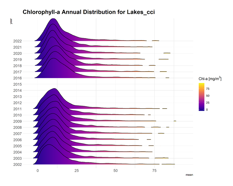
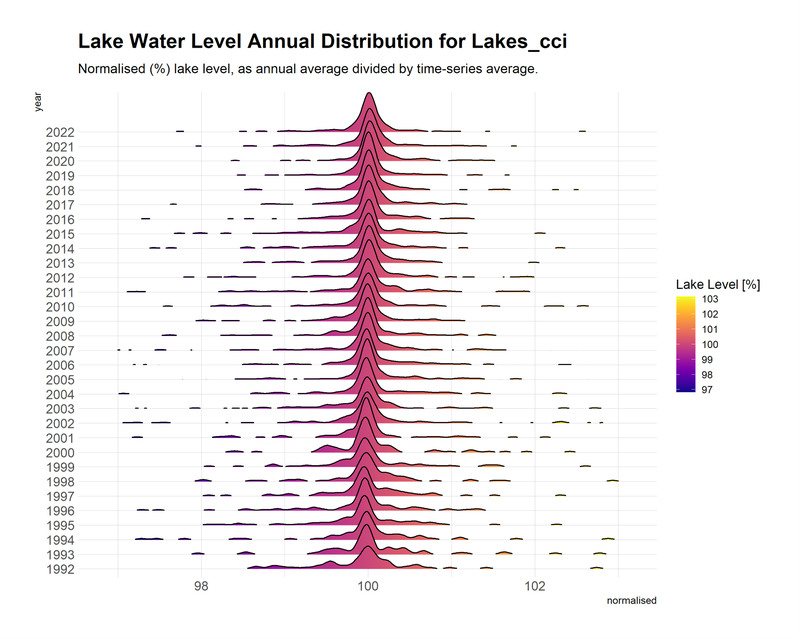
Please do not hesitate to get in touch for help with the data, or any other project information (lakes_cci@groupcls.com).
The following technical documentation describe the generation and validation of the Climate Research Data Package for the Lakes ECV: Phase 1 (CRDP V2.0) and Phase 2 (CRDP V2.1).
Additional documentation is available for specific thematic studies: Fire describing observability of wildfire impacts on lakes; Danube a case study on the climate data record for the Razelm-Sinoe lagoon; Ice Thickness detailing the intended technical approach to retrieve Lake Ice Thickness; Consistency detailing methods developed to determine inter-product consistency; Storage detailing methods developed to determine Lake Storage Change; CDOM detailing methods to determine the concentration of coloured dissolved matter.
The Lakes CCI ECV project phase 2 is carried out by a consortium of ten organisations from five ESA member states.
The consortium combines expertise in Earth Observation (EO), hydrology, limnology and climate change research communities.
- CLS, France (Lead)
- LEGOS, France
- University of Reading (UoR), UK
- National Research Council of Italy (CNR), Italy
- H2O Geomatics Inc (H2O Geo), Canada
- Brockman Consult GmbH (BC), Germany
- Plymouth Marine Laboratory (PML), United Kingdom
- Hygeos, France
- SERTIT, France
- University of Stirling, United Kingdom
Four additional project partners were involved during the first phase of the project:
- GeoEcoMar, Romania
- TRE-Altamira, Spain
- NORCE, Norway
- Eola, France
2025
A remote sensing approach for characterizing lake responses to heatwaves and monsoons: a case study from India. Rossana Caroni, Anna Joelle Greife, Mariano Bresciani, Claudia Giardino, Marina Amadori, Monica Pinardi. Journal of Water and Climate Change jwc2025097. https://doi.org/10.2166/wcc.2025.097. October 2025
A climatological baseline for understanding patterns of seasonal lake dynamics across sub-Sahelian Africa. Amadori, M., Greife, A.J., Carrea, L. et al. Commun Earth Environ 6, 681 (2025). https://doi.org/10.1038/s43247-025-02684-5
Factors influencing lake surface water temperature variability in West Greenland and the role of the ice sheet. Laura Carrea, Christopher J. Merchant, Richard I. Woolway, and Niall McCarroll. The Cryosphere, 19, 3139–3158, https://doi.org/10.5194/tc-19-3139-2025, 2025
A novel cyanobacteria occurrence index derived from optical water types in a tropical lake. Davide Lomeo, Stefan G.H. Simis, Xiaohan Liu, Nick Selmes, Mark A. Warren, Anne D. Jungblut, Emma J. Tebbs. ISPRS Journal of Photogrammetry and Remote Sensing, Volume 223, 2025, Pages 58-77, ISSN 0924-2716, https://doi.org/10.1016/j.isprsjprs.2025.03.006.
Examining global trends of satellite-derived water quality variables in shallow lakes. Rossana Caroni, Anna Joelle Greife, Mariano Bresciani, Claudia Giardino, Giulio Tellina, Laura Carrea, Xiaohan Liu, Stefan Simis, Clement Albergel, Monica Pinardi. Remote Sensing Applications: Society and Environment, 2025, 01565, ISSN 2352-9385, https://doi.org/10.1016/j.rsase.2025.101565.
2024
Improving the Estimation of Lake Ice Thickness with High-Resolution Radar Altimetry Data. Mangilli, A.; Duguay, C.R.; Murfitt, J.; Moreau, T.; Amraoui, S.; Mugunthan, J.S.; Thibaut, P.; Donlon, C. Remote Sens. 2024, 16, 2510. https://doi.org/10.3390/rs16142510
Lake surface water temperature [in State of the Climate Report] in Bulletins of the American Meteorological Society. Carrea, L., C.J. Merchant, R.I. Woolway et al (2024), 105 (8), S33-S35, https://doi.org/10.1175/BAMS-D-24-0116.1
Impacts of droughts and human activities on water quantity and quality: Remote sensing observations of Lake Qadisiyah, Iraq. Dalin Jiang, Ian Jones, Xiaohan Liu, Stefan G.H. Simis, Jean-François Cretaux, Clement Albergel, Andrew Tyler, Evangelos Spyrakos. International Journal of Applied Earth Observation and Geoinformation, Volume 132, 2024, 104021, ISSN 1569-8432. https://doi.org/10.1016/j.jag.2024.104021
Strengthening of the hydrological cycle in the Lake Chad Basin under current climate change. F. Sylvestre, A. Mahamat-Nour, T. Naradoum, M. Alcoba, L. Gal, A. Paris, J-F. Cretaux, B. Pham-Duc, M. Mahamat Ahmat, D. Gaya. Nat. Geosci. 17, 516–523 (2024). https://doi.org/10.1038/s41561-024-01446-w
Prospects of Using Satellite Data for Determining Water Levels in Large Lakes and Reservoirs: A Case Study for Russian Water Bodies. Vuglinskii, V.S., Cretaux, J.F., Izmailova, A.V. et al. Russ. Meteorol. Hydrol. 49, 1–8 (2024) https://doi.org/10.3103/S1068373924010011
Lake-TopoCat: A global lake drainage topology and catchment dataset. Sikder, M. S., Wang, J., Allen, G. H., Sheng, Y., Yamazaki, D., Song, C., Ding, M., Crétaux, J.-F., and Pavelsky, T. M., 2023. Earth System Science Data, 15, 3483-3511, https://doi.org/10.5194/essd-15-3483-2023
Slow response of surface water temperature to fast atmospheric variability reveals mixing heterogeneity in a deep lake. Amadori, M., Bresciani, M., Giardino, C. et al. Sci Rep 14, 8459 (2024). https://doi.org/10.1038/s41598-024-58547-0
Lake Water Temperature Modeling in an Era of Climate Change: Data Sources, Models, and Future Prospects. Piccolroaz, S., Zhu, S., Ladwig, R.,Carrea, L., Oliver, S., Piotrowski, A. P.,et al. (2024). Reviews of Geophysics,62, e2023RG000816. https://doi.org/10.1029/2023RG000816
Surface water temperature observations and ice phenology estimations for 1.4 million lakes globally. Maartje C. Korver, Bernhard Lehner, Jeffrey A. Cardille, Laura Carrea, Remote Sensing of Environment, Volume 308,2024,114164,ISSN 0034-4257, https://doi.org/10.1016/j.rse.2024.114164.
Challenges and prospects for modeling lake water temperature in a changing climate Piccolroaz, S., S. Zhu, R. Ladwig, L. Carrea, S. Oliver, A. P. Piotrowski, M. Ptak, R. Shinohara, M. Sojka, R. I. Woolway, and D. Z. Zhu (2024),, Eos, 105, https://doi.org/10.1029/2024EO245013. Published on 1st March
Quantifying decadal stability of lake reflectance and chlorophyll-a from medium-resolution ocean color sensors. Xiaohan Liu, Mark Warren, Nick Selmes, Stefan G.H. Simis. Remote Sensing of Environment, Volume 306, 2024, 114120, ISSN 0034-4257. https://doi.org/10.1016/j.rse.2024.114120.
Investigating the Impact of Wildfires on Lake Water Quality Using Earth Observation Satellites. Caroni, R.; Pinardi, M.; Free, G.; Stroppiana, D.; Parigi, L.; Tellina, G.; Bresciani, M.; Albergel, C.; Giardino, C. Appl. Sci. 2024, 14, 2626. https://doi.org/10.3390/app14062626
Detecting climate-related shifts in lakes: A review of the use of satellite Earth Observation. Calamita, E., Lever, J.J., Albergel, C., Woolway, R.I. and Odermatt, D. (2024) Limnol Oceanography, https://doi.org/10.1002/lno.12498
Lake Tanganyika basin water storage variations analysis over 2003-2021 for water balance monitoring and flood study. Gbetkom P., Cretaux J-F., Biancamaria S, Blazquez A, Gosset M, Paris A, Tchilibou M, Laetitia Gal L, Kitambo B, Jucá Oliveira R-A. 2024, Remote Sensing Applications: Society and Environment, 34, 101182, ISSN 2352-9385, https://doi.org/10.1016/j.rsase.2024.101182.
Lake Water Temperature Modeling in an Era of Climate Change: Data Sources, Models, and Future Prospects. S. Piccolroaz, S. Zhu, R. Ladwig, L. Carrea, S. Oliver, A. P. Piotrowski, M. Ptak, R. Shinohara, M. Sojka, R. I. Woolway, D. Z. Zhu. Reviews of Geophysics. https://doi.org/10.1029/2023RG000816
2023
Machine learning based classification of lake ice and open water from Sentinel-3 SAR altimetry waveforms. Jaya Sree Mugunthan, Claude R. Duguay, Elena Zakharova. Remote Sensing of Environment, Volume 299, 2023, 113891, ISSN 0034-4257, https://doi.org/10.1016/j.rse.2023.113891
Assessing the impact of wildfires on water quality using satellite remote sensing: the Lake Baikal case study. Pinardi M, Stroppiana D, Caroni R, Parigi L, Tellina G, Free G, Giardino C, Albergel C and Bresciani M (2023) Front. Remote Sens. 4:1107275. doi: 10.3389/frsen.2023.1107275
Satellites reveal widespread decline in global lake water storage. Fangfant Yao, Ben Livneh, Balaji Rajagopalan , Jida Wang, Jean-François Crétaux, Yoshihide Wada and Muriel Bergé-Nguyen. Science380,743-749(2023).DOI:10.1126/science.abo2812
Satellite-derived multivariate world-wide lake physical variable timeseries for climate studies. Laura Carrea, Jean-François Crétaux, Xiaohan Liu, Yuhao Wu, Beatriz Calmettes, Claude R. Duguay, Christopher J. Merchant, Nick Selmes, Stefan G. H. Simis, Mark Warren, Hervé Yesou, Dagmar Müller, Dalin Jiang, Owen Embury, Muriel Bergé-Nguyen & Clément Albergel . Sci Data 10, 30 (2023). https://doi.org/10.1038/s41597-022-01889-z
Lake Chad vegetation cover and surface water variations in response to rainfall fluctuations under recent climate conditions (2000−2020). Paul Gérard Gbetkom, Jean-François Crétaux, Michel Tchilibou, Alice Carret, Manon Delhoume, Muriel Bergé-Nguyen, Florence Sylvestre. Science of The Total Environment, 2023. https://doi.org/10.1016/j.scitotenv.2022.159302
A data-driven approach to flag land-affected signals in satellite derived water quality from small lakes. DalinJiang, JorritScholze, XiaohanLiu, Stefan G.H.Simis, KerstinStelzer, DagmarMüller, PeterHunter, AndrewTyler, EvangelosSpyrakos. International Journal of Applied Earth Observation and Geoinformation, Volume 117, 2023, 103188, ISSN 1569-8432, https://doi.org/10.1016/j.jag.2023.103188.
Comparison and correction of satellite measurements using in-situ observations of lake surface heights: A case study in lake Baikal. V.S. Vuglinsky, J-F Cretaux, A.V. Izmailova, S.I. Gusev, M. Berge-Nguyen, B. Calmettes. Advances in Space Research, Volume 71, Issue 10, 2023, Pages 4030-4044, ISSN 0273-1177, https://doi.org/10.1016/j.asr.2022.12.046.
Inland Surface Waters Quantity Monitored from Remote Sensing. Cretaux, JF., Calmant, S., Papa, F. et al. Surv Geophys 44, 1519–1552 (2023). https://doi.org/10.1007/s10712-023-09803-x
2022
A New Approach for the Estimation of Lake Ice Thickness From Conventional Radar Altimetry. A. Mangilli, P. Thibaut, C. R. Duguay and J. Murfitt. IEEE Transactions on Geoscience and Remote Sensing, vol. 60, pp. 1-15, 2022, Art no. 4305515, doi: 10.1109/TGRS.2022.3186253
Observing trends and extreme events impacts on lakes using ESA CCI Climate Research Data Package. Monica Pinardi, Mariano Bresciani, Giulio Tellina , Gary Free, Daniela Stroppiana, Claudia Giardino, Stefan Simis, Jean-Francois Crétaux, Chris Merchant, Herve Yesou, Claude Duguay, Clément Albergel, Alice Andral, Bruno Coulon. Poster. CMUG meeting 2022.
Consolidation of datasets of Essential Climate Variables: case of the Lake Water Extent exploiting HR Imagery and Altimetry times series withing the ESA CCI Lakes Framework. H. Yésout, J-F Cretaux, T. Ledauphin, R. Braun, A. Caretto, J. Maxant and A. Andral. Recent Advances in Quantitative Remote Sensing. Poster. 19-23 September 2022. Torrent (Valencia), Spain.
Water Resources in Africa under Global Change: Role of Earth Observation and Models for Monitoring Surface Waters. Papa F., Crétaux J-F., Grippa M., Robert E., Mark Trigg M., Tshimanga R., Kitambo B., Adrien A., Carr A., Fleischmann A., De Fleury M., Gbetkom P-G., Calmettes B., and Calmant S., 2022, , Survey In geophysics, https://doi.org/1009.1007/s10712-022-09700-9
Earlier ice loss accelerates lake warming in the Northern Hemisphere. Xinyu Li, Shushi Peng, Yi Xi, R. Iestyn Woolway & Gang Liu. Nat Commun 13, 5156 (2022).
Investigating lake chlorophyll-a responses to the 2019 European double heatwave using satellite remote sensing. Gary Free, Mariano Bresciani, Monica Pinardi, Stefan Simis, Xiaohan Liu, Clément Albergel, Claudia Giardino. Ecological Indicators, Volume 142, 2022, 109217, ISSN 1470-160X
Shorter blooms expected with longer warm periods under climate change: an example from a shallow mesoeutrophic Mediterranean lake. Gary Free . Mariano Bresciani. Monica Pinardi . Steef Peters . Marnix Laanen . Rosalba Padula . Alessandra Cingolani . Fedra Charavgis .Claudia Giardino. Hydrobiologia (Dordr., Online) ISSN: 1573-5117 Kluwer
2021
Giant ice rings in southern Baikal: multi-satellite data help to study ice cover dynamics and eddies under ice. Kouraev, A. V., Zakharova, E. A., Kostianoy, A. G., Shimaraev, M. N., Desinov, L. V., Petrov, E. A., Hall, N. M. J., Rémy, F., and Suknev, A. Y. The Cryosphere, 15, 4501–4516
Detecting climate driven changes in chlorophyll-a using high frequency monitoring: The impact of the 2019 european heatwave in three contrasting aquatic systems. Free, Gary; Bresciani, Mariano; Pinardi, Monica; Giardino, Claudia; Alikas, Krista; Kangro, Kersti; Rõõm, Eva Ingrid; Vaiciute, Diana; Bucas, Martynas; Ti?kus, Edvinas; Hommersom, Annelies; Laanen, Marnix; Peters, Steef. Sensors (Basel) ISSN: 1424-8220 Molecular Diversity Preservation International (MDPI)
Detecting Climate Driven Changes in Chlorophyll-a in Deep Subalpine Lakes Using Long Term Satellite Data. Gary Free, Mariano Bresciani , Monica Pinardi , Nicola Ghirardi , Giulia Luciani , Rossana Caroni and Claudia Giardino. Water (Basel) ISSN: 2073-4441 Molecular Diversity Preservation International
Assessment of machine learning classifiers for global ice cover mapping from MODIS TOA reflectance data. Wu, Y., C.R. Duguay and L. Xu, Remote Sensing of Environment.
River ice phenology and thickness from satellite altimetry. Potential for ice bridge road operation. Zakharova, E., S. Agafonova, C. Duguay C., N. Frolova, and A. Kouraev, E. et Al. The Cryosphere
Phenological shifts in lake stratification under climate change. R. Iestyn Woolway and al. Nature Communications.
2020
Consistency of Satellite Climate Data Records for Earth System Monitoring. Popp T, Hegglin MI, Hollmann R, Ardhuin F, Bartsch A, Bastos A, et al. BAMS
Climate velocity in inland standing waters. R. Iestyn Woolway and Stephen C. Maberly. Nature Climate Change
2019
Long-Term Water Surface Area Monitoring and Derived Water Level Using Synthetic Aperture Radar (SAR) at Altevatn, a Medium-Sized Arctic Lake. Vickers H., Malnes E. and Høgda K-A. Remote Sens. 2019, 11(23), 2780
Retrieval of Chlorophyll-a concentration and associated product uncertainty in optically diverse lakes and reservoirs. Xiaohan Liu, Christopher Steele, Stefan Simis, Mark Warren, Andrew Tyler, Evangelos Spyrakos, Nick Selmes, Peter Hunter. Remote Sensing of Environment
The following people can be contacted within the Lakes project.
Science Leaders:
- Jean François Crétaux – jean-francois.cretaux@legos.obs-mip.fr
- Stefan Simis – stsi@pml.ac.uk
Project Management:
- Project Manager – Philippe Mourot – pmourot@groupcls.com
- Project Officer – Beatriz Calmettes – bcalmettes@groupcls.com
Lake Water Level and Lake Water Extent:
- Jean François Crétaux – jean-francois.cretaux@cnes.fr
- Hervé Yésou – herve.yesou@unistra.fr
- Beatriz Calmettes – bcalmettes@groupcls.com
Lake Surface Water Temperature:
- Chris Merchant – c.j.merchant@reading.ac.uk
- Laura Carrea - l.carrea@reading.ac.uk
Lake Ice Cover and Lake Ice Thickness:
- Claude Duguay – claude.duguay@h2ogeomatics.com
- Justin Murfitt - justin.murfitt@h2ogeomatics.com
- Anna Mangilli - amangilli@groupcls.com
Lake Water Leaving Reflectance:
- Stefan Simis – stsi@pml.ac.uk
- Xiaohan Liu - liux@pml.ac.uk
Assessment of ECVs products:
- Claudia Giardino – giardino.c@irea.cnr.it
- Monica Pinardi - pinardi.m@irea.cnr.it
ESA Technical Officer:
- Clement Albergel – clement.albergel@esa.int
To run this example yourself, go to https://dashboard.climate.hub-otc.eox.at/. You can register for free.
Latest news & events

CCI colocation & CMUG integration meeting 2026
Annual gathering of the CCI community for ESA programme updates, scientific progress, and forward-looking discussions.
Learn more
World's lakes show severe climate fingerprint as the global water crisis deepens
European satellite data reveal how space-based monitoring supports critical water resource assessments
Learn more
Satellites reveal hidden climate vulnerabilities of sub-Sahelian lakes
Study sets baseline for climate-related research on 137 freshwater ecosystems
Learn more
Working for ESA: procurement and proposal submission process
An Introduction to ESA Star - ESA's System for Tendering and Registration
Learn more
ESA at COP29
ESA is participating in COP29 to highlighting satellites' role in tackling climate change
Learn more
Land Surface Temperature 2024 User Workshop Save the date: 5th and 6th December 2024
Call for abstracts and registration
Learn more
Disproportionate Impact of Atmospheric Heat on Lake Temperatures: new study
Study makes use of ESA lake satellite-based climate data record
Learn more
Call for abstracts: The 7th LAKES Workshop on Parametrization of Lakes in Numerical Weather Prediction and Climate Modelling
Call for abstracts
Learn more
Call for new projects: Additional Essential Climate Variables
New R&D procurement as part of ESA's CLIMATE-SPACE programme
Learn more
Lake expert wins the 2024 Earth Observation Excellence Award
Winner, Iestyn Woolway, spent his ESA Research Fellowship with the ESA Climate Office in Oxfordshire, UK
Learn more
Open Competitive Tender for CLIMATE-SPACE Knowledge Exchange
ESA Tender Action Number: 1-12141. ESA Activity Number: 1000039650.
Learn more


